Crooksville, Ohio
| Crooksville, Ohio | |
|---|---|
| Village | |
|
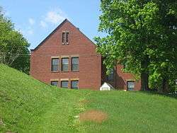
Crooksville's historic West School | |
| Nickname(s): "The Clay City of Perry County", "Potteryland USA" | |
 Location of Crooksville, Ohio | |
 Location of Crooksville in Perry County | |
| Coordinates: 39°46′9″N 82°5′41″W / 39.76917°N 82.09472°WCoordinates: 39°46′9″N 82°5′41″W / 39.76917°N 82.09472°W | |
| Country | United States |
| State | Ohio |
| County | Perry |
| Area[1] | |
| • Total | 1.64 sq mi (4.25 km2) |
| • Land | 1.62 sq mi (4.20 km2) |
| • Water | 0.02 sq mi (0.05 km2) |
| Elevation[2] | 784 ft (239 m) |
| Population (2010)[3] | |
| • Total | 2,534 |
| • Estimate (2012[4]) | 2,518 |
| • Density | 1,564.2/sq mi (603.9/km2) |
| Time zone | Eastern (EST) (UTC-5) |
| • Summer (DST) | EDT (UTC-4) |
| ZIP code | 43731 |
| Area code(s) | 740 |
| FIPS code | 39-19456[5] |
| GNIS feature ID | 1056852[2] |
Crooksville is a village in Perry County, Ohio, United States, along Moxahala Creek. The population was 2,534 at the 2010 census. It is the home of Hull pottery, one of the best known Ohio potteries.
Geography
Crooksville is located at 39°46′9″N 82°5′41″W / 39.76917°N 82.09472°W (39.769070, -82.094733).[6]
According to the United States Census Bureau, the village has a total area of 1.64 square miles (4.25 km2), of which 1.62 square miles (4.20 km2) is land and 0.02 square miles (0.05 km2) is water.[1]
History
Crooksville was founded around 1874.[7]
Demographics
| Historical population | |||
|---|---|---|---|
| Census | Pop. | %± | |
| 1900 | 835 | — | |
| 1910 | 3,028 | 262.6% | |
| 1920 | 3,311 | 9.3% | |
| 1930 | 3,251 | −1.8% | |
| 1940 | 2,890 | −11.1% | |
| 1950 | 2,960 | 2.4% | |
| 1960 | 2,958 | −0.1% | |
| 1970 | 2,828 | −4.4% | |
| 1980 | 2,766 | −2.2% | |
| 1990 | 2,601 | −6.0% | |
| 2000 | 2,483 | −4.5% | |
| 2010 | 2,534 | 2.1% | |
| Est. 2015 | 2,498 | [8] | −1.4% |
2010 census
As of the census[3] of 2010, there were 2,534 people, 977 households, and 651 families residing in the village. The population density was 1,564.2 inhabitants per square mile (603.9/km2). There were 1,094 housing units at an average density of 675.3 per square mile (260.7/km2). The racial makeup of the village was 98.5% White, 0.1% African American, 0.1% Native American, 0.1% Asian, 0.2% from other races, and 0.9% from two or more races. Hispanic or Latino of any race were 0.7% of the population.
There were 977 households of which 38.7% had children under the age of 18 living with them, 45.3% were married couples living together, 15.6% had a female householder with no husband present, 5.7% had a male householder with no wife present, and 33.4% were non-families. 27.8% of all households were made up of individuals and 12.1% had someone living alone who was 65 years of age or older. The average household size was 2.59 and the average family size was 3.15.
The median age in the village was 34.4 years. 29.7% of residents were under the age of 18; 8.4% were between the ages of 18 and 24; 26.1% were from 25 to 44; 22.8% were from 45 to 64; and 12.8% were 65 years of age or older. The gender makeup of the village was 48.1% male and 51.9% female.
2000 census
As of the census[5] of 2000, there were 2,483 people, 968 households, and 664 families residing in the village. The population density was 1,627.6 people per square mile (626.6/km²). There were 1,068 housing units at an average density of 700.1 per square mile (269.5/km²). The racial makeup of the village was 98.47% White, 0.24% African American, 0.20% Native American, 0.04% Asian, and 1.05% from two or more races. Hispanic or Latino of any race were 0.40% of the population.
There were 968 households out of which 35.8% had children under the age of 18 living with them, 51.4% were married couples living together, 12.4% had a female householder with no husband present, and 31.4% were non-families. 27.2% of all households were made up of individuals and 15.9% had someone living alone who was 65 years of age or older. The average household size was 2.57 and the average family size was 3.07.
In the village the population was spread out with 28.5% under the age of 18, 9.2% from 18 to 24, 29.2% from 25 to 44, 19.2% from 45 to 64, and 13.9% who were 65 years of age or older. The median age was 33 years. For every 100 females there were 89.1 males. For every 100 females age 18 and over, there were 84.1 males.
The median income for a household in the village was $26,838, and the median income for a family was $34,615. Males had a median income of $27,115 versus $20,179 for females. The per capita income for the village was $14,995. About 9.4% of families and 13.6% of the population were below the poverty line, including 18.4% of those under age 18 and 10.4% of those age 65 or over.
Arts and culture
In mid-July, Crooksville, along with its neighboring village of Roseville, annually hosts the Crooksville-Roseville Pottery festival, which emphasizes various aspects of pottery creation, design, collection, etc. This festival draws pottery connoisseurs from all over the country.
References
- 1 2 "US Gazetteer files 2010". United States Census Bureau. Archived from the original on January 24, 2012. Retrieved 2013-01-06.
- 1 2 "US Board on Geographic Names". United States Geological Survey. 2007-10-25. Retrieved 2008-01-31.
- 1 2 "American FactFinder". United States Census Bureau. Retrieved 2013-01-06.
- ↑ "Population Estimates". United States Census Bureau. Archived from the original on June 17, 2013. Retrieved 2013-06-17.
- 1 2 "American FactFinder". United States Census Bureau. Archived from the original on September 11, 2013. Retrieved 2008-01-31.
- ↑ "US Gazetteer files: 2010, 2000, and 1990". United States Census Bureau. 2011-02-12. Retrieved 2011-04-23.
- ↑ Colborn, Ephraim S. (1883). History of Fairfield and Perry Counties, Ohio. Brookhaven Press. p. 194.
- ↑ "Annual Estimates of the Resident Population for Incorporated Places: April 1, 2010 to July 1, 2015". Retrieved July 2, 2016.
- ↑ "Census of Population and Housing". Census.gov. Archived from the original on May 11, 2015. Retrieved June 4, 2015.
External links
Municipalities and communities of Perry County, Ohio, United States | ||
|---|---|---|
| Villages |  | |
| Townships | ||
| CDP | ||
| Unincorporated communities | ||
| Ghost towns | ||
| Footnotes | ‡This populated place also has portions in an adjacent county or counties | |