Cove Creek Township, Washington County, Arkansas
| Township of Cove Creek | |
|---|---|
| Township | |
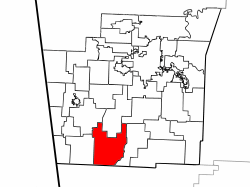 Location of Cove Creek Township in Washington County | |
 Location of Washington County in Arkansas | |
| Coordinates: 35°49′00″N 94°18′00″W / 35.81667°N 94.30000°WCoordinates: 35°49′00″N 94°18′00″W / 35.81667°N 94.30000°W | |
| Country |
|
| State |
|
| County | Washington |
| Established | 1842[1] |
| Area | |
| • Total | 45.9 sq mi (119 km2) |
| • Land | 45.9 sq mi (119 km2) |
| • Water | 0.0 sq mi (0 km2) 0% |
| Elevation | 1,781 ft (543 m) |
| Population (2000)[2] | |
| • Total | 683 |
| • Density | 15/sq mi (6/km2) |
| Time zone | CST (UTC-6) |
| • Summer (DST) | CDT (UTC-5) |
| Area code(s) | 479 |
| GNIS feature ID | 69783 |
| U.S. Geological Survey Geographic Names Information System: Cove Creek Township, Washington County, Arkansas | |
Township of Cove Creek is one of thirty-seven townships in Washington County, Arkansas, USA.[2] As of the 2000 census, its total population was 683. Part of Devil's Den State Park is located in Cove Creek Township.
Geography
According to the United States Census Bureau, Cove Creek Township covers an area of 45.9 square miles (119 km2); all land.[2] Cove Creek Township was created in 1842 from parts of Mountain Township. It gave part to Lee's Creek Township in 1880.[1]
Cities, towns, villages
Cemeteries
The township contains Dunkard, Liberty, Morrow, and Scott Cemeteries.
Major routes
References
- United States Census Bureau 2008 TIGER/Line Shapefiles
- United States Board on Geographic Names (GNIS)
- United States National Atlas
External links
 |
Cane Hill Township | Valley Township | West Fork Township | |
| Boston Township | |
Lee's Creek Township | ||
| ||||
| | ||||
| Barker Township, Crawford County | Cove City Township, Crawford County | Upper Township, Crawford County |
This article is issued from Wikipedia - version of the 9/13/2016. The text is available under the Creative Commons Attribution/Share Alike but additional terms may apply for the media files.