Oldham Clegg Street railway station
| Oldham Clegg Street | |
|---|---|
| Location | |
| Place | Oldham |
| Area | Oldham |
| Coordinates | 53°32′16″N 2°06′41″W / 53.53771°N 2.11131°WCoordinates: 53°32′16″N 2°06′41″W / 53.53771°N 2.11131°W |
| Grid reference | SD928046 |
| Operations | |
| Original company | Oldham, Ashton and Guide Bridge Railway |
| Pre-grouping | OAGB |
| Post-grouping | OAGB |
| History | |
| 26 August 1861 | Opened |
| 4 May 1959 | Closed |
| Disused railway stations in the United Kingdom | |
|
Closed railway stations in Britain A B C D–F G H–J K–L M–O P–R S T–V W–Z | |
|
| |
Oldham Clegg Street railway station was one of five stations that served the town of Oldham in northwest England.
History
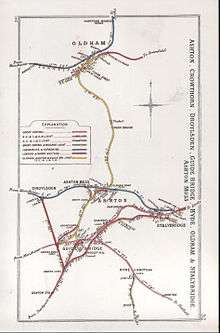
A 1912 Railway Clearing House map of railways in the vicinity of Oldham Clegg Street
The station was the northernmost passenger station on the Oldham, Ashton and Guide Bridge Railway;[1][2] it opened on 26 August 1861.[3] To the south of the station was a tunnel, known as Oldham Tunnel; it was 59 yards (54 m) in length.[4]
The station was reconstructed in the late 1890s, the works being finished in 1900.[4] The station closed on 4 May 1959.[3]
Routes
| Oldham Lines | ||||||||||||||||||||||||||||||||||||||||||||||||||||||||||||||||||||||||||||||||||||||||||||||||||||||||||||||||||||||||||||||||||||||||||||||||||||||||||||||||||||||||||||||||||||||||||||||||||||||||||||||||||||
|---|---|---|---|---|---|---|---|---|---|---|---|---|---|---|---|---|---|---|---|---|---|---|---|---|---|---|---|---|---|---|---|---|---|---|---|---|---|---|---|---|---|---|---|---|---|---|---|---|---|---|---|---|---|---|---|---|---|---|---|---|---|---|---|---|---|---|---|---|---|---|---|---|---|---|---|---|---|---|---|---|---|---|---|---|---|---|---|---|---|---|---|---|---|---|---|---|---|---|---|---|---|---|---|---|---|---|---|---|---|---|---|---|---|---|---|---|---|---|---|---|---|---|---|---|---|---|---|---|---|---|---|---|---|---|---|---|---|---|---|---|---|---|---|---|---|---|---|---|---|---|---|---|---|---|---|---|---|---|---|---|---|---|---|---|---|---|---|---|---|---|---|---|---|---|---|---|---|---|---|---|---|---|---|---|---|---|---|---|---|---|---|---|---|---|---|---|---|---|---|---|---|---|---|---|---|---|---|---|---|---|---|---|
Legend | ||||||||||||||||||||||||||||||||||||||||||||||||||||||||||||||||||||||||||||||||||||||||||||||||||||||||||||||||||||||||||||||||||||||||||||||||||||||||||||||||||||||||||||||||||||||||||||||||||||||||||||||||||||
| ||||||||||||||||||||||||||||||||||||||||||||||||||||||||||||||||||||||||||||||||||||||||||||||||||||||||||||||||||||||||||||||||||||||||||||||||||||||||||||||||||||||||||||||||||||||||||||||||||||||||||||||||||||
| Preceding station | Disused railways | Following station | ||
|---|---|---|---|---|
| Park Bridge Line and station closed |
Lancashire and Yorkshire Railway London and North Western Railway Great Central Railway Oldham, Ashton and Guide Bridge Railway |
Oldham Mumps Line closed, station open | ||
| Oldham Glodwick Road Line and station closed | ||||
Notes
References
- Bairstow, Martin. The Manchester and Leeds Railway.
- Butt, R.V.J. (1995). The Directory of Railway Stations. Yeovil: Patrick Stephens Ltd. ISBN 1-85260-508-1. R508.
- British Railways Pre-Grouping Atlas and Gazetteer (Map) (5th ed.). 1" = 8 miles. Cartography by W. Philip Conolly. Ian Allan. 1976. ISBN 0-7110-0320-3.
- Dow, George (1959). Great Central, Volume One: The Progenitors, 1813-1863. Shepperton: Ian Allan. ISBN 0-7110-1468-X.
- Dow, George (1962). Great Central, Volume Two: Dominion of Watkin, 1864-1899. Shepperton: Ian Allan. ISBN 0-7110-1469-8.
- Hooper, John. An Illustrated History of Oldham's Railways. ISBN 1-871608-19-8.
- Wells, Jeffrey. The Oldham Loop. ISBN 1-870119-76-2.
This article is issued from Wikipedia - version of the 12/2/2016. The text is available under the Creative Commons Attribution/Share Alike but additional terms may apply for the media files.