Partington railway station
| Partington | |
|---|---|
| Location | |
| Place | Partington |
| Area | Trafford |
| Grid reference | SJ724917 |
| Operations | |
| Original company | Cheshire Lines Committee |
| Pre-grouping | Cheshire Lines Committee |
| Post-grouping | Cheshire Lines Committee |
| Platforms | 2 |
| History | |
| May 1874 | Station opened |
| 29 May 1893 | Station resited |
| 30 November 1964 | Station closed |
| Disused railway stations in the United Kingdom | |
|
Closed railway stations in Britain A B C D–F G H–J K–L M–O P–R S T–V W–Z | |
|
| |
Partington railway station was situated on the Cheshire Lines Committee route between Warrington and Stockport.[1] It served the locality between 1874 and 1964.
History
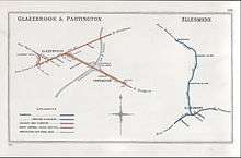
The line between Skelton West Junction and Cressington Junction was opened for goods traffic on 1 March 1873, with passenger trains beginning on 1 August 1873.[2] The first station named Partington was opened on that line in May 1874.[3]
The construction of the Manchester Ship Canal, which was to cross the line between Partington and Cadishead, meant that the railway had to be raised by 43 feet (13 m) in order to give a 75-foot (23 m) clearance for shipping. A new line, parallel to the old but slightly to the south-west, was built on embankments formed using the soil excavated from the new canal; it included the new Cadishead Viaduct. The new line was brought into use for goods traffic on 27 February 1893; a new Partington station was built on that line, and passenger traffic was transferred from the old line to the new on 29 May 1893, in plenty of time for the opening of the Ship Canal on 1 January 1894.[3][4] The new station was 191 miles 23 chains (307.8 km) from London St Pancras, and 26 miles 36 chains (42.6 km) from Liverpool Central.[5]
The second station was closed on 30 November 1964.[3]
Routes
| Preceding station | Disused railways | Following station | ||
|---|---|---|---|---|
| Cadishead Line and station closed |
Cheshire Lines Committee Glazebrook East Junction to Skelton Junction Line |
West Timperley Line and station closed | ||
Notes
References
- Butt, R. V. J. (1995). The Directory of Railway Stations. Yeovil: Patrick Stephens Ltd. ISBN 1-85260-508-1. R508.
- Conolly, W. Philip (January 1976). British Railways Pre-Grouping Atlas and Gazetteer (5th ed.). Shepperton: Ian Allan. ISBN 0-7110-0320-3. EX/0176.
- Dow, George (1962). Great Central, Volume Two: Dominion of Watkin, 1864–1899. Shepperton: Ian Allan. ISBN 0-7110-1469-8.
- Midland Railway System Maps (The Distance Diagrams) Volume 2 Leeds to Leicester and branches; Derby to Manchester and branches; Cheshire Lines (Map) (1909–1923 ed.). Peter Kay. 1998. ISBN 1-899890-17-3.
External links
Coordinates: 53°25′18″N 2°25′03″W / 53.4218°N 2.4175°W