Manchester Oldham Road railway station
| Manchester Oldham Road | |
|---|---|
| Location | |
| Place | Manchester |
| Area | City of Manchester |
| Grid reference | SJ847989 |
| Operations | |
| Original company | Manchester and Leeds Railway |
| History | |
| 3 July 1839 | Station opened |
| 1 January 1844 | Closed to passengers |
| 7 October 1968 | Closed to freight |
| Disused railway stations in the United Kingdom | |
|
Closed railway stations in Britain A B C D–F G H–J K–L M–O P–R S T–V W–Z | |
|
| |
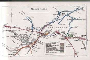
Manchester Oldham Road was a railway station built on the Manchester and Leeds Railway (M&LR) in Miles Platting, Greater Manchester.[1] Built in 1839 and opened on 3 July, it was the Manchester terminus for the railway.
History
The station was built in 1839 on the north side of Oldham Road,[2] and the east side of Lees Street.[3] The line reached the station by a viaduct, 30 feet above the surrounding streets. A 'flight of spacious stairs' was used by passengers to reach the 'very commodious' station building.[4] M&LR passenger trains from and to Yorkshire served the station from its opening on 3 July.[5]
In 1839, both the M&LR and the Liverpool and Manchester Railway realised that their respective stations were too far from the city centre. Despite the conflicting aspirations of the two companies, negotiations between the two resulted in agreement to build a new station at the central location of Hunt's Bank, with the M&LR to have control.[6] The M&LRs extension of the line to the newly completed Manchester Victoria at Hunts Bank opened on 1 January 1844 and the original M&LR station closed for passenger use on the same date.[5] An Act of Parliament, receiving royal assent had been obtained on 1 July 1839, enabling construction of this extension.[7]
Once the M&LRs new extension had been opened, Oldham Road station was converted from passenger use to the receipt, unloading, storing and despatch of goods. From 1844, goods trains operated along what was now a short branch line (72-chains in length) from Oldham Road Junction near Miles Platting station. Waggons of 8 metric tons (7.9 long tons) or more were raised and lowered from the goods yard at street level below by a double hoist.[8] The business offices (including the Superintendent's office) of the railway remained at the station.[9]
The goods depot continued to grow in size throughout the nineteenth century under the ownership of the Lancashire and Yorkshire Railway and was completely rebuilt in 1916.[10] In its final form it had a number of 'sheds', which were called the Fruit Shed, Provision Shed, Delivery Shed, Fish Shed, Cloth Shed, Grain Shed, Potato Shed and the Shipping Shed, indicating the diversity of traffic handled there.[10] British Railways London Midland Region continued to handle sundries traffic at Oldham Road for some years after the nationalisation of 1948.[11]
Current status
The area is very different from what it once was. The station and line no longer exist, although part of the viaduct which led to it is still visible from the railway line from Victoria to Miles Platting and from the eastern end of New Allen Street. Most of the old station and sidings have since been replaced by a large Royal Mail sorting depot.[12]
References
- ↑ Love 1839, p. 234.
- ↑ Parkinson-Bailey 2000, p. 53.
- ↑ Not to be confused with Lees Street in Openshaw - Lees Street in Miles Platting no longer exists
- ↑ Holt 1978, p. 109
- 1 2 Butt 1995, p. 154
- ↑ Ferneyhough 1980, pp. 103–104
- ↑ Whishaw 1842, p. 314.
- ↑ The line at this point was a considerable height above the street below
- ↑ N/A 1844, p. 304.
- 1 2 Hall 1995, p. 58
- ↑ Hall, p. 129
- ↑ http://www.ordnancesurvey.co.uk/oswebsite/
Bibliography
- Butt, R.V.J. (1995), The Directory of Railway Stations, Patrick Stephens, ISBN 1-85260-508-1
- Ferneyhough, Frank (1980), Liverpool & Manchester Railway, Book Club Associates
- Hall, Stanley (1995), Rail Centres: Manchester, Ian Allan Ltd, ISBN 0-7110-2356-5
- Holt, Geoffrey O. (1978), A Regional History of the Railways of Great Britain - Volume 10 - The North West, David & Charles, ISBN 0-7153-7521-0
- N/A (1844), The Law Times, Oxford University: Office of The Law times
- Parkinson-Bailey, John (2000), Manchester: An Architectural History, Manchester University Press, ISBN 0-7190-5606-3
- Whishaw, Francis (1842), The Railways of Great Britain and Ireland Practically Described and Illustrated, John Wheale
| Preceding station | Disused railways | Following station | ||
|---|---|---|---|---|
| Terminus | M&LR | Middleton Junction | ||
| Manchester Lines | |||||||||||||||||||||||||||||||||||||||||||||||||||||||||||||||||||||||||||||||||||||||||||||||||||||||||||||||||||||||||||||||||||||||||||||||||||||||||||||||||||||||||||||||||||||||||||||||||||||||||||||||||||||||||||||||||||||||||||||||||||||||||||||||||||||||||||||||||||||||||||||||||||||||||||||||||||||||||||||||||||||||||||||||||||||||||||||||||||||||||||||||||||||||||||||||||||||||||||||||||||||||||||||
|---|---|---|---|---|---|---|---|---|---|---|---|---|---|---|---|---|---|---|---|---|---|---|---|---|---|---|---|---|---|---|---|---|---|---|---|---|---|---|---|---|---|---|---|---|---|---|---|---|---|---|---|---|---|---|---|---|---|---|---|---|---|---|---|---|---|---|---|---|---|---|---|---|---|---|---|---|---|---|---|---|---|---|---|---|---|---|---|---|---|---|---|---|---|---|---|---|---|---|---|---|---|---|---|---|---|---|---|---|---|---|---|---|---|---|---|---|---|---|---|---|---|---|---|---|---|---|---|---|---|---|---|---|---|---|---|---|---|---|---|---|---|---|---|---|---|---|---|---|---|---|---|---|---|---|---|---|---|---|---|---|---|---|---|---|---|---|---|---|---|---|---|---|---|---|---|---|---|---|---|---|---|---|---|---|---|---|---|---|---|---|---|---|---|---|---|---|---|---|---|---|---|---|---|---|---|---|---|---|---|---|---|---|---|---|---|---|---|---|---|---|---|---|---|---|---|---|---|---|---|---|---|---|---|---|---|---|---|---|---|---|---|---|---|---|---|---|---|---|---|---|---|---|---|---|---|---|---|---|---|---|---|---|---|---|---|---|---|---|---|---|---|---|---|---|---|---|---|---|---|---|---|---|---|---|---|---|---|---|---|---|---|---|---|---|---|---|---|---|---|---|---|---|---|---|---|---|---|---|---|---|---|---|---|---|---|---|---|---|---|---|---|---|---|---|---|---|---|---|---|---|---|---|---|---|---|---|---|---|---|---|---|---|---|---|---|---|---|---|---|---|---|---|---|---|---|---|---|---|---|---|---|---|---|---|---|---|---|---|---|---|---|---|---|---|---|---|---|---|---|---|---|---|---|---|---|---|---|---|---|---|---|---|---|---|---|---|---|---|---|---|---|---|---|---|---|---|---|---|---|---|---|---|---|
Legend | |||||||||||||||||||||||||||||||||||||||||||||||||||||||||||||||||||||||||||||||||||||||||||||||||||||||||||||||||||||||||||||||||||||||||||||||||||||||||||||||||||||||||||||||||||||||||||||||||||||||||||||||||||||||||||||||||||||||||||||||||||||||||||||||||||||||||||||||||||||||||||||||||||||||||||||||||||||||||||||||||||||||||||||||||||||||||||||||||||||||||||||||||||||||||||||||||||||||||||||||||||||||||||||
| |||||||||||||||||||||||||||||||||||||||||||||||||||||||||||||||||||||||||||||||||||||||||||||||||||||||||||||||||||||||||||||||||||||||||||||||||||||||||||||||||||||||||||||||||||||||||||||||||||||||||||||||||||||||||||||||||||||||||||||||||||||||||||||||||||||||||||||||||||||||||||||||||||||||||||||||||||||||||||||||||||||||||||||||||||||||||||||||||||||||||||||||||||||||||||||||||||||||||||||||||||||||||||||
Coordinates: 53°29′14″N 2°13′44″W / 53.487216°N 2.228851°W