Brierley Hill railway station
| Brierley Hill | |
|---|---|
|
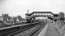
The station in 1962 | |
| Location | |
| Place | Dudley |
| Area | West Midlands |
| Operations | |
| Original company | Oxford, Worcester and Wolverhampton Railway |
| Post-grouping | Great Western Railway |
| Platforms | 2 |
| History | |
| 1858 | Station opens |
| 30 July 1962 | Station closes [1] |
| Disused railway stations in the United Kingdom | |
|
Closed railway stations in Britain A B C D–F G H–J K–L M–O P–R S T–V W–Z | |
|
| |
Brierley Hill railway station was a station on the Oxford-Worcester-Wolverhampton Line.
History
It was opened in 1858. British Rail closed the station pre-Beeching in 1962. Two railways/routes served the station - originally the Oxford, Worcester and Wolverhampton Railway and the South Staffordshire Railway, which later became the Great Western Railway and London, Midland and Scottish Railway (through amalgamation of the London and North Western Railway) respectively.
Today's usage
The station's pedestrian entrance from Station Road is still in existence, though it has long been blocked off by a fence.
Today, Goods trains still use the track where the station once stood, on their way to the nearby Round Oak Steel Terminal.
Re-opening
In January 2012, plans were announced to run a passenger service between Stourbridge Junction and Brierley Hill, with stations being re-opened along the route, including Brierley Hill. The service would be operated by railcars built by Parry People Movers, who built the Class139 units which run the Stourbridge Town service. Another plan is for the entire line to re-open the South Staffs Line with passenger and freight trains between Stourbridge and Walsall.[2] In late 2015 plans emerged to re-open the Dudley Port railway station to Stourbridge line as the fact of trams serving on the same line as freight trains became extremely unlikely.
References
| Midland Metro Line Two Proposed Merry Hill Extension | ||||||||||||||||||||||||||||||||||||||||||||||||||||||||||||||||||||||||||||||||||||||||||||||||||||||||||||||||||||||||||
|---|---|---|---|---|---|---|---|---|---|---|---|---|---|---|---|---|---|---|---|---|---|---|---|---|---|---|---|---|---|---|---|---|---|---|---|---|---|---|---|---|---|---|---|---|---|---|---|---|---|---|---|---|---|---|---|---|---|---|---|---|---|---|---|---|---|---|---|---|---|---|---|---|---|---|---|---|---|---|---|---|---|---|---|---|---|---|---|---|---|---|---|---|---|---|---|---|---|---|---|---|---|---|---|---|---|---|---|---|---|---|---|---|---|---|---|---|---|---|---|---|---|---|
Legend | ||||||||||||||||||||||||||||||||||||||||||||||||||||||||||||||||||||||||||||||||||||||||||||||||||||||||||||||||||||||||||
| ||||||||||||||||||||||||||||||||||||||||||||||||||||||||||||||||||||||||||||||||||||||||||||||||||||||||||||||||||||||||||
- ↑ Butt, R.V.J., (1995) The Directory of Railway Stations, Yeovil: Patrick Stephens
- ↑ http://www.stourbridgenews.co.uk/news/8927004.Stourbridge_to_Walsall_train_tram_plan_is_on_the_right_lines/
External links
Further reading
- Boynton, John (1997). A Century of Railways around Birmingham and the West Midlands Volume 1. ISBN 0-9522248-4-4.
| Preceding station | Disused railways | Following station | ||
|---|---|---|---|---|
| Round Oak | Oxford, Worcester and Wolverhampton Railway Later Great Western Railway, then British Rail Oxford-Worcester-Wolverhampton (1852-1962) |
Brettell Lane | ||
| Round Oak | South Staffordshire Railway Later LNWR, then LMS, finally BR South Staffs Line Dudley-Stourbridge Junction section (1852-1962) |
Brettell Lane | ||
| Preceding station | |
Following station | ||
|---|---|---|---|---|
| Round Oak To stabel spare stock. | BR, then EWS South Staffs Line Dudley-Stourbridge Junction section |
Brettell Lane | ||
Coordinates: 52°29′02″N 2°07′39″W / 52.48380°N 2.12748°W