Tame Valley Canal
Tame Valley Canal | |||||||||||||||||||||||||||||||||||||||||||||||||||||||||||||||||||||||||||||||||||||||||||||||||||||||||||||||||||||||||||||||||||||||||||||||||||||||||||||||||||||||||||||||||||||||||||||||||||||||||||||||||||||||||||||||||||||||||||||||||||||||
|---|---|---|---|---|---|---|---|---|---|---|---|---|---|---|---|---|---|---|---|---|---|---|---|---|---|---|---|---|---|---|---|---|---|---|---|---|---|---|---|---|---|---|---|---|---|---|---|---|---|---|---|---|---|---|---|---|---|---|---|---|---|---|---|---|---|---|---|---|---|---|---|---|---|---|---|---|---|---|---|---|---|---|---|---|---|---|---|---|---|---|---|---|---|---|---|---|---|---|---|---|---|---|---|---|---|---|---|---|---|---|---|---|---|---|---|---|---|---|---|---|---|---|---|---|---|---|---|---|---|---|---|---|---|---|---|---|---|---|---|---|---|---|---|---|---|---|---|---|---|---|---|---|---|---|---|---|---|---|---|---|---|---|---|---|---|---|---|---|---|---|---|---|---|---|---|---|---|---|---|---|---|---|---|---|---|---|---|---|---|---|---|---|---|---|---|---|---|---|---|---|---|---|---|---|---|---|---|---|---|---|---|---|---|---|---|---|---|---|---|---|---|---|---|---|---|---|---|---|---|---|---|---|---|---|---|---|---|---|---|---|---|---|---|---|---|---|---|
Legend
| |||||||||||||||||||||||||||||||||||||||||||||||||||||||||||||||||||||||||||||||||||||||||||||||||||||||||||||||||||||||||||||||||||||||||||||||||||||||||||||||||||||||||||||||||||||||||||||||||||||||||||||||||||||||||||||||||||||||||||||||||||||||
The Tame Valley Canal is a relatively late (1844) canal in the West Midlands of England. It forms part of the Birmingham Canal Navigations. It takes its name from the roughly-parallel River Tame.
Geography
The canal runs from Tame Valley Junction where it joins the Walsall Canal near Ocker Hill and Toll End, and terminates at Salford Junction where it meets the Birmingham and Fazeley Canal and the Grand Union Canal. It is 8.5 miles (13.7 km) long and has twin towpaths throughout.
Between Tame Valley Junction and Rushall Junction it goes under the Midland Metro near Wednesbury and crosses over the former Grand Junction Railway (now part of the Chase Line) by aqueduct, near Tame Bridge Parkway railway station (an unusual case of the railway pre-dating a neighbouring canal).
It passes over the M5 motorway near the interchange with the M6 motorway (M6 junction 8) and joins the Rushall Canal at Rushall Junction, inside the triangle formed by the motorway junction. East of Rushall Junction the canal passes under another arm of the M5. At Hamstead the remains of a wharf can be seen, This served the former Hamstead Colliery. Further east, there are two more aqueducts (Spouthouse Lane and Piercy, the latter over the Old Walsall Road), and a deep cutting in 200-million-year-old sandstone, under Freeth Bridge (now restricted to pedestrians and bikes only) at Tower Hill. There are no locks on this section, which is at the Walsall Level, but it passes over eight aqueducts within five miles (seven of which are original).
The thirteen Perry Barr Locks, where the level drops 106 feet, start just beyond the A34. The original lock keepers cottages remain. In the adjacent Perry Park, near Alexander Stadium, is Perry Reservoir, a feeder reservoir fed by a stream from the lake at Great Barr Hall. From there, the canal passes under the M6 three times, including Gravelly Hill Interchange (Spaghetti Junction), shortly after which it terminates, at Salford Junction.
History

The canal was authorised by Act of Parliament in 1839 and opened in 1844. Its engineer was James Walker.
Features
Gallery
 PerryBarr Lock No. 7 and grey heron
 Spouthouse Lane Aqueduct, Hamstead
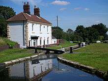
 Tame Valley Junction - the western terminus on the Walsall Canal
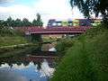 Midland Metro over Tame Valley Canal
 The canal passing over the River Tame
See also
References
- Pearson, Michael (1989). Canal Companion - Birmingham Canal Navigations. J. M. Pearson & Associates. ISBN 0-907864-49-X.
External links
| Wikimedia Commons has media related to Tame Valley Canal. |
Coordinates: 52°32′38″N 1°56′54″W / 52.5438°N 1.94832°W