Digbeth Branch Canal
Digbeth Branch Canal (BCN) | |||||||||||||||||||||||||||||||||||||||||||||||||||||||||||||||||||||||||||||||||||||||||||||||||||||||||||||||||||||||||||||||||||||||||||||||||||||||||||||||||||||||||||||||||||||||||||||||||||||||||||||||||||||||||||||||||||||||||||||||||||||||||||||
|---|---|---|---|---|---|---|---|---|---|---|---|---|---|---|---|---|---|---|---|---|---|---|---|---|---|---|---|---|---|---|---|---|---|---|---|---|---|---|---|---|---|---|---|---|---|---|---|---|---|---|---|---|---|---|---|---|---|---|---|---|---|---|---|---|---|---|---|---|---|---|---|---|---|---|---|---|---|---|---|---|---|---|---|---|---|---|---|---|---|---|---|---|---|---|---|---|---|---|---|---|---|---|---|---|---|---|---|---|---|---|---|---|---|---|---|---|---|---|---|---|---|---|---|---|---|---|---|---|---|---|---|---|---|---|---|---|---|---|---|---|---|---|---|---|---|---|---|---|---|---|---|---|---|---|---|---|---|---|---|---|---|---|---|---|---|---|---|---|---|---|---|---|---|---|---|---|---|---|---|---|---|---|---|---|---|---|---|---|---|---|---|---|---|---|---|---|---|---|---|---|---|---|---|---|---|---|---|---|---|---|---|---|---|---|---|---|---|---|---|---|---|---|---|---|---|---|---|---|---|---|---|---|---|---|---|---|---|---|---|---|---|---|---|---|---|---|---|---|---|---|---|---|---|
Legend
| |||||||||||||||||||||||||||||||||||||||||||||||||||||||||||||||||||||||||||||||||||||||||||||||||||||||||||||||||||||||||||||||||||||||||||||||||||||||||||||||||||||||||||||||||||||||||||||||||||||||||||||||||||||||||||||||||||||||||||||||||||||||||||||
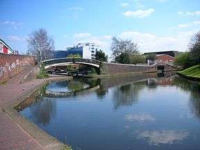


The Digbeth Branch Canal in Birmingham, England is a short canal which links the Birmingham and Fazeley Canal at Aston Junction and the Grand Union Canal at Digbeth Junction (or historically, at the adjacent Warwick Bar) in Digbeth.
Built under the Birmingham Canal Act 1768 and completed in 1799 the Digbeth Branch of the Birmingham Canal Navigations took traffic from the Birmingham and Warwick Junction Canal and the Warwick and Birmingham Canal (now both part of the Grand Union Canal) towards the Worcester and Birmingham Canal at the Worcester Bar (Gas Street Basin).
The 1¼ mile long canal has six locks leading down from Aston Junction. It passes through a grade II listed tunnel at the east of Curzon Street railway station (originally carrying the main lines from it) and under the viaduct of today's eastbound railway line from New Street station. It then originally met the Birmingham and Warwick Junction Canal at the Warwick Bar stop lock just to the rear of Birmingham Proof House, at which there is a short branch to the Typhoo Basin. The junction is called Digbeth Junction or Proof House Junction. It has a total fall of 40 feet.
All of the canal between Ashted Lock at Jennens Road (formerly the A47) and Great Barr Street (Bordesley) is within the Warwick Bar Conservation Area.
Features
| Point | Coordinates |
|---|---|
| Aston Junction | 52°29′25″N 1°53′19″W / 52.49020°N 1.88850°W |
| Ashted Lock | 52°29′10″N 1°53′02″W / 52.48625°N 1.88401°W |
| Ashted tunnel North portal | 52°28′55″N 1°52′55″W / 52.48187°N 1.88191°W |
| Ashted tunnel South portal | 52°28′51″N 1°52′59″W / 52.48080°N 1.88295°W |
| Railway viaduct | 52°28′51″N 1°53′04″W / 52.48082°N 1.88451°W |
| Proof House Junction | 52°28′49″N 1°53′03″W / 52.48028°N 1.88411°W |
| Warwick Bar | 52°28′47″N 1°53′00″W / 52.47985°N 1.88338°W |
| River Rea | 52°28′44″N 1°52′55″W / 52.47897°N 1.88192°W |
| Great Barr Street | 52°28′40″N 1°52′48″W / 52.47783°N 1.87996°W |
| Bordesley Junction | 52°28′32″N 1°52′38″W / 52.47565°N 1.87719°W |
See also
References
- Perrott,David; Mosse,Jonathan (2006). Nicholson Waterways Guide 3 - Birmingham & the Heart of England. Collins. ISBN 978-0-00-721111-1.
- Priestley, Joseph (1831). Historical Account of the Navigable Rivers, Canals, and Railways, Throughout Great Britain. Longman, Rees, Orme, Brown and Green.
External links
- Birmingham City Council - Map of Warwick Bar Conservation Area (PDF)
- Birmingham City Council - Planning Committee designation of Warwick Bar Conservation Area 1987 (PDF)
- Historic England. "Curzon tunnel - grade II (217017)". Images of England.