Bennsville, Maryland
| Bennsville (Bensville), Maryland | |
|---|---|
| Census-designated place | |
 Location of Bennsville, Maryland | |
| Coordinates: 38°37′24″N 77°0′23″W / 38.62333°N 77.00639°WCoordinates: 38°37′24″N 77°0′23″W / 38.62333°N 77.00639°W | |
| Country | United States |
| State | Maryland |
| County | Charles |
| Area | |
| • Total | 16.9 sq mi (43.8 km2) |
| • Land | 16.9 sq mi (43.8 km2) |
| • Water | 0.0 sq mi (0.0 km2) |
| Elevation | 184 ft (56 m) |
| Population (2010) | |
| • Total | 11,923 |
| • Density | 710/sq mi (270/km2) |
| Time zone | Eastern (EST) (UTC-5) |
| • Summer (DST) | EDT (UTC-4) |
| FIPS code | 24-06615 |
| GNIS feature ID | 0589738 |
Bennsville[1] (spelled Bensville by the United States Census Bureau[2]) is a census-designated place (CDP) in Charles County, Maryland, United States. The population was 11,923 at the 2010 census.[3] The area is not an official postal designation, but is part of the Waldorf or Pomfret postal area. The Bennsville area is growing with new residential development, encouraged by the extension in the 1990s of Maryland Route 228 which provides quick access to Maryland Route 210. Bennsville has experienced the 2006 opening of North Point High School and the straightening of Middletown Road in 2008.
Geography
Bennsville is located at 38°37′24″N 77°0′23″W / 38.62333°N 77.00639°W (38.623302, -77.006265).[4]
According to the United States Census Bureau, the CDP has a total area of 16.9 square miles (43.8 km2), an area that consists solely of land.[2]
Demographics
As of the census[5] of 2000, there were 7,325 people, 2,429 households, and 2,071 families residing in the CDP. The population density was 431.6 people per square mile (166.7/km²). There were 2,493 housing units at an average density of 146.9/sq mi (56.7/km²). The racial makeup of the CDP was 76.46% White, 18.02% African American, 0.41% Native American, 2.32% Asian, 0.10% Pacific Islander, 0.55% from other races, and 2.14% from two or more races. Hispanic or Latino of any race were 2.20% of the population.
There were 2,429 households out of which 43.4% had children under the age of 18 living with them, 74.9% were married couples living together, 7.5% had a female householder with no husband present, and 14.7% were non-families. 10.5% of all households were made up of individuals and 2.1% had someone living alone who was 65 years of age or older. The average household size was 3.01 and the average family size was 3.25.
In the CDP the population was spread out with 28.1% under the age of 18, 6.8% from 18 to 24, 32.5% from 25 to 44, 27.4% from 45 to 64, and 5.3% who were 65 years of age or older. The median age was 36 years. For every 100 females there were 97.5 males. For every 100 females age 18 and over, there were 97.3 males.
The median income for a household in the CDP was $83,388, and the median income for a family was $85,988. Males had a median income of $51,770 versus $39,797 for females. The per capita income for the CDP was $29,677. About 0.4% of families and 1.5% of the population were below the poverty line, including none of those under age 18 and 5.5% of those age 65 or over.
References
- ↑ U.S. Geological Survey Geographic Names Information System: Bennsville, Maryland
- 1 2 "Geographic Identifiers: 2010 Demographic Profile Data (DP-1): Bensville CDP, Maryland". U.S. Census Bureau, American Factfinder. Archived from the original on September 11, 2013. Retrieved August 3, 2012.
- ↑ "Profile of General Population and Housing Characteristics: 2010 Demographic Profile Data (DP-1): Bensville CDP, Maryland". U.S. Census Bureau, American Factfinder. Archived from the original on September 11, 2013. Retrieved August 3, 2012.
- ↑ "US Gazetteer files: 2010, 2000, and 1990". United States Census Bureau. 2011-02-12. Retrieved 2011-04-23.
- ↑ "American FactFinder". United States Census Bureau. Archived from the original on 2013-09-11. Retrieved 2008-01-31.
Municipalities and communities of Charles County, Maryland, United States | ||
|---|---|---|
| Towns | 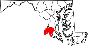 | |
| CDPs | ||
| Other communities | ||
| Principal cities |
| |||||||||||
|---|---|---|---|---|---|---|---|---|---|---|---|---|
| Counties and county equivalents* |
| |||||||||||
The District of Columbia itself, and Virginia's incorporated cities, are county equivalents. Virginia's incorporated cities are listed under their surrounding county. The incorporated cities bordering more than one county (Alexandria, Falls Church and Fredericksburg) are listed under the county they were part of before incorporation as a city. | ||||||||||||