Fredericksburg, Virginia
| Fredericksburg, Virginia | |||||
|---|---|---|---|---|---|
| Independent city | |||||
| City of Fredericksburg | |||||
|
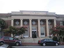
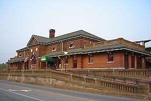
Historic downtown Fredericksburg | |||||
| |||||
| Motto: America's Most Historic City | |||||
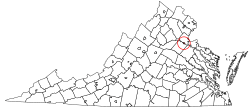 Location in Virginia | |||||
 Location of Virginia in the United States | |||||
| Coordinates: 38°18′6.5″N 77°28′15″W / 38.301806°N 77.47083°W | |||||
| Country | United States | ||||
| State | Virginia | ||||
| County | None (Independent city) | ||||
| Founded | 1728 | ||||
| Incorporated | 1781 | ||||
| Government | |||||
| • Mayor | Mary Katherine Greenlaw | ||||
| Area | |||||
| • Total | 10.5 sq mi (27.2 km2) | ||||
| • Land | 10.4 sq mi (27.0 km2) | ||||
| • Water | 0.08 sq mi (0.2 km2) | ||||
| Elevation | 59 ft (18 m) | ||||
| Population (2010)[1] | |||||
| • Total | 24,286 | ||||
| • Estimate (2015)[2] | 28,118 | ||||
| • Density | 2,326/sq mi (898.2/km2) | ||||
| Time zone | Eastern (EST) (UTC-5) | ||||
| • Summer (DST) | EDT (UTC-4) | ||||
| ZIP codes | 22401–22404 (4 total) | ||||
| Area code(s) | 540 | ||||
| FIPS code | 51-29744[3] | ||||
| GNIS feature ID | 1494947[4] | ||||
| Website |
www | ||||
| * Independent from Spotsylvania County in 1879 | |||||


Fredericksburg is an independent city in Virginia, United States. As of the 2010 census, the population was 24,286,[1] up from 19,279 at the 2000 census. The city population was estimated at 28,118 in 2015.[2] The Bureau of Economic Analysis combines the city of Fredericksburg with neighboring Spotsylvania County for statistical purposes.
Located 47 miles (76 km) south of Washington, D.C. and 56 miles (90 km) north of Richmond, Fredericksburg is part of the Northern Virginia region[5][6] and is included in the Washington-Arlington-Alexandria, DC-VA-MD-WV Metropolitan Statistical Area.
Located near where the Rappahannock River crosses the Fall Line, Fredericksburg was a prominent port in Virginia during the colonial era. During the Civil War, the town, located halfway between the capitals of the opposing forces, was the site of the Battle of Fredericksburg and Second Battle of Fredericksburg, preserved in part as the Fredericksburg and Spotsylvania National Military Park. Tourism is a major part of the economy, with approximately 1.5 million people visiting the Fredericksburg area annually, including the battlefield park, the downtown visitor center, events, museums and historic sites.[7]
Fredericksburg is home to several major commercial centers including Central Park (as of 2004, the second-largest mall on the East Coast) and Spotsylvania Towne Centre, located in Spotsylvania County adjacent to the city line. Major employers include the University of Mary Washington, Mary Washington Healthcare, and GEICO. Many Fredericksburg-area residents commute to work by car, bus, and rail to Washington and Richmond, as well as Fairfax, Prince William, and Arlington counties.[8][9][10][11]
History
At the time of European encounter, the inhabitants of the area that became Fredericksburg were a Siouan-speaking tribe called the Manahoac. English colonists recorded the name of the Manahoac village there as Mahaskahod.[12]
Colonial
Located on the Rappahannock River near the head of navigation at the fall line, Fredericksburg developed as the frontier of colonial Virginia shifted west out of the coastal plain. The land on which the city was founded was part of a tract patented in 1671. The Virginia General Assembly established a fort on the Rappahannock in 1676, just below the present-day city. In 1714, Lt. Gov. Alexander Spotswood sponsored a German settlement called Germanna on the Rapidan River, a tributary of the Rappahannock upstream from the future site of the city, and led an expedition westward over the Blue Ridge Mountains in 1716.
As interest in the frontier grew, the colonial assembly responded by forming a new county named Spotsylvania (after Alexander Spotswood, the governor at the time) in 1720 and establishing Fredericksburg in 1728 as a port for the county, of which it was then a part. Named for Frederick, Prince of Wales,[13] son of King George II, the colonial town's streets bore the names of members of the royal family. The county court was moved to Fredericksburg in 1732, and the town served as county seat until 1780, when the courthouse was moved closer to the county center in Spotsylvania County. In 1781, Fredericksburg was incorporated as a town, with its own court, council, and mayor. It received its charter as a city in 1879, and under Virginia law was separated from Spotsylvania County. The city adopted its present city manager/council form of government in 1911.
The city has close associations with George Washington, whose family moved to Ferry Farm in Stafford County just off the Rappahannock River opposite Fredericksburg in 1738. Washington's mother Mary later moved to the city, and his sister Betty lived at Kenmore, a plantation house then outside the city. Other significant early residents include the Revolutionary War generals Hugh Mercer and George Weedon, naval war hero John Paul Jones, and future U.S. president James Monroe. Thomas Jefferson wrote the Virginia Statute for Religious Freedom in Fredericksburg.
19th century
During the 19th century, Fredericksburg sought to maintain its sphere of trade, but with limited success. It promoted the development of a canal on the Rappahannock and construction of a turnpike and plank road to bind the interior country to the market town. By 1837, a north-south railroad, which became the Richmond, Fredericksburg and Potomac Railroad, linked the town to Richmond, the state capital. A much-needed railroad joining the town to the farming region to the west was not finished until after the Civil War.
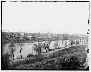
During the Civil War, Fredericksburg gained strategic importance due to its location midway between Washington and Richmond, the opposing capitals of the Union and the Confederacy. During the Battle of Fredericksburg, December 11–15, 1862, the town sustained significant damage from bombardment and looting by the Union forces. A Second Battle of Fredericksburg was fought in and around the town on May 3, 1863, in connection with the Chancellorsville campaign (April 27, 1863 – May 6, 1863). The battles of the Wilderness and Spotsylvania Court House were fought nearby in May 1864.
20th century
After the war, Fredericksburg recovered its former position as a center of local trade and slowly grew beyond its prewar boundaries. Neither the city of Fredericksburg, nor either of the surrounding counties, reached the population level of the census of 1860 until the 1940s (spurred by World War II). The 1960s brought renewed growth and development, fueled by the "arrival" of Interstate 95. By the 1970s, the city and the area had become a bedroom community for jobs in Northern Virginia and Washington, D.C., largely related to the city's location near four military installations: Quantico Marine Corps Base, the Army's Fort Belvoir, the Navy's Dahlgren Surface Weapons Base, and the National Guard's Fort A.P. Hill. In addition, career military personnel, assigned to the Pentagon (in Arlington, Virginia), find Fredericksburg a convenient home base.
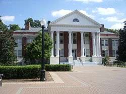
The University of Mary Washington was founded in Fredericksburg in 1908 as the State Normal and Industrial School for Women. Adopting the name of Mary Washington College in 1938, the college was for many years associated with the University of Virginia as a women's liberal arts college. The college became independent of UVA and began to accept men in 1970. Recently, the college changed names from Mary Washington College to the University of Mary Washington. Two separate campuses for graduate and professional studies and education and research are located in suburban Stafford County and in rural King George County near the Dahlgren naval base, respectively.
The power chord of modern guitar was first developed by Link Wray in Fredericksburg in 1958 during his first improvisation of the instrumental piece "Rumble", a single released by Wray & His Ray Men.[14] The local music scene includes a wide variety of genres.
A commuter rail line – the Virginia Railway Express – was established in the 1980s, providing passage to job sites north of Fredericksburg.
The city has become the regional healthcare center for the area. Retail, real estate, and other commercial growth exploded into the early 21st century, eventually slowing during the "Great Recession" beginning in 2007.
Geography and climate
According to the United States Census Bureau, the city has a total area of 10.5 square miles (27.2 km2), of which 10.4 square miles (27.0 km2) is land and 0.1 square miles (0.2 km2), or 0.67%, is water.[15] The city is part of the boundary between the Piedmont and Tidewater regions, and as such is located on the fall line, as evident on the Rappahannock River. US 1, US 17, and I-95 all pass through the city, which is located 53 miles (85 km) south of downtown Washington, D.C.
The city is bounded on the north and east by the Rappahannock River; across the river is Stafford County. The city is bounded on the south and west by Spotsylvania County.
Fredericksburg has a four-season humid subtropical climate (Köppen Cfa), with cool winters and hot, humid summers. Daytime temperatures for much of the year average slightly higher than in Washington, DC due to the southerly aspect, although the inland location and distance from the urban heat island present in the nation's capital make for significantly cooler low temperatures.
| Climate data for Fredericksburg, Virginia (downtown, 1981−2010 normals) | |||||||||||||
|---|---|---|---|---|---|---|---|---|---|---|---|---|---|
| Month | Jan | Feb | Mar | Apr | May | Jun | Jul | Aug | Sep | Oct | Nov | Dec | Year |
| Average high °F (°C) | 45.3 (7.4) |
48.7 (9.3) |
56.9 (13.8) |
67.5 (19.7) |
75.9 (24.4) |
84.5 (29.2) |
87.8 (31) |
86.5 (30.3) |
80.0 (26.7) |
69.9 (21.1) |
59.4 (15.2) |
49.0 (9.4) |
67.7 (19.8) |
| Average low °F (°C) | 24.3 (−4.3) |
26.1 (−3.3) |
33.2 (0.7) |
43.0 (6.1) |
52.4 (11.3) |
62.5 (16.9) |
67.1 (19.5) |
65.7 (18.7) |
58.0 (14.4) |
44.9 (7.2) |
35.6 (2) |
27.3 (−2.6) |
45.1 (7.3) |
| Average precipitation inches (mm) | 2.90 (73.7) |
2.51 (63.8) |
3.99 (101.3) |
3.35 (85.1) |
4.08 (103.6) |
3.97 (100.8) |
4.53 (115.1) |
3.39 (86.1) |
4.32 (109.7) |
3.38 (85.9) |
3.75 (95.3) |
3.18 (80.8) |
43.35 (1,101.2) |
| Average precipitation days (≥ 0.01 in) | 9.5 | 10.1 | 11.4 | 11.7 | 12.5 | 10.2 | 13.1 | 10.0 | 9.4 | 8.8 | 9.8 | 11.2 | 127.7 |
| Source: NOAA (precipitation days at Fredericksburg National Battlefield Park)[16][17] | |||||||||||||
Demographics
| Historical population | |||
|---|---|---|---|
| Census | Pop. | %± | |
| 1830 | 3,308 | — | |
| 1840 | 3,974 | 20.1% | |
| 1850 | 4,061 | 2.2% | |
| 1860 | 5,022 | 23.7% | |
| 1870 | 4,046 | −19.4% | |
| 1880 | 5,010 | 23.8% | |
| 1890 | 4,528 | −9.6% | |
| 1900 | 5,068 | 11.9% | |
| 1910 | 5,874 | 15.9% | |
| 1920 | 5,882 | 0.1% | |
| 1930 | 6,819 | 15.9% | |
| 1940 | 10,066 | 47.6% | |
| 1950 | 12,158 | 20.8% | |
| 1960 | 13,639 | 12.2% | |
| 1970 | 14,450 | 5.9% | |
| 1980 | 15,322 | 6.0% | |
| 1990 | 19,027 | 24.2% | |
| 2000 | 19,279 | 1.3% | |
| 2010 | 24,286 | 26.0% | |
| Est. 2015 | 28,118 | [2] | 15.8% |
| U.S. Decennial Census[18] 1790–1960[19] 1900–1990[20] 1990–2000[21] 2010–2013[22] | |||

|
|
| ||||||||||||||||||||||||||||||||||||||||||||||||||||||||||||||||||||||||
As of the census[26] of 2000, there were 19,279 people, 8,102 households, and 3,925 families residing in the city. The population density was 1,833.0 people per square mile (707.6/km²). There were 8,888 housing units at an average density of 845.0 per square mile (326.2/km²). The racial makeup of the city was 73.18% White, 20.41% Black or African American, 0.34% Native American, 1.51% Asian, 0.06% Pacific Islander, 2.56% from other races, and 1.95% from two or more races. 4.90% of the population were Hispanic or Latino of any race.
There were 8,102 households out of which 21.6% had children under the age of 18 living with them, 31.8% were married couples living together, 13.1% had a female householder with no husband present, and 51.6% were non-families. 39.2% of all households were made up of individuals and 12.8% had someone living alone who was 65 years of age or older. The average household size was 2.09 and the average family size was 2.81.
In the city the population was spread out with 17.8% under the age of 18, 23.8% from 18 to 24, 27.2% from 25 to 44, 18.4% from 45 to 64, and 12.8% who were 65 years of age or older. The median age was 30 years. For every 100 females there were 81.8 males. For every 100 females age 18 and over, there were 78.4 males.
The median income for a household in the city was $34,585, and the median income for a family was $47,148. Males had a median income of $33,641 versus $25,037 for females. The per capita income for the city was $21,527. 15.5% of the population and 10.4% of families were below the poverty line. Out of the total population, 19.9% of those under the age of 18 and 8.8% of those 65 and older were living below the poverty line.
Crime
The Fredericksburg Police Department tracks crime information under the state-level system of the Uniform Crime Reporting program.[note 1] Per state code, the central repository for crime statistics rests with the Department of State Police, which compiles data from all of the participating agencies into an annual publication.[27]
Politics
By long-standing tradition (dating back to the Federal "Hatch Act" which prohibited government employees from participating in "partisan" politics'), local elections in Fredericksburg are officially non-partisan. Neither the mayoral and council elections nor local constitutional positions (e.g. sheriff, Commissioner of Revenue, Commonwealth Attorney) list candidates with a party label.
Like the rest of Northern Virginia, Fredericksburg has trended strongly Democratic in recent years. In the 2008 presidential election, voters in Fredericksburg gave Barack Obama a total of 64.33% of the vote.[28] Only Arlington County, Alexandria, and Falls Church had a higher percentage of votes for Obama in Northern Virginia.[28] According to Dave Leip's Atlas of U.S. Presidential Elections, no Republican presidential candidate has carried Fredericksburg since 1988.
Mayor Mary Katherine Greenlaw won election in 2012[29] and was reelected in 2016.[30]
Culture and recreation
Architecture and historic sites
|
Fredericksburg Historic District | |
 | |
| Location |
Roughly bounded by Rappahannock River, Hazel Run, Prince Edward and Canal Sts., Fredericksburg, Virginia |
|---|---|
| Area | 200 acres (81 ha) |
| NRHP Reference # | [31] |
| VLR # | 111-0132 |
| Significant dates | |
| Added to NRHP | September 22, 1971 |
| Designated VLR | March 2, 1971[32] |
Despite recent decades of suburban growth, reminders of the area's past abound. The 40-block Fredericksburg Historic District, on the National Register of Historic Places, embraces the city's downtown area and contains more than 350 buildings dating to the 18th and 19th centuries. Crowds of tourists are drawn to the historic district of Fredericksburg during the summer months.
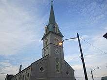
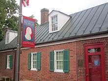
Within the historic district, four 18th-century historic sites have been managed by Preservation Virginia but, following a full, statewide reorganization by that organization, the newly created "Washington Heritage Museums" group will acquire the sites by 2014: the Mary Washington House, where George Washington's mother spent her final years; the late 18th century Rising Sun Tavern and the Hugh Mercer Apothecary Shop (the fourth is only open on Historic Garden Week). Important public buildings include the 1852 courthouse designed by James Renwick, whose works include the Smithsonian Institution's castle building in Washington and St. Patrick's Cathedral in New York City, and the 1816 town hall and market house. The latter building housed the Fredericksburg Area Museum and Cultural Center which was closed in 2015 due to a lack of funding. Another site of interest is St. George's Church. The James Monroe Museum and Memorial Library is located on the site where Monroe practiced law from 1786 to 1788. The museum is housed in a building that is made up of three individual structures, constructed at different times, beginning in 1816.
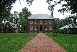
Nearby the historic district is Kenmore, the plantation home of Washington's sister Betty and her husband patriot Fielding Lewis.
The area's Civil War battles are commemorated in Fredericksburg and Spotsylvania National Military Park. Formed by an act of Congress in 1927, the national military park preserves portions of the battlefields of Fredericksburg, Chancellorsville, the Wilderness, and Spotsylvania Court House. The Fredericksburg National Cemetery, also part of the park, is located on Marye's Heights on the Fredericksburg battlefield and contains more than 15,000 Union burials from the area's battlefields.
Notable 20th-century sites and structures include the campus of the University of Mary Washington (begun in 1908), and Carl's Ice Cream, an Art Moderne roadside ice cream stand on the National Register of Historic Places on U.S. Route 1.
Nearby points of interest include Ferry Farm historic site in Stafford County where Washington spent his boyhood immediately across the river from Fredericksburg, and the George Washington Birthplace National Monument, located 38 miles to the east in Westmoreland County. The historic community of Falmouth lies across the Rappahannock to the north and includes the historic house Belmont, home of American Impressionist artist Gari Melchers.
Parks
Public parks run by the city include:[33]
- Old Mill Park
- Alum Spring Park[34]
- Hurkamp Park
- Dixon Park
Public Library
Central Rappahannock Regional Library
Education
Primary and secondary schools
The Fredericksburg City Public Schools are run independent of the surrounding counties. The public primary and secondary schools include:[35]
- James Monroe High School
- Walker-Grant Middle School
- Hugh Mercer
- Lafayette Upper Elementary School
Private schools include:
- Fredericksburg Academy
- Fredericksburg Christian School
- Saint Michael the Archangel High School
- Lighthouse Academy
Higher education
The University of Mary Washington, established in 1908 and opening in 1911, is a four-year public university within the city.
Media
Fredericksburg's daily newspaper is The Free Lance–Star. The Free Lance was first published in 1885, and competed with two twice-weekly papers in the city during the late 19th century, the Fredericksburg News and The Virginia Star. While the News folded in 1884, the Star moved to daily publication in 1893. In 1900, the two companies merged, with both newspapers continuing publication until 1926, when they merged as a single daily newspaper under the current title. Until June 19, 2014, the Free Lance–Star was owned and operated by members of the Rowe family of Fredericksburg. At that time, Sandton Capital Partners purchased the paper. On December 31, 2015 the newspaper and associated website were purchased by Berkshire Hathaway′s BH Media Group.[36] Fredericksburg.Today, an online hyperlocal news site began operation following the 2014 bankruptcy of The Free Lance–Star.[37]
Fredericksburg and the nearby region have several radio stations, including (on the FM dial) WYAU (89.5, Public Radio), WJYJ (90.5, Christian), WFLS (93.3, country), WGRQ (95.9, "SuperHits", licensed to nearby Fairview Beach), WWUZ (96.9, classic rock, licensed to nearby Bowling Green), WVBX (99.3, "The Vibe", rhythmic contemporary, licensed to nearby Spotsylvania), WBQB ("B-101.5", adult contemporary) and WGRX ("Thunder 104.5", country, licensed to nearby Falmouth). Fredericksburg AM stations include WFVA (1230, nostalgia) and WNTX (1350, talk, news, and sports). WGRQ and WGRX are owned locally by Telemedia Broadcasting. WFLS, WWUZ, WVBX, and WYSK are owned by Alpha Media.
In 2001, the Arbitron media service began listing the Fredericksburg area as a nationally rated radio market. As of the fall of 2014, the area ranked 146th out of 272 markets surveyed, with a total market population of more than 325,000. Large broadcast companies like Clear Channel Communications and Cumulus Broadcasting are not active in the local market; almost all of its stations remain locally or regionally owned.
In television, Fredericksburg is part of the Washington market. One local television station, NBC affiliate WHFV, was briefly on the air in the 1970s.
Sports
There are no professional sports teams in Fredericksburg. In October 2013, the Hagerstown Suns minor league baseball team formally applied to relocate there for the 2015 season,[38] but plans fell apart by November 2014.[39]
Sports at the secondary education level are run through the Virginia High School League. On the collegiate level are the University of Mary Washington Eagles. Other amateur athletics include the Fredericksburg Hotspur[40] of United Soccer Leagues Premier Development League (PDL); the Virginia Badgers of American Indoor Football (AIF); and the Rappahannock Rugby Club, a senior men's rugby club competing in Division III of the Potomac Rugby Union.
Transportation
Fredericksburg is traversed by a series of rural and suburban four-lane highways and a multitude of small, two-lane roads. Among the major arterial roads is U.S. Route 1, providing north-south transportation from the region to Stafford County, Washington D.C., and points beyond. Route 3 (Plank Road) is a major east-west route that connects downtown Fredericksburg (via the Blue and Gray Parkway bypass), southern Stafford and King George counties, and Route 301 to the east with the large shopping centers, Spotsylvania Town Center and Central Park. To the west, Route 3 reaches Culpeper, where it meets Route 29 and Route 15.
Most of Fredericksburg's traffic flow is to or from the north (Washington D.C. metropolitan area) during peak commuting hours, primarily via Interstate 95 and US-1. The US-1 bridge over the Rappahannock River is often a traffic bottleneck, and Route 3 has become increasingly jammed as residential development has grown west, along with a major regional shopping center.
As an alternative to I-95, some commuters use the Virginia Railway Express rail service to Washington. Long-distance rail service is available on Amtrak, which serves Fredericksburg via the Northeast Regional and Carolinian/Piedmont routes. Fredericksburg Regional Transit (FRED) is a recently started bus service in Fredericksburg which serves most area communities, retail shopping centers, two VRE stations, and downtown Fredericksburg.
Notable people


18th century and before
- Lewis Craig (brother of Elijah Craig), Baptist preacher imprisoned for religious freedom issues before the American Revolution;[41] leader of The Travelling Church that migrated to Kentucky (see History of Baptists in Kentucky)
- Henry Crist, former congressman from Kentucky
- John Paul Jones, American naval commander
- Fielding Lewis and Elizabeth "Betty" Washington, brother-in-law and sister of George Washington
- Hugh Mercer, soldier and physician
- James Monroe, fifth president of the United States
- Augustine Washington, father of George Washington
- George Washington, first president of the United States, leader of the American Revolutionary War
- Mary Ball Washington, mother of George Washington
- George Weedon, brigadier general in the Continental Army
19th century to present
- Oliver Ackermann, guitarist and vocalist for A Place to Bury Strangers
- Urbane F. Bass, doctor and Army officer during WWI
- Julien Binford, artist
- Al Bumbry, baseball player[42]
- Jermon Bushrod, NFL player drafted by the New Orleans Saints (#125th pick) in 2007 draft[43]
- Caressa Cameron, Miss America 2010
- George Coghill, retired defensive back for the Denver Broncos[44]
- Bill Crawley, historian
- James L. Farmer, Jr., civil rights leader
- Derek Hartley, radio show host
- Kelvin Jones, professional soccer player
- Eli Kim, rapper in the Korean pop group U-KISS
- Florence King, author of Southern Ladies and Gentlemen and Confessions of a Failed Southern Lady
- Mark Lenzi, Olympic diver and gold medalist
- John Maine, New York Mets starting pitcher[45]
- Danny McBride, actor[46]
- Erin McKeown, musician
- George P. McLain (1847–1930), Los Angeles City Council member at the turn of the 19th-20th centuries
- George C. Rawlings, Virginia House of Delegates
- Judge Reinhold, actor
- Jeff Rouse, Olympic swimmer, gold medalist and former world record holder
- Dave Smalley, musician, member of All, Dag Nasty, Down by Law, The Sharpshooters
- Torrey Smith, NFL football player
- William P. Taylor, congressman
- Keller Williams, musician
- Monty Williams, basketball player
Sister cities
Footnotes
- ↑ The Uniform Crime Reporting program was developed and is administered by the Federal Bureau of Investigation. It provides a nationwide view of crime based on the submission of statistical data from law enforcement agencies across the country. The crime information is collected under the National Incident Based Reporting System format
- ↑ Sometimes mistakenly labeled as taken in the field after the Battle of Chancellorsville, May 2, 1863.
- ↑ Sometimes mistakenly labeled as taken at siege of Petersburg, Virginia.
References
- 1 2 "Geographic Identifiers: 2010 Demographic Profile Data (G001): Fredericksburg city, Virginia". U.S. Census Bureau, American Factfinder. Retrieved October 20, 2016.
- 1 2 3 "Annual Estimates of the Resident Population for Incorporated Places: April 1, 2010 to July 1, 2015". Retrieved July 2, 2016.
- ↑ "American FactFinder". United States Census Bureau. Retrieved 2008-01-31.
- ↑ "US Board on Geographic Names". United States Geological Survey. 2007-10-25. Retrieved 2008-01-31.
- ↑ "Metropolitan and NECMA Counties in Alphabetical Order, by State, with Area Titles". U.S. Census Bureau. Retrieved 2015-01-10.
- ↑ "Fredericksburg Overview". Virginia Tourism Corporation. Retrieved 2015-01-10.
- ↑ Official website of the city of Fredericksburg, Virginia
- ↑ Owen, Karen (May 11, 2008). "Are we Northern Virginia?". The Free Lance–Star. Retrieved October 24, 2008.
- ↑ Kelly, Matthew (May 11, 2008). "We can avoid the circle of Hell". The Free Lance–Star. Retrieved October 24, 2008.
- ↑ Connors, Hap (May 11, 2008). "A 'tweener': We must play smart". The Free Lance–Star. Retrieved October 24, 2008.
- ↑ Farley, Catherine A. (May 11, 2008). "Robert E. Lee might not recognize the place". The Free Lance–Star. Retrieved October 24, 2008.
- ↑ Swanton, John R. (1952), The Indian Tribes of North America, Smithsonian Institution, pp. 61–62, ISBN 0-8063-1730-2, OCLC 52230544
- ↑ Gannett, Henry (1905). The Origin of Certain Place Names in the United States. Govt. Print. Off. p. 131.
- ↑ Harrington, Richard (November 22, 2005). "Prophet of the Rock Guitar". The Washington Post. Retrieved October 24, 2008.
- ↑ "US Gazetteer files: 2010, 2000, and 1990". United States Census Bureau. 2011-02-12. Retrieved 2011-04-23.
- ↑ "Station Name: VA FREDERICKSBURG SEWAGE". National Oceanic and Atmospheric Administration. Retrieved 2013-02-28.
- ↑ "Station Name: VA FREDERICKSBURG NP". National Oceanic and Atmospheric Administration. Retrieved 2013-02-28.
- ↑ "U.S. Decennial Census". United States Census Bureau. Retrieved January 6, 2014.
- ↑ "Historical Census Browser". University of Virginia Library. Retrieved January 6, 2014.
- ↑ "Population of Counties by Decennial Census: 1900 to 1990". United States Census Bureau. Retrieved January 6, 2014.
- ↑ "Census 2000 PHC-T-4. Ranking Tables for Counties: 1990 and 2000" (PDF). United States Census Bureau. Retrieved January 6, 2014.
- ↑ "State & County QuickFacts". United States Census Bureau. Retrieved January 6, 2014.
- ↑ "American Factfinder, Community Facts, Fredericksburg city, Virginia, Origins and Language, Census 2000, Selected Social Characteristics (Household and Family Type, Disability, Citizenship, Ancestry, Language, ...)". U.S. Census Bureau. Retrieved July 1, 2016.
- ↑ "American Factfinder, Community Facts, Fredericksburg city, Virginia, Origins and Language, 2014 American Community Survey, Selected Social Characteristics (Household and Family Type, Disability, Citizenship, Ancestry, Language, ...), 2010". U.S. Census Bureau. Retrieved July 1, 2016.
- ↑ "American Factfinder, Community Facts, Fredericksburg city, Virginia, Origins and Language, 2014 American Community Survey, Selected Social Characteristics (Household and Family Type, Disability, Citizenship, Ancestry, Language, ...)". U.S. Census Bureau. Retrieved July 1, 2016.
- ↑ "American FactFinder". United States Census Bureau. Retrieved 2011-05-14.
- ↑ Crime in Virginia 2011
- 1 2 "2008 Presidential Election Results By County". The New York Times. December 9, 2008. Retrieved April 6, 2012.
- ↑ Sidersky, Robyn (May 1, 2012). "Greenlaw, Kelly, Devine win Fredericksburg elections". The Free Lance-Star. The Free Lance-Star Publishing. Retrieved March 24, 2014.
- ↑ "Mary Katherine Greenlaw wins a second term as Fredericksburg mayor". Fredericksburg.com. Retrieved 2016-05-27.
- ↑ National Park Service (2010-07-09). "National Register Information System". National Register of Historic Places. National Park Service.
- ↑ "Virginia Landmarks Register". Virginia Department of Historic Resources. Retrieved 19 March 2013.
- ↑ "map of parks in Fredericksburg VA" (PDF). Fredericksburg City Parks and Recreation. Retrieved 28 July 2011.
- ↑ Crookshanks, Barbara (October 28, 2004). "Alum Spring Park: A Walk Through History". Historypoint.org. The Central Rappahannock Regional Library. Archived from the original on November 13, 2004.
- ↑ "homepage". Fredericksburg City Public Schools. Retrieved 28 July 2011.
- ↑ "Berkshire Hathaway Buys Newspaper in Fredericksburg, Virginia". Bloomberg News. 31 December 2015. Retrieved 4 January 2016.
- ↑ "Patch Lays off Hundreds, Shuttered Editor to Start Indie News Site". PotomacLocal.com. 30 January 2014. Retrieved 4 January 2016.
- ↑ Freehling, Bill (1 October 2013). "Hagerstown Suns apply to relocate to Fredericksburg". Business Insider. Fredericksburg.com. Retrieved 23 October 2013.
- ↑ Gould, Pamela (November 25, 2014). "Baseball deal out in city". Fredericksburg.com. Fredericksburg Free Lance-Star. Retrieved January 12, 2015.
- ↑ The Gunners were founded 2006 and folded in 2010, Fredericksburg Hotspur
- ↑ "For Area Baptists: The First Hundred Years Were the Hardest". Town & County. The Free Lance-Star. 83 (272). November 8, 1967. p. A-3. Retrieved July 1, 2016.
- ↑ "Al Bumbry Stats". Baseball Almanac. Retrieved November 6, 2012.
- ↑ "Jermon Bushrod". SI.com. Retrieved November 6, 2012.
- ↑ "George Webster Coghill". databaseFootball.com. Retrieved November 6, 2012.
- ↑ "John Maine Stats". Baseball Almanac. Retrieved November 6, 2012.
- ↑ Hedelt, Rob (January 24, 2008). "Movie, TV projects fall in line for local native". fredericksburg.com. The Free Lance-Star. Retrieved 2009-02-10.
- ↑ "Why Italian Flags Downtown?". WFVA. June 17, 2015. Retrieved June 18, 2015.
A delegation from Este, Italy is here. They are the city’s newest sister city.
- ↑ Larson, Susan (December 17, 2012). "City Adds Schwetzingen, Germany as Sister City". Fredericksburg Patch. Retrieved September 27, 2013.
External links
| Wikimedia Commons has media related to Fredericksburg, Virginia. |
| Wikivoyage has a travel guide for Fredericksburg, Virginia. |
| Wikisource has the text of a 1906 New International Encyclopedia article about Fredericksburg, Virginia. |
| Wikisource has original text related to this article: |
- Official website
- General Interest Information about Fredericksburg Virginia
- Local history resources from the Central Rappahannock Regional Library
- Fredericksburg.com, the website of the Free Lance-Star newspaper
- Daily Star, Google news archive. —PDFs for 7,659 issues, dating from 1893 through 1926.
- U.S. National Slavery Museum
- Central Rappahannock Heritage Center a nonprofit all volunteer historical archive in Fredericksburg, Virginia.
- U.S. Geological Survey Geographic Names Information System: Fredericksburg, Virginia
Coordinates: 38°18′07″N 77°28′15″W / 38.301829°N 77.470778°W
 |
Stafford County | | ||
| Spotsylvania County | |
Stafford County | ||
| ||||
| | ||||
| Spotsylvania County |
| Principal cities |
| |||||||||||
|---|---|---|---|---|---|---|---|---|---|---|---|---|
| Counties and county equivalents* |
| |||||||||||
The District of Columbia itself, and Virginia's incorporated cities, are county equivalents. Virginia's incorporated cities are listed under their surrounding county. The incorporated cities bordering more than one county (Alexandria, Falls Church and Fredericksburg) are listed under the county they were part of before incorporation as a city. | ||||||||||||