Manassas Park, Virginia
| Manassas Park, Virginia | ||
|---|---|---|
| Independent city | ||
| City of Manassas Park | ||
|
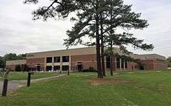
Manassas Park community center | ||
| ||
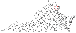 Location in relation to Prince William County and the state of Virginia. | ||
| Coordinates: 38°46′24″N 77°27′12″W / 38.77333°N 77.45333°W | ||
| Country | United States | |
| State | Virginia | |
| County | None (Independent city) | |
| Incorporated | 1975 | |
| Government | ||
| • Mayor | Frank Jones | |
| Area | ||
| • Total | 2.5 sq mi (6 km2) | |
| • Land | 2.5 sq mi (6 km2) | |
| • Water | 0.0 sq mi (0 km2) | |
| Population (2010) | ||
| • Total | 14,273 | |
| • Density | 5,642/sq mi (2,178/km2) | |
| FIPS code | 51-48968[1] | |
| GNIS feature ID | 1495894[2] | |
| Website | City of Manassas Park | |

Manassas Park is an independent city in the U.S. state of Virginia. As of the 2010 census, the population was 14,273.[3] Manassas Park is bordered by the city of Manassas and Prince William County. Manassas Park is a part of the Washington-Arlington-Alexandria, DC-VA-MD-WV Metropolitan Statistical Area.
History
Manassas Park was incorporated as a town in 1957 and incorporated as a city in 1975.
Conner House and the Louisiana Brigade Winter Camp are listed on the National Register of Historic Places.[4]
Adjacent county / Independent city
Demographics
| Historical population | |||
|---|---|---|---|
| Census | Pop. | %± | |
| 1970 | 6,844 | — | |
| 1980 | 6,524 | −4.7% | |
| 1990 | 6,734 | 3.2% | |
| 2000 | 10,290 | 52.8% | |
| 2010 | 14,273 | 38.7% | |
| Est. 2015 | 15,726 | [5] | 10.2% |
| U.S. Decennial Census[6] 1790-1960[7] 1900-1990[8] 1990-2000[9] 2010-2013[3] | |||
According to the census[10] of 2010, there were 14,273 people. The racial makeup of the city was 43% White, 13% African American, 9% Asian, Hispanic or Latino were 33% of the population.
Education
The city is served by Manassas Park City Schools, with a total of 4 schools: Cougar Elementary, Manassas Park Elementary, Manassas Park Middle, and Manassas Park High School.
Law enforcement
The Manassas Park Police Department offers many services, including animal control, a narcotics and gang task force.
Notable residents
- Johnny Micheal Spann, was an employee of the Central Intelligence Agency (CIA) and the first American killed in combat after the U.S. invasion of Afghanistan.
References
- ↑ "American FactFinder". United States Census Bureau. Retrieved 2008-01-31.
- ↑ "US Board on Geographic Names". United States Geological Survey. 2007-10-25. Retrieved 2008-01-31.
- 1 2 "State & County QuickFacts". United States Census Bureau. Retrieved January 6, 2014.
- ↑ National Park Service (2010-07-09). "National Register Information System". National Register of Historic Places. National Park Service.
- ↑ "Annual Estimates of the Resident Population for Incorporated Places: April 1, 2010 to July 1, 2015". Retrieved July 2, 2016.
- ↑ "U.S. Decennial Census". United States Census Bureau. Retrieved January 6, 2014.
- ↑ "Historical Census Browser". University of Virginia Library. Retrieved January 6, 2014.
- ↑ "Population of Counties by Decennial Census: 1900 to 1990". United States Census Bureau. Retrieved January 6, 2014.
- ↑ "Census 2000 PHC-T-4. Ranking Tables for Counties: 1990 and 2000" (PDF). United States Census Bureau. Retrieved January 6, 2014.
- ↑ "American FactFinder". United States Census Bureau. Retrieved 2011-05-14.
External links
- City of Manassas Park
- Virginia Railway ExpressCoordinates: 38°46′25″N 77°27′13″W / 38.773564°N 77.453542°W
| Principal cities |
| |||||||||||
|---|---|---|---|---|---|---|---|---|---|---|---|---|
| Counties and county equivalents* |
| |||||||||||
The District of Columbia itself, and Virginia's incorporated cities, are county equivalents. Virginia's incorporated cities are listed under their surrounding county. The incorporated cities bordering more than one county (Alexandria, Falls Church and Fredericksburg) are listed under the county they were part of before incorporation as a city. | ||||||||||||