Auriac, Corrèze
| Auriac | ||
|---|---|---|
|
The road into Auriac | ||
| ||
 Auriac | ||
|
Location within Nouvelle-Aquitaine region  Auriac | ||
| Coordinates: 45°12′13″N 2°09′00″E / 45.2036°N 2.15°ECoordinates: 45°12′13″N 2°09′00″E / 45.2036°N 2.15°E | ||
| Country | France | |
| Region | Nouvelle-Aquitaine | |
| Department | Corrèze | |
| Arrondissement | Tulle | |
| Canton | Saint-Privat | |
| Government | ||
| • Mayor (2008–2020) | Nicole Bardi | |
| Area1 | 34.89 km2 (13.47 sq mi) | |
| Population (2010)2 | 228 | |
| • Density | 6.5/km2 (17/sq mi) | |
| Time zone | CET (UTC+1) | |
| • Summer (DST) | CEST (UTC+2) | |
| INSEE/Postal code | 19014 / 19220 | |
| Elevation |
249–687 m (817–2,254 ft) (avg. 600 m or 2,000 ft) | |
|
1 French Land Register data, which excludes lakes, ponds, glaciers > 1 km² (0.386 sq mi or 247 acres) and river estuaries. 2 Population without double counting: residents of multiple communes (e.g., students and military personnel) only counted once. | ||

Auriac is a French commune in the Corrèze department in the Nouvelle-Aquitaine region of central France.
The inhabitants of the commune are known as Auriacois or Auriacoises.[1]
Geography
Auriac is located in the Massif Central on the left bank of the Dordogne some 50 km east of Brive-la-Gaillarde and 30 km south by south-east of Égletons. The D13 road from Bassignac-le-Haut to Saint-Merd-de-Lapleau passes through the north-western corner of the commune. The D65 branches off the D13 in the commune and goes south-east to the village then continues south-east to join the D145 just west of Rilhac-Xaintrie. The D111 branches from the D65 south of the village and goes to Saint-Julien-aux-Bois in the south. The D72 branches from the D111 in the south of the commune and goes north-west to Bassignac-le-Haut with the D75 branching off it in the commune and going to Servières-le-Château in the south-west. Apart from the village there are the hamlets of La Vedrenne, Anjoux, Le Mons, Dezejouls, Chadirac, Selves, Job, Lalo, Labouldoire, Verchapie, and Rigieix. About 60% of the land area is forested with the rest farmland.[2]
The Dordogne river forms the entire northern border of the commune with many streams rising in the commune and flowing north to join it including the Ruisseau de la Cascade with its tributary the Ruisseau de Selves, the Ruisseau de Murat, the Ruisseau des Bialles, and the Ruisseau de Valette with its tributaries the Ruisseau de Longuechaux and the Ruisseau de Courpou which forms much of the south-eastern border.[2]
Neighbouring communes and villages[2]
 |
Saint-Merd-de-Lapleau | Soursac | | |
| Bassignac-le-Haut | |
Mauriac | ||
| ||||
| | ||||
| Saint-Privat | Saint-Julien-aux-Bois | Rilhac-Xaintrie |
Toponymy
Old forms of the name Auriac come from a Latin man's name Aureus which was Auriaco in 1105.
History

Auriac has been inhabited since prehistory
In the 12th century Stephen of Obazine and Cistercian monks from Obazine Abbey founded the Abbey of la Valette in Auriac.[3] The construction of the Barrage de Chastang from 1947-1952 resulted in the submersion of the remains of the Abbey.
In the 13th century the Benedictine Abbey of Saint-Géraud of Aurillac established a priory in the commune with the Prior having the right of high justice with a chateau of which there are remains of the Keep still standing.
Heraldry
.svg.png) |
The official status of the blazon remains to be determined.
Blazon: |
Administration

List of Successive Mayors[4]
| From | To | Name | Party | Position |
|---|---|---|---|---|
| 2001 | 2008 | Bernard Selves | ||
| 2008 | 2020 | Nicole Bardi |
(Not all data is known)
Demography
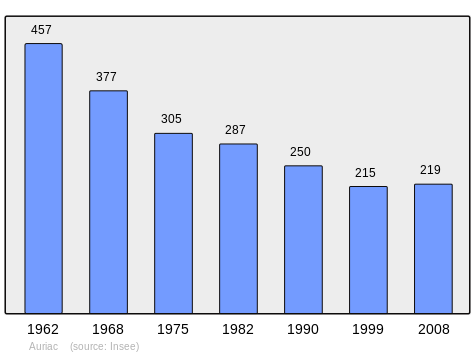
In 2010 the commune had 228 inhabitants. The evolution of the number of inhabitants is known from the population censuses conducted in the commune since 1793. From the 21st century, a census of communes with fewer than 10,000 inhabitants is held every five years, unlike larger towns that have a sample survey every year.[Note 1]
| 1793 | 1800 | 1806 | 1821 | 1831 | 1836 | 1841 | 1846 | 1851 |
|---|---|---|---|---|---|---|---|---|
| 1,290 | 967 | 1,127 | 1,145 | 1,277 | 1,353 | 1,302 | 1,333 | 1,385 |
| 1856 | 1861 | 1866 | 1872 | 1876 | 1881 | 1886 | 1891 | 1896 |
|---|---|---|---|---|---|---|---|---|
| 1,413 | 1,314 | 1,333 | 1,200 | 1,212 | 1,181 | 1,151 | 1,020 | 982 |
| 1901 | 1906 | 1911 | 1921 | 1926 | 1931 | 1936 | 1946 | 1954 |
|---|---|---|---|---|---|---|---|---|
| 908 | 935 | 900 | 815 | 752 | 689 | 708 | 612 | 518 |
| 1962 | 1968 | 1975 | 1982 | 1990 | 1999 | 2006 | 2010 | - |
|---|---|---|---|---|---|---|---|---|
| 457 | 377 | 305 | 287 | 250 | 215 | - | 228 | - |
Sources : Ldh/EHESS/Cassini until 1962, INSEE database from 1968 (population without double counting and municipal population from 2006)

Economy
Salers cattle are raised in the commune.
Local culture and heritage

Civil heritage
- Camping at the artificial lake
- Redenat Waterfall
- A Tumulus at Puy-de-Valette
- The Menhir of Selves
- A House near the remains of the Keep which was the home of the former Prior.
- Panoramic view at Puy-du-Bassin
- The Dordogne Valley.
- The Confluence of the Luzège.
Since 2013 there has been a Natural Heritage Interpretation path which leads to the top of the Xaintrie at Puy du Bassin from the town centre.[5]
Religious heritage

- The remains of the abbey of Valletta from the 12th century are submerged in the lake behind the Chastang Dam.
- The Chapel of Puy du Bassin (at an altitude of 707 m)
- A Church (15th-16th century)
- The Chapel Dézéjouls (19th century).
- The Chapel Notre-Dame-de-Chastres at Cours (19th century).
- A Monumental granite cross (19th century).
- A Wayside Cross (15th century).
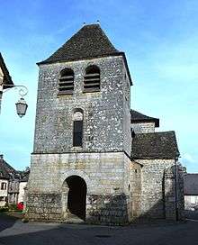
- The Church of Saint-Côme Saint-Damien (12th century),
 [6] which was the former priory, is registered as a historical monument. The church contains two items which are registered as historical objects:
Notable people linked to the commune
- Denis Tillinac [Why?], writer and friend of Jacques Chirac.
- Guy Bernard spent part of his life in Auriac in the 1980s.
See also
External links
- Auriac official website (French)
- Auriac on Lion1906
- Auriac on Google Maps
- Auriac on Géoportail, National Geographic Institute (IGN) website (French)
- Auriac on the 1750 Cassini Map
- Auriac on the INSEE website (French)
- INSEE (French)
Notes and references
Notes
- ↑ At the beginning of the 21st century, the methods of identification have been modified by Law No. 2002-276 of 27 February 2002, the so-called "law of local democracy" and in particular Title V "census operations" allows, after a transitional period running from 2004 to 2008, the annual publication of the legal population of the different French administrative districts. For communes with a population greater than 10,000 inhabitants, a sample survey is conducted annually, the entire territory of these communes is taken into account at the end of the period of five years. The first "legal population" after 1999 under this new law came into force on 1 January 2009 and was based on the census of 2006.
References
- ↑ Inhabitants of Corrèze (French)
- 1 2 3 Google Maps
- ↑ A Cistercian Abbey: Valette, Lomovica website
- ↑ List of Mayors of France (French)
- ↑ Natural Heritage Interpretation website (French)
- ↑ Ministry of Culture, Mérimée PA00099662 Church of Saint-Côme Saint-Damien (French)
- ↑ Ministry of Culture, Palissy PM19000028 Collection Plate: the Annunciation
(French)

- ↑ Ministry of Culture, Palissy PM19000027 Eucharistic Cross
(French)
| Wikimedia Commons has media related to Auriac (Corrèze). |