Apple Valley, Utah
| Apple Valley | |
|---|---|
| Town | |
|
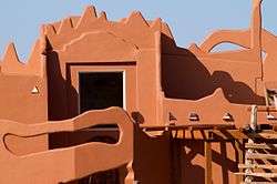
A house in Apple Valley | |
 Location in Washington County and the state of Utah | |
| Coordinates: 37°04′33″N 113°05′27″W / 37.07583°N 113.09083°WCoordinates: 37°04′33″N 113°05′27″W / 37.07583°N 113.09083°W | |
| Country | United States |
| State | Utah |
| County | Washington |
| Incorporated | October 15, 2004 |
| Government | |
| • Mayor | Rick Moser |
| Area[1] | |
| • Total | 40.7 sq mi (105 km2) |
| • Land | 40.7 sq mi (105 km2) |
| • Water | 0 sq mi (0 km2) |
| Elevation[2] | 4,961 ft (1,512 m) |
| Population (2010)[3] | |
| • Total | 701 |
| • Density | 17/sq mi (6.7/km2) |
| Time zone | Mountain (MST) (UTC-7) |
| • Summer (DST) | MDT (UTC-6) |
| ZIP code | 84737 |
| Area code(s) | 435 |
| GNIS feature ID | 2412373[2] |
Apple Valley is a town in Washington County, Utah, United States, located 12 miles (19 km) east of Hurricane along SR-59. The population was 701 at the 2010 census.
Apple Valley was incorporated on October 15, 2004, and a 2007 population estimate by the US Census Bureau placed its population at 427. In 2006, some residents of the town signed a petition calling for dis-incorporation, saying that its incorporation was premature. They obtained enough signatures to call for a vote of dis-incorporation,[4] but the attempt was unsuccessful. Another dis-incorporation vote on June 19, 2012 also failed.[5]
Demographics
| Historical population | |||
|---|---|---|---|
| Census | Pop. | %± | |
| 2010 | 701 | — | |
| Est. 2015 | 718 | [6] | 2.4% |
As of the census[3] of 2010, there were 701 people residing in the town. There were 295 housing units. The racial makeup of the town was 94.3% White, 3.0% American Indian and Alaska Native, 0.1% Asian, 1.3% from some other race, and 1.3% from two or more races. Hispanic or Latino of any race were 3.3% of the population.
References
- ↑ "2010 Census U.S. Gazetteer File for Places: Utah". Retrieved May 23, 2011.
- 1 2 "Apple Valley". Geographic Names Information System. United States Geological Survey. Retrieved May 26, 2011.
- 1 2 "American FactFinder". United States Census Bureau. Retrieved July 20, 2012.
- ↑ "Petition aims to pull plug on Apple Valley". Deseret News. August 1, 2006. Retrieved November 25, 2008.
- ↑ Foy, Paul (June 20, 2012). "Southern Utah's Apple Valley votes against dissolving government". Deseret News. Retrieved June 28, 2012.
- ↑ "Annual Estimates of the Resident Population for Incorporated Places: April 1, 2010 to July 1, 2015". Retrieved July 2, 2016.
- ↑ "Census of Population and Housing". Census.gov. Archived from the original on May 11, 2015. Retrieved June 4, 2015.
External links
 |
Virgin | Zion National Park | Rockville | |
| Hurricane | |
Lake Powell | ||
| ||||
| | ||||
| Grand Canyon National Park | Grand Canyon National Park | Hildale |
Municipalities and communities of Washington County, Utah, United States | ||
|---|---|---|
| Cities | 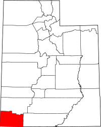 | |
| Towns | ||
| CDPs | ||
| Unincorporated communities | ||
| Ghost towns | ||