Enterprise, Utah
| Enterprise, Utah | |
|---|---|
| City | |
 Location in Washington County and the state of Utah | |
| Coordinates: 37°34′16″N 113°43′5″W / 37.57111°N 113.71806°WCoordinates: 37°34′16″N 113°43′5″W / 37.57111°N 113.71806°W | |
| Country | United States |
| State | Utah |
| County | Washington |
| Founded | 1891 |
| Founded by | Orson Huntsman |
| Area | |
| • Total | 2.9 sq mi (7.5 km2) |
| • Land | 2.9 sq mi (7.5 km2) |
| • Water | 0.0 sq mi (0.0 km2) |
| Elevation | 5,318 ft (1,621 m) |
| Population (2012) | |
| • Total | 1,752 |
| • Density | 441.0/sq mi (170.3/km2) |
| Time zone | Mountain (MST) (UTC-7) |
| • Summer (DST) | MDT (UTC-6) |
| ZIP code | 84725 |
| Area code(s) | 435 |
| FIPS code | 49-23420[1] |
| GNIS feature ID | 1440940[2] |
Enterprise is a city in Washington County, Utah, United States. The population was 1,711 at the 2010 census. Enterprise is home to two schools, Enterprise Elementary School (K-6) and Enterprise High School (7-12).
Geography
Enterprise is located on the south rim of the Great Basin, at an elevation of 5,329 feet (1,624 m).
According to the United States Census Bureau, the city has a total area of 2.9 square miles (7.5 km²), all of it land.
Enterprise is the nearest community to Mountain Meadows. The November 17, 1902 Pine Valley earthquake, estimated to be a 6 on the Richter magnitude scale, had its epicenter about 20 miles (32 km) southeast of the town.
Climate
According to the Köppen Climate Classification system, Enterprise has a semi-arid climate, abbreviated "BSk" on climate maps.[3]
History
A post office called Enterprise has been in operation since 1899.[4] The town was so named for the settlers' enterprising plan to find a water supply.[5]
Demographics
| Historical population | |||
|---|---|---|---|
| Census | Pop. | %± | |
| 1890 | 41 | — | |
| 1900 | 100 | 143.9% | |
| 1910 | 350 | 250.0% | |
| 1920 | 608 | 73.7% | |
| 1930 | 548 | −9.9% | |
| 1940 | 677 | 23.5% | |
| 1950 | 790 | 16.7% | |
| 1960 | 859 | 8.7% | |
| 1970 | 844 | −1.7% | |
| 1980 | 905 | 7.2% | |
| 1990 | 936 | 3.4% | |
| 2000 | 1,285 | 37.3% | |
| 2010 | 1,711 | 33.2% | |
| Est. 2015 | 1,799 | [6] | 5.1% |
As of the census[1] of 2000, there were 1,285 people, 378 households, and 317 families residing in the town. The population density was 441.0 people per square mile (170.5/km²). There were 454 housing units at an average density of 155.8 per square mile (60.2/km²). The racial makeup of the town was 95.25% White, 2.49% Native American, 0.23% Asian, 0.78% from other races, and 1.25% from two or more races. Hispanic or Latino of any race were 1.17% of the population.
There were 378 households out of which 49.5% had children under the age of 18 living with them, 73.8% were married couples living together, 7.4% had a female householder with no husband present, and 16.1% were non-families. 15.1% of all households were made up of individuals and 9.3% had someone living alone who was 65 years of age or older. The average household size was 3.40 and the average family size was 3.82.
In the town the population was spread out with 40.0% under the age of 18, 8.9% from 18 to 24, 21.3% from 25 to 44, 18.0% from 45 to 64, and 11.8% who were 65 years of age or older. The median age was 26 years. For every 100 females there were 100.8 males. For every 100 females age 18 and over, there were 101.8 males.
The median income for a household in the town was $35,694, and the median income for a family was $38,500. Males had a median income of $31,905 versus $16,354 for females. The per capita income for the town was $13,858. About 4.3% of families and 6.1% of the population were below the poverty line, including 4.8% of those under age 18 and 5.0% of those age 65 or over.
Government
Mayor S. Lee Bracken
City Council Jared Bollinger, Darcy Holt, Barry Jones, Jared Holt, Shalyn Nelson
City Manager Adam Bowler
References
- 1 2 "American FactFinder". United States Census Bureau. Retrieved 2008-01-31.
- ↑ "US Board on Geographic Names". United States Geological Survey. 2007-10-25. Retrieved 2008-01-31.
- ↑ Climate Summary for Enterprise, Utah
- ↑ "Washington County". Jim Forte Postal History. Retrieved 18 October 2015.
- ↑ Van Atta, Dale (Jan 22, 1977). "You name it - there's a town for it". The Deseret News. p. 15. Retrieved 18 October 2015.
- ↑ "Annual Estimates of the Resident Population for Incorporated Places: April 1, 2010 to July 1, 2015". Retrieved July 2, 2016.
- ↑ "Census of Population and Housing". Census.gov. Retrieved June 4, 2015.
External links
 |
|
|
Milford Minersville |
|
| |
|
Enoch Cedar City Kanarraville New Harmony | ||
| ||||
| | ||||
| |
Ivins, St. George | Washington, Hurricane, Leeds, Toquerville |
Municipalities and communities of Washington County, Utah, United States | ||
|---|---|---|
| Cities | 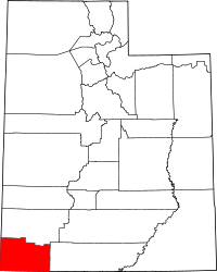 | |
| Towns | ||
| CDPs | ||
| Unincorporated communities | ||
| Ghost towns | ||