Virgin, Utah
| Virgin, Utah | |
|---|---|
|
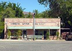
Virgin Bookshop and Post Office | |
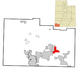 Location in Washington County and the state of Utah | |
| Coordinates: 37°12′6″N 113°11′23″W / 37.20167°N 113.18972°WCoordinates: 37°12′6″N 113°11′23″W / 37.20167°N 113.18972°W | |
| Country | United States |
| State | Utah |
| County | Washington |
| Settled | 1857 |
| Named for | Virgin River |
| Area | |
| • Total | 11.9 sq mi (30.9 km2) |
| • Land | 11.9 sq mi (30.9 km2) |
| • Water | 0.0 sq mi (0.0 km2) |
| Elevation | 3,606 ft (1,099 m) |
| Population (2012) | |
| • Total | 606 |
| • Density | 50.1/sq mi (19.3/km2) |
| Time zone | Mountain (MST) (UTC-7) |
| • Summer (DST) | MDT (UTC-6) |
| ZIP code | 84779 |
| Area code(s) | 435 |
| FIPS code | 49-80530[1] |
| GNIS feature ID | 1433898[2] |
Virgin is a town in Washington County, Utah, United States. The population was 596 at the 2010 census. It is located along the Virgin River (for which it is named), not far from Zion National Park. The elevation is 3,606 feet (1,099 m). It lies on the route of State Route 9.
Geography
According to the United States Census Bureau, the town has a total area of 11.9 square miles (30.9 km²), all of it land.
Demographics
| Historical population | |||
|---|---|---|---|
| Census | Pop. | %± | |
| 1860 | 79 | — | |
| 1870 | 224 | 183.5% | |
| 1880 | 254 | 13.4% | |
| 1890 | 213 | −16.1% | |
| 1900 | 269 | 26.3% | |
| 1910 | 136 | −49.4% | |
| 1920 | 212 | 55.9% | |
| 1930 | 202 | −4.7% | |
| 1940 | 143 | −29.2% | |
| 1950 | 147 | 2.8% | |
| 1960 | 124 | −15.6% | |
| 1970 | 119 | −4.0% | |
| 1980 | 169 | 42.0% | |
| 1990 | 229 | 35.5% | |
| 2000 | 394 | 72.1% | |
| 2010 | 596 | 51.3% | |
| Est. 2015 | 604 | [3] | 1.3% |
As of the census[1] of 2010, there were 596 people, 202 households, and 139 families residing in the town. The population density was 50.1 people per square mile (19.3/km²). There were 243 housing units at an average density of 20.4 per square mile (7.9/km²). The racial makeup of the town was 91.8% White, 2.2% Native American, 0.5% Asian, 0.2% Pacific Islander, and 2.0% from two or more races. Hispanic or Latino of any race were 6.4% of the population.
There were 202 households out of which 23.8% had children under the age of 18 living with them, 57.9% were married couples living together, 6.9% had a female householder with no husband present, and 31.2% were non-families. 22.3% of all households were made up of individuals and 9.9% had someone living alone who was 65 years of age or older. The average household size was 2.64 and the average family size was 3.14.
In the town the population was spread out with 36.8% under the age of 24, 23.5% from 25 to 44, 26.1% from 45 to 64, and 13.6% who were 65 years of age or older. The median age was 35.6 years. For every 100 females there were 116.7 males. For every 100 females age 18 and over, there were 100.4 males.
The median income for a household in the town was $55,625, and the median income for a family was $50,250. Males had a median income of $40,167 versus $19,783 for females. The per capita income for the town was $19,408. About 8.0% of families and 7.4% of the population were below the poverty line, including 6.4% of those under age 18 and 8.0% of those age 65 or over.
Mandatory gun ownership
In May 2000, a law was passed which required every homeowner to keep and maintain a firearm. This was highlighted in Michael Moore's 2002 film Bowling for Columbine. Exceptions to this law include "the mentally ill, convicted felons, conscientious objectors and people who cannot afford to own a gun".
References
- 1 2 "American FactFinder". United States Census Bureau. Retrieved 2011-05-14.
- ↑ "US Board on Geographic Names". United States Geological Survey. 2007-10-25. Retrieved 2008-01-31.
- ↑ "Annual Estimates of the Resident Population for Incorporated Places: April 1, 2010 to July 1, 2015". Retrieved July 2, 2016.
- ↑ "Census of Population and Housing". Census.gov. Retrieved June 4, 2015.
External links
| Wikimedia Commons has media related to Virgin, Utah. |
 |
New Harmony | Kanarraville | Zion National Park | |
| La Verkin | |
Springdale | ||
| ||||
| | ||||
| Hurricane | Apple Valley | Rockville |
Municipalities and communities of Washington County, Utah, United States | ||
|---|---|---|
| Cities | 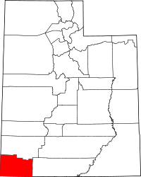 | |
| Towns | ||
| CDPs | ||
| Unincorporated communities | ||
| Ghost towns | ||