Alca District
| Alca | |
|---|---|
| District | |
|
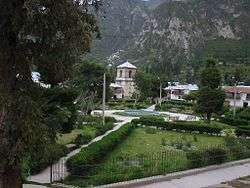
Main square of Alca | |
| Country |
|
| Region | Arequipa |
| Province | La Unión |
| Founded | May 4, 1835 |
| Capital | Alca |
| Government | |
| • Mayor | Benjamin Barrios Bellido |
| Area | |
| • Total | 193.42 km2 (74.68 sq mi) |
| Elevation | 2,750 m (9,020 ft) |
| Population (2005 census) | |
| • Total | 2,263 |
| • Density | 12/km2 (30/sq mi) |
| Time zone | PET (UTC-5) |
| UBIGEO | 040802 |
Alca District is one of eleven districts of the province La Unión in Peru.[1]
Ethnic groups
The people in the district are mainly indigenous citizens of Quechua descent. Quechua is the language which the majority of the population (78.33%) learnt to speak in childhood, 20.69% of the residents started speaking using the Spanish language (2007 Peru Census).[2]
See also
References
- ↑ (Spanish) Instituto Nacional de Estadística e Informática. Banco de Información Distrital Archived April 23, 2008, at the Wayback Machine.. Retrieved April 11, 2008.
- ↑ inei.gob.pe INEI, Peru, Censos Nacionales 2007, Frequencias: Preguntas de Población: Idioma o lengua con el que aprendió hablar (in Spanish)
Coordinates: 15°08′50″S 72°46′52″W / 15.1471°S 72.7811°W
This article is issued from Wikipedia - version of the 11/14/2016. The text is available under the Creative Commons Attribution/Share Alike but additional terms may apply for the media files.