Albrechtice (Karviná District)
| Albrechtice Olbrachcice | |||
|---|---|---|---|
| Village | |||
|
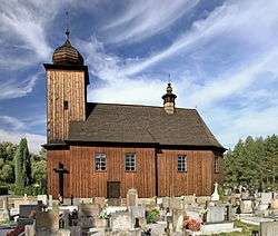
Saint Peter and Saint Paul Church | |||
| |||
 Location in the Czech Republic | |||
| Coordinates: 49°46′59″N 18°31′19″E / 49.78306°N 18.52194°E | |||
| Country | Czech Republic | ||
| Region | Moravian-Silesian | ||
| District | Karviná | ||
| First mentioned | 1447 | ||
| Government | |||
| • Mayor | Vladislav Šipula | ||
| Area | |||
| • Total | 12.68 km2 (4.90 sq mi) | ||
| Elevation | 258 m (846 ft) | ||
| Population (2006) | |||
| • Total | 3,974 | ||
| • Density | 310/km2 (810/sq mi) | ||
| Postal code | 735 43 | ||
| Website | http://www.obecalbrechtice.cz/ | ||

Albrechtice (![]() listen , Polish: Olbrachcice , German: Albersdorf) is a large village in Karviná District, Moravian-Silesian Region of the Czech Republic. It is located 8 km south of Karviná, on the Stonávka River and has a population of 4,071 (2001 census). 23.5% of the population are Poles.[1] It lies in the historical region of Cieszyn Silesia.
listen , Polish: Olbrachcice , German: Albersdorf) is a large village in Karviná District, Moravian-Silesian Region of the Czech Republic. It is located 8 km south of Karviná, on the Stonávka River and has a population of 4,071 (2001 census). 23.5% of the population are Poles.[1] It lies in the historical region of Cieszyn Silesia.
The name of the village is patronymic in origin, derived from the personal name Olbracht (≤ German Albrecht), at first ending with German -dorf meaning village, and later also ending with typically Slavic -ice.[2]
History
The village was first mentioned in the register of Peter's Pence payment from 1447 among the 50 parishes of Teschen deanery as Albrothsdorff.[3] Politically the village belonged to the Duchy of Teschen, which was since 1327 a fee of the Kingdom of Bohemia, which after 1526 became part of the Habsburg Monarchy.
After the 1540s Protestant Reformation prevailed in the Duchy of Teschen and a local Catholic church was taken over by Lutherans. It was taken from them (as one from around fifty buildings in the region) by a special commission and given back to the Roman Catholic Church on 26 March 1654.[4]
After the Revolutions of 1848 in the Austrian Empire, a modern municipal division was introduced in the re-established Austrian Silesia. The village as a municipality was subscribed at least since 1880 to political district and legal district of Freistadt.
According to the censuses conducted in 1880, 1890, 1900 and 1910 the population of the municipality grew from 1,070 in 1880 to 1,335 in 1910. In 1880 96.9% of inhabitants declared being Czech-speaking, followed by 33 or 3.1% German-speakers. In the next censuses majority were Polish-speaking (growing from 97.9% in 1890 to 99.5% in 1910), followed by diminishing number of German-speakers (from 23 or 2.1% in 1890 to 6 or 0.5% in 1910). In terms of religion, in 1910 the majority were Roman Catholics (899 or 67.3%), followed by Protestants (424 or 31.8%) and Jews (11 or 0.8%).[5] The village was also traditionally inhabited by Silesian Lachs, speaking Cieszyn Silesian dialect.
After World War I, the fall of Austria-Hungary, the Polish–Czechoslovak War and the division of Cieszyn Silesia in 1920, the village became a part of Czechoslovakia. Following the Munich Agreement, in October 1938 together with the Zaolzie region it was annexed by Poland, administratively organised in Frysztat County of Silesian Voivodeship.[6] The village was then annexed by Nazi Germany at the beginning of World War II. After the war it was restored to Czechoslovakia.
Footnotes
- ↑ "2001 census data". Czech Statistical Office.
- ↑ Mrózek, Robert (1984). Nazwy miejscowe dawnego Śląska Cieszyńskiego [Local names of former Cieszyn Silesia] (in Polish). Katowice: Uniwersytet Śląski w Katowicach. pp. 130–131, 246. ISSN 0208-6336.
- ↑ "Registrum denarii sancti Petri in archidiaconatu Opoliensi sub anno domini MCCCCXLVII per dominum Nicolaum Wolff decretorum doctorem, archidiaconum Opoliensem, ex commissione reverendi in Christo patris ac domini Conradi episcopi Wratislaviensis, sedis apostolice collectoris, collecti". Zeitschrift des Vereins für Geschichte und Alterthum Schlesiens (in German). Breslau: H. Markgraf. 27: 361–372. 1893. Retrieved 21 July 2014.
- ↑ Broda, Jan (1992). "Materiały do dziejów Kościoła ewangelickiego w Księstwie Cieszyńskim i Państwie Pszczyńskim w XVI i XVII wieku". Z historii Kościoła ewangelickiego na Śląsku Cieszyńskim (in Polish). Katowice: Dom Wydawniczy i Księgarski „Didache“. pp. 259–260. ISBN 83-85572-00-7.
- ↑ Piątkowski, Kazimierz (1918). Stosunki narodowościowe w Księstwie Cieszyńskiem (in Polish). Cieszyn: Macierz Szkolna Księstwa Cieszyńskiego. pp. 273, 290.
- ↑ "Ustawa z dnia 27 października 1938 r. o podziale administracyjnym i tymczasowej organizacji administracji na obszarze Ziem Odzyskanych Śląska Cieszyńskiego". Dziennik Ustaw Śląskich (in Polish). Katowice. nr 18/1938, poz. 35. 31 October 1938. Retrieved 1 July 2014.
References
- Londzin, Józef (1932). Kościoły drewniane na Śląsku Cieszyńskim. Cieszyn: Dziedzictwo błog. Jana Sarkandra. pp. 227–237. OCLC 297540848.
External links
- (Czech) Official website
| Wikimedia Commons has media related to Albrechtice. |

Coordinates: 49°46′59″N 18°31′19″E / 49.78306°N 18.52194°E