Dolní Lomná
| Dolní Lomná Łomna Dolna | |||
|---|---|---|---|
| Village | |||
|
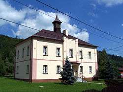
Polish elementary school | |||
| |||
 Location in the Czech Republic | |||
| Coordinates: 49°32′35″N 18°42′22″E / 49.54306°N 18.70611°ECoordinates: 49°32′35″N 18°42′22″E / 49.54306°N 18.70611°E | |||
| Country | Czech Republic | ||
| Region | Moravian-Silesian | ||
| District | Frýdek-Místek | ||
| First mentioned | 1684 | ||
| Government | |||
| • Mayor | Renata Pavlinová | ||
| Area | |||
| • Total | 27.03 km2 (10.44 sq mi) | ||
| Elevation | 460 m (1,510 ft) | ||
| Population (2006) | |||
| • Total | 871 | ||
| • Density | 32/km2 (83/sq mi) | ||
| Postal code | 739 82 | ||
| Website |
www | ||
![]() Dolní Lomná (Polish: Łomna Dolna , Cieszyn Silesian: Dolno Łómna or Dolno Łómno , German: Nieder Lomna) is a village in Moravian-Silesian Region, Czech Republic, close to the borders with Poland and Slovakia. It has a population of 867 (2001 census), 31% of the population are the Poles and 72% are Roman Catholics.[1] It is situated in the Moravian-Silesian Beskids mountain range, in the historical region of Cieszyn Silesia. Lomná River flows through the village.
Dolní Lomná (Polish: Łomna Dolna , Cieszyn Silesian: Dolno Łómna or Dolno Łómno , German: Nieder Lomna) is a village in Moravian-Silesian Region, Czech Republic, close to the borders with Poland and Slovakia. It has a population of 867 (2001 census), 31% of the population are the Poles and 72% are Roman Catholics.[1] It is situated in the Moravian-Silesian Beskids mountain range, in the historical region of Cieszyn Silesia. Lomná River flows through the village.
The name of the village is of topographic origin borrowed from an older name of the Lomna river (mentioned in 1592 as Lomny), which itself is derived from the words łom (clatter, rumble, susurrus) or załom (turn, bend).[2]
History
The settlement on the territory of the village in the Lomna river valley in Moravian-Silesian Beskids began in the middle of the 17th century. The village was first mentioned in 1684 as Lomna.[2][3] It belonged then to the Duchy of Teschen, a fee of the Kingdom of Bohemia and a part of the Habsburg Monarchy.
After Revolutions of 1848 in the Austrian Empire a modern municipal division was introduced in the re-established Austrian Silesia. Lomna as a single municipality was subscribed to the political district of Cieszyn and the legal district of Jablunkov. In 1873 two separate settlements (German: Ortshaften) were recognised: Dolní Lomná (as Dolny Lomna) and Horní Lomná as (Wrchny Lomna). They were divided into two separate municipalities on 1 January 1890. According to the censuses conducted in 1890, 1900 and 1910 the population of the municipality grew from 857 in 1890 to 912 in 1910. In 1910 the majority of the inhabitants were native Polish-speakers (95.1%) accompanied by a German-speaking minority (32 or 3.5%) and Czech-speaking people (13 or 1.4%). In terms of religion in 1910 the majority were Roman Catholics (82.5%), followed by Protestants (17.3%) and Jews (2 people).[4] The village was also traditionally inhabited by Silesian Gorals, speaking Jablunkov dialect.
After World War I, fall of Austria-Hungary, Polish–Czechoslovak War and the division of Cieszyn Silesia in 1920, it became a part of Czechoslovakia. Following the Munich Agreement, in October 1938 together with the Zaolzie region it was annexed by Poland, administratively adjoined to Cieszyn County of Silesian Voivodeship.[5] It was then annexed by Nazi Germany at the beginning of World War II. After the war it was restored to Czechoslovakia.
From 1975 to 1990 the village was administratively a part of Jablunkov.
 Wooden house
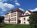 Czech elementary school
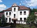 Municipal office and post office
 Monument dedicated to local victims of World War I.
References
- ↑ "2001 census data". Czech Statistical Office.
- 1 2 Mrózek, Robert (1984). Nazwy miejscowe dawnego Śląska Cieszyńskiego [Local names of former Cieszyn Silesia] (in Polish). Katowice: Uniwersytet Śląski w Katowicach. p. 97. ISSN 0208-6336.
- ↑ Panic, Idzi (2011). Śląsk Cieszyński w początkach czasów nowożytnych (1528-1653) [Cieszyn Silesia in the beginnings of Modern Era (1528-1653)] (in Polish). Cieszyn: Starostwo Powiatowe w Cieszynie. p. 111. ISBN 978-83-926929-5-9.
- ↑ Piątkowski, Kazimierz (1918). Stosunki narodowościowe w Księstwie Cieszyńskiem (in Polish). Cieszyn: Macierz Szkolna Księstwa Cieszyńskiego. pp. 266, 285.
- ↑ "Ustawa z dnia 27 października 1938 r. o podziale administracyjnym i tymczasowej organizacji administracji na obszarze Ziem Odzyskanych Śląska Cieszyńskiego". Dziennik Ustaw Śląskich (in Polish). Katowice. nr 18/1938, poz. 35. 31 October 1938. Retrieved 1 July 2014.
External links
| Wikimedia Commons has media related to Dolní Lomná. |
- (Czech) Official website