Dětmarovice
| Dětmarovice | |||
|---|---|---|---|
| Village | |||
|
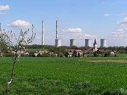
View on Dětmarovice | |||
| |||
 Location in the Czech Republic | |||
| Coordinates: 49°53′12″N 18°27′44″E / 49.88667°N 18.46222°E | |||
| Country | Czech Republic | ||
| Region | Moravian-Silesian | ||
| District | Karviná | ||
| First mentioned | 1305 | ||
| Government | |||
| • Mayor | Ladislav Rosman | ||
| Area | |||
| • Total | 13.76 km2 (5.31 sq mi) | ||
| Elevation | 214 m (702 ft) | ||
| Population (2012) | |||
| • Total | 4,079 | ||
| • Density | 300/km2 (770/sq mi) | ||
| Postal code | 735 71 | ||
| Website | http://www.detmarovice.cz/ | ||
![]() Dětmarovice (Polish: Dziećmorowice , German: Dittmarsdorf) (also Dittmannsdorf) is a village in the Karviná District, Moravian-Silesian Region, Czech Republic, on the Olza River. It lies near the border with Poland, in the historical region of Cieszyn Silesia. Near the right bank of the Olza lies a complex of 15 ponds.
Dětmarovice (Polish: Dziećmorowice , German: Dittmarsdorf) (also Dittmannsdorf) is a village in the Karviná District, Moravian-Silesian Region, Czech Republic, on the Olza River. It lies near the border with Poland, in the historical region of Cieszyn Silesia. Near the right bank of the Olza lies a complex of 15 ponds.
The name is patronymic in origin derived from German personal name Dietmar. First mentioned (ca. 1305) in Latin form Dithmari villa, later as Dytmarsdorff (1392), Dietmarsdorf (1430), Dieczmarowicz[e] (1438, 1447), Dieczmiorowice (1652), Dittmersdorf P. Dieczmorowitz (1736), Dittmansdorf, pohlnisch Dietmarowicze (1804), Dittmannsdorf, Dětmarovice, Dziećmarowice (1900).[1]
History
The village was first mentioned in a Latin document of Diocese of Wrocław called Liber fundationis episcopatus Vratislaviensis from around 1305 as item in Dithmari villa sunt triginta octo mansi.[2][3][4][5] It meant that the village had 38 smaller lans. The creation of the village was a part of a larger settlement campaign taking place in the late 13th century on the territory of what will be later known as Upper Silesia.
The village became a seat of a Catholic parish, mentioned in the register of Peter's Pence payment from 1447 among 50 parishes of Teschen deanery as Ditmari villa.[6]
Politically the village belonged initially to the Duchy of Teschen, formed in 1290 in the process of feudal fragmentation of Poland and was ruled by a local branch of Piast dynasty. In 1327 the duchy became a fee of Kingdom of Bohemia, which after 1526 became part of the Habsburg Monarchy. In 1573 it was sold as one of a dozen villages and the town of Freistadt and formed a state country split from the Duchy of Teschen.[7]
The village was bought in 1792 by Jan Larisch who joined it with its Karwin properties. It was owned by the Larisch family until 1927.
After Revolutions of 1848 in the Austrian Empire a modern municipal division was introduced in the re-established Austrian Silesia. The village as a municipality was subscribed in 1869 to the newly established Freistadt political district and Oderberg legal district, but before 1890 the municipality was transferred to Freistadt legal district. A formerly separate village of Koukolná became administratively a part of Dětmarovice in 1872-1875.
According to the censuses conducted in 1880, 1890, 1900 and 1910 the population of the municipality grew from 1,769 in 1880 to 3,453 in 1910. In three censuses majority were Czech-speakers (84.9% in 1880, 64% in 1890, 77.1% in 1910, 12.5% minority in 1900), in 1900 majority were Polish-speakers (86.7%, in other censuses minority: 13.9% in 1880, 34.6% in 1890, 21.8% in 1910). They were accompanied by German-speaking minority (between 0.8% and 1.4%). In terms of religion in 1910 the majority were Roman Catholics (98.2%), followed by Jews (31 or 0.9%), Protestants (19 or 0.6%) and others (15 or 0.3%).[8]
The DITTMANNSDORF post-office (in Austrian Silesia) was opened in 1895.[9]
After World War I, fall of Austria-Hungary, Polish–Czechoslovak War and the division of Cieszyn Silesia in 1920, the village became a part of Czechoslovakia. Following the Munich Agreement, in October 1938 together with the Zaolzie region it was annexed by Poland, administratively organised in Frysztat County of Silesian Voivodeship.[10] The village was then annexed by Nazi Germany at the beginning of World War II. After the war it was restored to Czechoslovakia.
Historical landmarks include the Nebroj chapel from around 1860 and a Catholic Mary Magdalene Church built in 1869-1870 in Neo-Romanesque style.
There is a large thermal power station in the village. It was built in 1971-1976. It is the only large thermal power station in the country burning black coal. In 1998 a filter reducing the air pollution was installed. The power station is situated on an important main railway line from Prague/Vienna to Warsaw. Another important line to Český Těšín - Žilina - Košice splits here from the line to Warsaw.
Sport
Cycling
The city hosted the start of the first stage of the 2012 and 2013 Gracia-Orlová.
See also
Footnotes
- ↑ Mrózek, Robert (1984). Nazwy miejscowe dawnego Śląska Cieszyńskiego [Local names of former Cieszyn Silesia] (in Polish). Katowice: Uniwersytet Śląski w Katowicach. p. 63. ISSN 0208-6336.
- ↑ Hosák et al. 1980, 405.
- ↑ Panic, Idzi (2010). Śląsk Cieszyński w średniowieczu (do 1528) [Cieszyn Silesia in the Middle Ages (until 1528)] (in Polish). Cieszyn: Starostwo Powiatowe w Cieszynie. pp. 297–299. ISBN 978-83-926929-3-5.
- ↑ Schulte, Wilhelm (1889). Codex Diplomaticus Silesiae T.14 Liber Fundationis Episcopatus Vratislaviensis (in German). Breslau.
- ↑ "Liber fundationis episcopatus Vratislaviensis" (in Latin). Retrieved 13 July 2014.
- ↑ "Registrum denarii sancti Petri in archidiaconatu Opoliensi sub anno domini MCCCCXLVII per dominum Nicolaum Wolff decretorum doctorem, archidiaconum Opoliensem, ex commissione reverendi in Christo patris ac domini Conradi episcopi Wratislaviensis, sedis apostolice collectoris, collecti". Zeitschrift des Vereins für Geschichte und Alterthum Schlesiens (in German). Breslau: H. Markgraf. 27: 361–372. 1893. Retrieved 21 July 2014.
- ↑ Panic, Idzi (2011). Śląsk Cieszyński w początkach czasów nowożytnych (1528-1653) [Cieszyn Silesia in the beginnings of Modern Era (1528-1653)] (in Polish). Cieszyn: Starostwo Powiatowe w Cieszynie. pp. 226–227. ISBN 978-83-926929-5-9.
- ↑ Piątkowski, Kazimierz (1918). Stosunki narodowościowe w Księstwie Cieszyńskiem (in Polish). Cieszyn: Macierz Szkolna Księstwa Cieszyńskiego. pp. 273, 290.
- ↑ Die postalischen Abstempelungen auf den österreichischen Postwertzeichen-Ausgaben 1867, 1883 und 1890, Wilhelm KLEIN, 1967
- ↑ "Ustawa z dnia 27 października 1938 r. o podziale administracyjnym i tymczasowej organizacji administracji na obszarze Ziem Odzyskanych Śląska Cieszyńskiego". Dziennik Ustaw Śląskich (in Polish). Katowice. nr 18/1938, poz. 35. 31 October 1938. Retrieved 1 July 2014.
References
- Cicha, Irena; Jaworski, Kazimierz; Ondraszek, Bronisław; Stalmach, Barbara; Stalmach, Jan (2000). Olza od pramene po ujście. Český Těšín: Region Silesia. ISBN 80-238-6081-X.
External links
- (Czech) Official website
- (Czech) Unofficial website
| Wikimedia Commons has media related to Dětmarovice. |

Coordinates: 49°53′12″N 18°27′44″E / 49.88667°N 18.46222°E