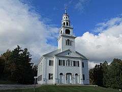
Acworth, New Hampshire
| Acworth, New Hampshire | |
|---|---|
| Town | |
 Location in Sullivan County and the state of New Hampshire. | |
| Coordinates: 43°13′04″N 72°17′31″W / 43.21778°N 72.29194°WCoordinates: 43°13′04″N 72°17′31″W / 43.21778°N 72.29194°W | |
| Country | United States |
| State | New Hampshire |
| County | Sullivan |
| Incorporated | 1772 |
| Government | |
| • Board of Selectmen |
David Goodwin, Chair Frank Emig Steven Holt |
| Area | |
| • Total | 39.1 sq mi (101.3 km2) |
| • Land | 38.9 sq mi (100.7 km2) |
| • Water | 0.2 sq mi (0.6 km2) 0.61% |
| Elevation | 1,489 ft (454 m) |
| Population (2010) | |
| • Total | 891 |
| • Density | 23/sq mi (8.8/km2) |
| Time zone | Eastern (UTC-5) |
| • Summer (DST) | Eastern (UTC-4) |
| ZIP code | 03601 |
| Area code(s) | 603 |
| FIPS code | 33-00260 |
| GNIS feature ID | 0873525 |
| Website |
homepages |
Acworth is a town in Sullivan County, New Hampshire, United States. At the 2010 census, the town had a total population of 891.[1]
History
Originally chartered by Governor Benning Wentworth in 1752, it was called Burnet after William Burnet, a former governor of the Province of Massachusetts Bay. In 1754, however, the French and Indian War broke out, and no settlements were made under the charter.[2] Wentworth regranted the township on 19 September 1766,[3] naming it after Sir Jacob Acworth, a former Surveyor of the Royal Navy. The town was first permanently settled in 1768 by several families from Londonderry.
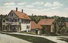
Acworth was incorporated in 1772 by Governor John Wentworth,[4] but war again slowed its development. With the close of the Revolution, however, Acworth grew quickly. By 1859, it had 1,251 inhabitants, most of whom were occupied in agriculture. The Cold River provided water power for industry, including 5 sawmills, a gristmill, a woolen factory, a bobbin factory and a peg factory. There was also a boot and shoe manufacturer.[2] Acworth is a source for museum-quality crystals such as beryl. The town of Acworth, Georgia was named for this town, because this was the hometown of a railroad engineer there.
Geography
According to the United States Census Bureau, the town has a total area of 39.1 square miles (101 km2), of which 38.9 sq mi (101 km2) is land and 0.2 sq mi (0.52 km2) is water, comprising 0.61% of the town. Acworth is drained by the Cold River, and lies fully within the Connecticut River watershed.[5] The highest point in Acworth is Gove Hill, at 1,939 feet (591 m) above sea level.
The town is crossed by one numbered state highway, New Hampshire Route 123A, which follows the Cold River and passes through the village of South Acworth.
Demographics
| Historical population | |||
|---|---|---|---|
| Census | Pop. | %± | |
| 1790 | 704 | — | |
| 1800 | 1,376 | 95.5% | |
| 1810 | 1,523 | 10.7% | |
| 1820 | 1,479 | −2.9% | |
| 1830 | 1,401 | −5.3% | |
| 1840 | 1,450 | 3.5% | |
| 1850 | 1,251 | −13.7% | |
| 1860 | 1,180 | −5.7% | |
| 1870 | 1,050 | −11.0% | |
| 1880 | 982 | −6.5% | |
| 1890 | 717 | −27.0% | |
| 1900 | 594 | −17.2% | |
| 1910 | 536 | −9.8% | |
| 1920 | 436 | −18.7% | |
| 1930 | 471 | 8.0% | |
| 1940 | 477 | 1.3% | |
| 1950 | 418 | −12.4% | |
| 1960 | 371 | −11.2% | |
| 1970 | 459 | 23.7% | |
| 1980 | 590 | 28.5% | |
| 1990 | 776 | 31.5% | |
| 2000 | 836 | 7.7% | |
| 2010 | 891 | 6.6% | |
| Est. 2015 | 887 | [6] | −0.4% |
As of the census[8] of 2000, there were 836 people, 318 households, and 234 families residing in the town. The population density was 21.5 people per square mile (8.3/km²). There were 512 housing units at an average density of 13.2 per square mile (5.1/km²). The racial makeup of the town was 96.77% White, 0.84% African American, 0.84% Native American, 0.24% Asian, and 1.32% from two or more races. Hispanic or Latino of any race were 1.08% of the population.
There were 318 households out of which 30.8% had children under the age of 18 living with them, 60.7% were married couples living together, 6.0% had a female householder with no husband present, and 26.4% were non-families. 19.8% of all households were made up of individuals and 7.5% had someone living alone who was 65 years of age or older. The average household size was 2.63 and the average family size was 3.06.
In the town the population was spread out with 25.7% under the age of 18, 4.7% from 18 to 24, 24.0% from 25 to 44, 30.4% from 45 to 64, and 15.2% who were 65 years of age or older. The median age was 43 years. For every 100 females there were 101.4 males. For every 100 females age 18 and over, there were 101.0 males.
The median income for a household in the town was $37,386, and the median income for a family was $41,397. Males had a median income of $29,792 versus $26,912 for females. The per capita income for the town was $18,132. About 10.1% of families and 15.6% of the population were below the poverty line, including 26.6% of those under age 18 and 5.4% of those age 65 or over.
Notable people
- Nedom L. Angier, mayor of Atlanta and Georgia state treasurer
- Thomas J. Cram, engineer in the service of the U.S. Corps of Topographical Engineers during the American Civil War
- Alice B. Fogel, New Hampshire Poet Laureate
- Talcott Parsons, Harvard sociologist
- Joseph Gardner Wilson, Oregon supreme court justice and US congressman
- Urban A. Woodbury, Civil War veteran and the 45th governor of Vermont
References
- ↑ United States Census Bureau, American FactFinder, 2010 Census figures. Retrieved March 23, 2011.
- 1 2 A. J. Coolidge & J. B. Mansfield, A History and Description of New England; Boston, Massachusetts 1859
- ↑ http://gedcomindex.com/Reference/New_Hampshire_1875/047.html Statistics and Gazetteer of New-Hampshire (1875)
- ↑ "New Hampshire Employment Security Community Profile: Acworth". Retrieved 2006-08-29.
- ↑ Foster, Debra H.; Batorfalvy, Tatianna N.; Medalie, Laura (1995). Water Use in New Hampshire: An Activities Guide for Teachers. U.S. Department of the Interior and U.S. Geological Survey.
- ↑ "Annual Estimates of the Resident Population for Incorporated Places: April 1, 2010 to July 1, 2015". Retrieved July 2, 2016.
- ↑ "Census of Population and Housing". Census.gov. Archived from the original on May 11, 2015. Retrieved June 4, 2016.
- ↑ "American FactFinder". United States Census Bureau. Archived from the original on 2013-09-11. Retrieved 2008-01-31.
Further reading
- John Leverett Merrill, History of Acworth, Acworth, New Hampshire 1869
- Helen H. Frink, These Acworth Hills - A History of Acworth, New Hampshire 1767 - 1988, Town of Acworth, New Hampshire 1989
External links
- Town of Acworth official website
- Acworth Historical Society
- Acworth Silsby Library
- The Acworthian, online newsletter
- New Hampshire Economic and Labor Market Information Bureau profile
- Hayward’s New England Gazetteer (1839)
Municipalities and communities of Sullivan County, New Hampshire, United States | ||
|---|---|---|
| City | 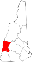 | |
| Towns | ||
| CDPs | ||
| Other villages | ||