A350 road
| |
|---|---|
|
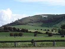
The A350 near Hindon, Wiltshire; the overbridge carries the A303 road | |
| Route information | |
| Length: | 70.1 mi[1] (112.8 km) |
| Major junctions | |
| north end: |
[[Image:Motorway Left.svg|[ |x30px|link=]] 51°30′53″N 2°07′18″W / 51.5148°N 2.1217°W |
|
| |
| south end: |
50°44′25″N 2°01′03″W / 50.74034°N 2.01756°W |
| Location | |
| Primary destinations: |
Chippenham Melksham Westbury Warminster Shaftesbury Blandford Forum |
| Road network | |


The A350 is a north-south primary route in southern England, that runs from the M4 motorway in Wiltshire to Poole in Dorset.
Route
Starting at junction 17 of the M4 motorway north of Chippenham, the first three miles are a dual carriageway to the northern outskirts of Chippenham, where a partly light-controlled roundabout splits traffic between the bypass section and the road into the town centre. The Chippenham bypass is punctuated by six more roundabouts, the last being at the Lackham College. In so doing it crosses the A420 to Bristol and the A4 for Bath to the West and Calne to the East.
It then goes past the small village of Lacock before reaching Melksham four miles later. The road then follows the Semington bypass,[2] opened in 2004, to Westbury, crossing the A361 between Trowbridge and Devizes. This section of the road has two light-controlled junctions to connect the road to outlying areas of Trowbridge before reaching the Yarnbrook roundabout. This section is approximately 5 miles long.
The road takes a winding route through the town centre of Westbury before heading towards Warminster, where it splits from its original route at a light-controlled junction along the Warminster bypass. Where the bypass meets the A36 Bath to Salisbury road, they merge for about 3 miles, before the A350 continues south towards Shaftesbury, passing through Crockerton Green and Longbridge Deverill and beneath the A303.
The section between Shaftesbury and Blandford Forum is almost completely unimproved and in at least one location the road is not wide enough to allow two lorries to pass safely, with the remainder of this section being narrow with several dangerous blind corners, that could be described as resembling almost B-Road status. The road passes through the hamlet of Cann and the villages of Compton Abbas, Fontmell Magna, Sutton Waldron, Iwerne Minster and Stourpaine before reaching Blandford Forum.
At Blandford Forum is another bypass built to ease town centre traffic where the A350 crossed and merged with the A354. The bypass still merges the two roads for a short stretch. There are four roundabouts on this section, the last of which sees the two roads go their separate ways. The road then passes through the villages of Charlton Marshall, Spetisbury and Sturminster Marshall before crossing the A31 via a roundabout.
Before reaching Poole, the road joins the A35 at a grade separated junction before separating again at a roundabout at the north east end of Holes Bay. This section is a dual carriageway as far as Poole Railway Station. The final section crosses the Black Water Channel by the Poole Bridge before terminating at the roundabout on New Harbour Road where the Ferry Port is located.
History
When first designated in 1922 the A350 ran only from Warminster to Poole.[3] By 1948 the road had been extended north from Warminster to Chippenham on the former routes of the A363 and the A364.[4] In the 1990s the road was extended north from Chippenham to the M4 Motorway by renumbering the A429.
Road Developments
The Chippenham bypass was built in the 1990s as a single carriageway and was designed for future widening to dual carriageway. Work to dual the section between the Chippenham Golf Club, where the original dual carriageway from the M4 motorway narrowed, to the Badger roundabout was completed in 2014, and the section from Brook roundabout to Bumper's Farm roundabout, the junction with the A420 Bristol Road was completed in 2016. Outline plans have been submitted to complete the remaining sections, as far south as the junction with the A4 Bath Road, by 2017.[5]
In 2004, the route between Melksham and Semington was replaced by a new road that bypassed Semington and, like the Chippenham bypass, was designed to be dualled at a future date. An aqueduct, New Semington Aqueduct, carries the Kennet and Avon Canal over this section.
Proposed developments
Westbury Bypass
A controversial £33 million bypass around Westbury was initially proposed in 1997 with public consultation and a selection of route options proposed in 1999. Wiltshire County Council's Environment and Transport Committee selected the Eastern Route (though it was the least popular) as the 'preferred route' in 2001, because the Council said that it offered the best and lowest cost way of relieving traffic congestion in the town centre. The council submitted an initial planning application during 2005. The council said that the government indicated that it was in favour of the project in 2006.[6] The Council presented a further planning application in 2007.
The council's selected route (shown on this Google overlay map) would pass to the east of the town.[7] The council expects it to reduce traffic through Westbury, create more space for cyclists & pedestrians and improve journey time reliability on the A350, by two minutes. It would also provide a new access road to the West Wilts Trading Estate, though not to the other Westbury Trading Estates, or the Railway Station or the designated Future Intermodal Freight Terminal.[6] The Eastern Westbury Bypass scheme, would, by the council's own forecasts, cause increased heavy goods vehicle flow through other West Wiltshire communities, such as Southwick, which already have over twice the HGVs of Westbury. The eastern bypass route is supported by the 'Westbury Bypass Now' group.[8]
The council's route, which runs close to the Westbury White Horse, two Sites of Special Scientific Interest, near Salisbury Plain and through a Special Landscape Area, is not included in the Regional Transport Priority for South West England.[9] The route has been described as 'highly intrusive' by the council's landscape officer.[10] It is attracting opposition from various environmental and local groups including the White Horse Alliance, the Campaign to Protect Rural England, Woodland Trust, Friends of the Earth, Campaign for Better Transport (UK)[11] and Wiltshire Wildlife.[12]
The scheme was 'called in' in 2007. An Inquiry into the scheme was held in July 2008. It was adjourned until September–October after objectors noticed that some figures for lorry counts were out by 100%. The inquiry ended in the autumn of 2008. The decision was with John Denham the Secretary of State for Communities and Local Government.[13] The planning inspectors have now recommended refusal of planning permission for Wiltshire Council's eastern Westbury bypass scheme. So the scheme has been turned down by the Government.
Trowbridge
A scheme has been proposed to improve the A350 West Ashton/Yarnbrook junction to ease traffic flows at a noted bottleneck. This will involve the construction of a new relief road to replace the old section north of the roundabout and introducing new signals at the Ashton Junction. Three new roundabouts are also proposed to connect with the A363 Westbury Road, a link to Yarnbrook village and one at the existing West Ashton Road.[14]
Gallery
| Image gallery | ||||||||
|---|---|---|---|---|---|---|---|---|
|

References
- ↑ "Driving directions to A350". Google. Retrieved 29 October 2013.
- ↑ "Bypass set to open to fanfare of celebrations". Brighton. 26 March 2004. Retrieved 18 April 2015.
- ↑ 1922 road list Archived 10 August 2007 at the Wayback Machine.
- ↑ 1948 Ordnance Survey map
- ↑ "A350 Improvements". Connecting Wiltshire. Wiltshire Council. Retrieved 23 May 2016.
- 1 2 "The Westbury bypass - History". Wiltshire Council. Archived from the original on 11 April 2009. Retrieved 2009-05-09.
- ↑ "The Westbury bypass - Plan details and maps". Wiltshire Council. Archived from the original on 11 April 2009. Retrieved 2009-05-09.
- ↑ "Westbury Bypass Now". Archived from the original on 11 June 2009. Retrieved 2009-05-10.
- ↑ "Transport". Whiltshire CPRE. Archived from the original on 7 October 2011. Retrieved 2009-05-20.
- ↑ "Bypass plan sparks demand for inquiry". planning resource. Retrieved 2009-05-10.
- ↑ "White Horse Alliance". White Horse Alliance. Retrieved 2009-05-09.
- ↑ "Bypass plan sparks demand for inquiry". Planning Resource. Retrieved 2009-05-10.
- ↑ "We help Westbury residents send strong message to Government". Retrieved 2009-05-10.
- ↑ "West Ashton/Yarnbrook improvements". Retrieved 2015-12-18.
External links
| Wikimedia Commons has media related to A350 road (England). |
- 1948 Ordnance Survey map
- Wiltshire CPRE
- White Horse Alliance
- Westbury Bypass scheme information
- SABRE page on the A350
A roads in Zone 3 of the Great Britain road numbering scheme | ||
|---|---|---|