Semington
| Semington | |
 Village hall |
|
 Semington |
|
| Population | 930 (2011 census)[1] |
|---|---|
| OS grid reference | ST8960 |
| Civil parish | Semington |
| Unitary authority | Wiltshire |
| Ceremonial county | Wiltshire |
| Region | South West |
| Country | England |
| Sovereign state | United Kingdom |
| Post town | Trowbridge |
| Postcode district | BA14 |
| Dialling code | 01380 |
| Police | Wiltshire |
| Fire | Dorset and Wiltshire |
| Ambulance | South Western |
| EU Parliament | South West England |
| UK Parliament | Chippenham |
| Website | Semington Village |
Coordinates: 51°20′35″N 2°09′04″W / 51.343°N 2.151°W
Semington is a village and civil parish in Wiltshire, England. The village is about 2 miles (3 km) south of Melksham and about 3 miles (5 km) northeast of Trowbridge. The parish includes the hamlets of Little Marsh and Littleton.[2]
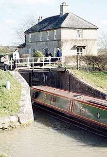
The village has two locks on the Kennet and Avon Canal, known as the Semington Locks, and is the start of the disused Wilts and Berks Canal.
Geography
Semington village developed along the main road from Melksham to Westbury which became the A350. In 2004 a bypass was opened, taking the A350 0.4 miles (0.64 km) east of the village.[3]
Little Marsh (or Littlemarsh) is a hamlet south of Semington, along the old course of the A350. Littleton is no longer populated, and the only area currently designated as belonging to Littleton is the roundabout at the A350 and A361 road crossing.
Governance
The civil parish elects a parish council. It is in the area of Wiltshire Council unitary authority, which is responsible for all significant local government functions.
The village is the most populous area of 'Summerham and Seend' electoral ward. This ward starts in the northwest at Semington, stretches south to Steeple Ashton then northeast to Seend. The total ward population at the 2011 census was 4,264.[4]
History
Canals
The Kennet and Avon Canal crosses marshy ground on an embankment on the northern edge of the village.
The two Semington locks were built between 1794 and 1802 under the supervision of the engineer John Rennie.[5] They have a combined rise/fall of 16 ft 1 in (4.9 m).[6] The two locks at Semington are known as Buckley's (numbered 15) and Barrett's (16).[7]
Next to the locks is the point at which the Wilts & Berks Canal left the Kennet and Avon. The Wilts & Berks is disused but the Wilts & Berks Canal Trust is restoring it. East of the locks, the canal travels across the 2004 Semington Aqueduct, built to allow the A350 to bypass Semington village. Another aqueduct carries the canal over Semington Brook.[8]
The canal, towpath and adjacent hedges are good for wildlife and in August 2007 water voles were seen.[9]
Former railway
The Devizes Branch Line was built 0.6 miles (0.97 km) north of the village in 1857. A small station (Semington Halt) was opened in 1906 where the railway crossed both the A350 and the Wilts & Berks canal; the station and the line were closed in 1966.
World War II
During the Second World War, Semington was on GHQ Line which followed the path of the canal. Semington was designated as a centre of resistance: extensive anti-tank ditches were constructed to the east, south, and west of the village, these were overlooked by a number of pillboxes. The defences were constructed as a part of British anti-invasion preparations.[10]
Parish church

The Church of England parish church of St George is a Grade II listed building.[11] It dates from the 15th century and was largely rebuilt in 1860.[12] There are regular services held in the church each Sunday and Bible Studies and Prayer Meetings held in homes of the village. It is a part of the Canalside Benefice which includes churches in Hilperton, Trowbridge. It has a garden fête every summer in the grounds of the Village School although Fêtes used to be held in the grounds of Brook House manor house.[13]
Amenities
Within the village there are over 500 houses, a primary school,[14] a village hall,[15] public tennis courts and a park for children.
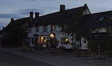
Semington has a pub, The Somerset Arms,[16] which is popular with canal travellers.
Economy
About 1 km north of the village is Hampton Park West business park, which has the corporate headquarters of companies such as G-Plan, Avon Rubber plc and a large Wiltshire Police operations centre.

Notable residents
- Isaac Gulliver (1745–1822), smuggler
- Thomas Helliker (1784–1803), trade union martyr, executed for rôle in burning Semington mill
See also
Sources
- Foot, William (2006). Beaches, fields, streets, and hills ... the anti-invasion landscapes of England, 1940. Council for British Archaeology. ISBN 1-902771-53-2.
- "Semington". Wiltshire Community History. Wiltshire Council. Retrieved 18 April 2015.
References
- ↑ "Parish population 2011". Office for National Statistics. Retrieved 18 April 2015.
- ↑ election-maps.co.uk, Semington Civil Parish boundary on Ordnance Survey 1:50,000 colour raster layer. Retrieved 23 October 2006.
- ↑ "Bypass set to open to fanfare of celebrations". Brighton. 26 March 2004. Retrieved 18 April 2015.
- ↑ "Summerham and Seend ward 2011.Retrieved 15 March 2015".
- ↑ http://www.reedboats.co.uk/canals/ken/kenh.html
- ↑ Pearson, Michael (2003). Kennet & Avon Middle Thames:Pearson's Canal Companion. Rugby: Central Waterways Supplies. ISBN 0-907864-97-X.
- ↑ Allsop, Niall (1987). The Kennet & Avon Canal. Bath: Millstream Book. ISBN 0-948975-15-6.
- ↑ Historic England. "Semington Aqueduct (435208)". Images of England. Retrieved 25 October 2006.
- ↑ "Watervoles". UK Biodiversity Action Plan. Retrieved 17 March 2007.
- ↑ Foot, 2006, pp. 291–296.
- ↑ Historic England. "Church of St. George (434833)". Images of England. Retrieved 25 October 2006.
- ↑ "Church of St. George, Semington". Wiltshire Community History. Wiltshire Council. Retrieved 18 April 2015.
- ↑ Historic England. "Manor House (435211)". Images of England. Retrieved 25 October 2006.
- ↑ "St George's Church of England Primary School, Semington". Retrieved 18 April 2015.
- ↑ "Semington Village Hall". The Charity Commission. Retrieved 18 April 2015.
- ↑ Historic England. "Somerset Arms (435210)". Images of England. Retrieved 25 October 2006.
External links
| Wikimedia Commons has media related to Semington. |
Canal:
Community:
- www.semington-village.co.uk — Unofficial village website; includes parish council minutes and voluntary organisations
History:
- Semington at Wiltshire Community History from Wiltshire Council