Westbury White Horse


The Westbury or Bratton White Horse is a hill figure on the escarpment of Salisbury Plain, approximately 1.5 mi (2.4 km) east of Westbury in Wiltshire, England. Located on the edge of Bratton Downs and lying just below an Iron Age hill fort, it is the oldest of several white horses carved in Wiltshire. It was restored in 1778, an action which may have obliterated another horse that had occupied the same slope. A contemporary engraving from the 1760s appears to show a horse facing in the opposite direction that was rather smaller than the present figure. There is however, no documentary or other evidence for the existence of a chalk horse at Westbury before 1742.
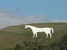
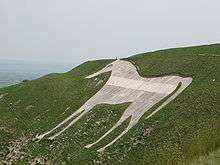
The horse is 180 feet (55 m) tall and 170 feet (52 m) wide and has been adopted as a symbol for the town of Westbury, appearing on welcome signs and the logo of its tourist information centre. It is also considered a symbol for Wiltshire as a whole.
Origins
.svg.png)
The origin of the Westbury White Horse is obscure. It is often claimed to commemorate King Alfred's victory at the Battle of Ethandun in 878, and while this is not impossible, there is no trace of such a legend before the second half of the eighteenth century. Since the late 19th century historians have mostly located the battle of Ethandun at Edington in Wiltshire, some two miles away from the white horse, but this theory is still open to debate.
Another hillside chalk figure, the Uffington White Horse, featured in King Alfred's early life. He was born in the Vale of White Horse, not far from Uffington. Unlike the recorded history of Westbury, documents as early as the eleventh century refer to the "White Horse Hill" at Uffington ("mons albi equi"), and archaeological work has dated the Uffington White Horse to the Bronze Age, although it is not certain that it was originally intended to represent a horse.
A white horse war standard was associated with the continental Saxons in the Dark Ages, and the figures of Hengest and Horsa who, according to legend, led the first Anglo-Saxon invaders into England, are said to have fought under a white horse standard (a claim recalled in the heraldic badge of the county of Kent).
During the eighteenth century, the white horse was a heraldic symbol associated with the new British Royal Family, the House of Hanover, and it is argued by some scholars that the Westbury White Horse may have first been carved in the early eighteenth century as a symbol of loyalty to the new Protestant reigning house.
In Alfred and the Great White Horse of Wiltshire (1939), the Downside Abbey monk Dom Illtyd Trethowan debunked the suggested connection of the White Horse with Alfred and the Battle of Ethandune.[1] Paul Newman suggests in his book Lost Gods of Albion (2009) that the horse may have been inspired by the popularity of folly buildings in the 18th century.
Wiltshire folklore has it that when the nearby Bratton church clock strikes midnight, the white horse goes down to the Bridewell Springs,[note 1] below the hill, to drink.[2]
Modern history
By 1872 the horse was considered to have lost shape, by the chalk repeatedly growing over and being recut. In 1873 it was remodelled by a committee, and at the same time substantial edging-stones were added all around the perimeter, to prevent the shape from changing again.[3]
The horse was illuminated at night in 1900 and again in 1950, both times using army equipment. For the 1950 event, traffic in Westbury and Bratton came almost to a standstill as drivers slowed down to look.[4]
In the 1950s the horse was concreted over by Westbury Urban District Council, apparently as a way to save on long-term maintenance costs.[3] Since then, the concrete has greyed over time, and it was thoroughly cleaned in 1993.[5] In 2003, the horse was vandalised when "Stop This War" was written in yellow across the horse in capital letters in protest of the Iraq War. After the words were removed, the horse was noticeably grey with a white horizontal strip where the message had been. In November 2006, the horse was repainted and the 1950s damage was fully repaired, as was the white strip. The newly whitened horse was illuminated for a third time on the night the repairs were finished, this time by Second World War searchlights. In July 2010, the neck of the horse was vandalised when the word "wonkey" was written across it.[6] This part of the neck had to be rewhitened in 2010, leading to the horse having a whiter neck than the rest of the body.
The BBC reported on 2 March 2012 that the horse was to be cleaned again in 2012.[7] Work began 11 April 2012 and was completed 19 April 2012. The cleaning coincided with the Diamond Jubilee of Queen Elizabeth II.[8] Celebrating the completion of the work, again the horse was lit up with searchlights.[8] Since the annual Village Pump Festival moved from Farleigh Hungerford to the White Horse Country Park beneath the horse in 2012, the horse has been illuminated at night whilst the festival has been taking place. This is achieved via a tinted spotlight which changes colour every couple of seconds, so the horse appears different colours.
Two visitors' information signs, on the hill above the horse and in the Viewing Area car park, were placed in 1999 following the completion of Devizes White Horse; the signs show all eight Wiltshire White Horses. Also on the side of the hill is a toposcope dated 1968, mounted on a small stone structure, which identifies the towns and cities that can be seen from the hillside.[9] For the Golden Jubilee of Queen Elizabeth II, a fire beacon was placed to the side of the road on the top of the hill leading to the car park on 3 June 2002,[10] that resembles the millennium beacons.[11] It is lit sporadically, and most recently for the 70th anniversary of VE Day on 8 May 2015.[12]
Views
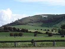
The Horse can be viewed from up to 16–17 miles in all directions. From the horse, Westbury and Trowbridge can be closely observed. From the top of the horse and Bratton Castle, Devizes White Horse and Alton Barnes White Horse can both be viewed. The horse itself cannot be seen from other hill figures, although it can be viewed from Solsbury Hill, home to a small turf maze carved in the 1990s. One of the furthest views of the horse is said to be from Beckford's Tower in Bath.
A car park on Bratton Road on the B3098 which passes beneath the horse is known as Westbury White Horse Viewing Area.[13] It has fifteen parking spaces and information boards on the horse.
From 1961 to 2016, a 400 feet (122 metres) tall chimney at the Lafarge cement works stood about a mile and a half away from the horse. Built for Blue Circle, a company bought by Lafarge in 2001, the chimney was made defunct in 2010 and was demolished on 18 September 2016.[14] Some considered it an eyesore whilst others considered it a local icon, a debate covered by a BBC Wiltshire radio broadcast in 2011.[15] Many further views of the horse also included the chimney and the chimney was the most prominent feature of the view from the horse; some considered the chimney to spoil views from the hill.[16] As the horse has been vandalised several times, so too the chimney was defaced in 2010 by the addition of a Union Jack flag.[17]
The landscape of the horse was threatened in 2013 when Wiltshire Council revealed plans for a potential three-lane bypass that would run within half a mile of the horse, with a 35-acre business park and 550 new homes on Green Belt land.[18] Some local residents, together with many from outside the town, were against the "Swindonisation" of their corner of West Wiltshire although many residents felt that Westbury, as the only town on the A350 without a bypass and whose medieval heart was blighted by pollution and HGVs needed a bypass. The issue still divides the town.
Battle of Ethandun Memorial

Although the horse is only presumed to commemorate King Alfred's victory at the Battle of Ethandun, an official monument to the victory was erected atop the hill, adjacent to Bratton Camp. The monument does not have an official name but is known as the Battle of Ethandun Memorial. It consists of a large sarsen stone (stone of remembrance) with a "pebbled" base, on which lies a metal commemorative plaque. The monument was unveiled 5 November 2000 by the 7th Marquess of Bath.[19]
King Alfred's Tower, near Stourhead, is the best known monument that was definitely built to celebrate King Alfred and his victory. The folly tower was erected in 1772, six years before the white horse was redesigned.
In popular culture

The White Horse was referenced in the books The Tontine (1955) by Thomas B. Costain, The Emigrants (1980) by Caribbean author George Lamming, and in the novel The English Patient (1992) by Michael Ondaatje, as the place where the sapper Kip learned how to deactivate bombs.
The figure can be seen in the music video for Scottish guitarist Midge Ure's 1996 single "Breathe", and is featured in the current opening titles of the regional television news programme ITV News West Country. Furthermore, it featured in a 2015 Visit England tourist advertisement produced in association with the England rugby team.
The horse lends its name to White Horse Business Park outside Trowbridge and White Horse Country Park outside Westbury. The horse overlooks both parks. White Horse Way is also a name of a street in Westbury, and the town's visitor centre features the horse in its logo, as does its golf club.[20] The horse is included in a mosaic on the town's Morrisons outlet in Edward Street, which was placed to commemorate the links between the youth of Westbury and the Chernobyl area.
See also
References
- ↑ Illtyd Trethowan, 'Alfred and the Great White Horse of Wiltshire', in Downside Review vol. LVII (1939)
- ↑ "Wiltshire White Horses". wiltshirewhitehorses.org.uk.
- 1 2 The Westbury or Bratton white horse at wiltshirewhitehorses.org.uk, accessed 10 October 2016
- ↑ Wiltshire White Horses: lighting up the horses at wiltshirewhitehorses.org.uk, accessed 10 October 2016
- ↑ "BBC - Wiltshire - In Pictures: Westbury White Horse Lit". bbc.co.uk.
- ↑ http://www.westburypeople.co.uk/groups/westbury-sights/Graffiti-Westbury-White-Horse/story-6106401-detail/story.html
- ↑ "Westbury white horse to be cleaned for Queen's Jubilee". BBC News.
- 1 2 "Westbury's greying hillside white horse to be repainted". BBC News.
- ↑ Gittins, Roger (19 May 2009), Westbury White Horse. The construction in the foreground is a signpost erected by pupils of Adcroft School of Building in 1968., retrieved 18 September 2016
- ↑ Caroline Davies (22 May 2002). "World to light beacons to honour Queen". Telegraph.co.uk.
- ↑ "BBC News - UK - Beacons blaze across UK". bbc.co.uk.
- ↑ "Westbury's White Horse to mark 70th anniversary of VE Day with beacon lighting". Wiltshire Times.
- ↑ "Country parks and open spaces". Wiltshire Council.
- ↑ Mackley, Stefan (18 September 2016). "Westbury chimney: Emotions run high following demolition". Wiltshire Times. Retrieved 18 September 2016.
- ↑ "BBC Wiltshire - Matthew Smith, Westbury cement works chimney: eyesore or icon?". BBC.
- ↑ "Wiltshire White Horses". wiltshirewhitehorses.org.uk.
- ↑ "Stunt flags up security issue at Westbury". Wiltshire Times.
- ↑ James Fielding. "Council planners want to ruin Westbury White Horse with bypass". Express.co.uk.
- ↑ "War Memorial: Battle Of Ethandun (45340)". Imperial War Museums.
- ↑ Westbury Golf Club - Home
- Reverend Francis Wise, Further Observations on the White Horse and other Antiquities in Berkshire (1742)
- William Plenderleath, White Horses of the West of England (1885, 2nd edition 1892)
- Morris Marples, White Horses and Other Hill Figures (1949)
- Westbury White Horse at Wiltshire White Horses
- The White (ish) Horse at ThisisWestbury.co.uk, Westbury's history website
- Wiltshire Web information
Notes
- ↑ Bridewell is pronounced locally as if it is spelt "Briddle", and as such, the springs are also known as the Briddle Springs.
Bibliography
- Plenderleath, Rev. W. C., The White Horses of the West of England (London: Allen & Storr, 1892)
Coordinates: 51°15′49″N 002°08′49″W / 51.26361°N 2.14694°W