Žuniči
| Žuniči | |
|---|---|
 | |
 Žuniči Location in Slovenia | |
| Coordinates: 45°28′55.3″N 15°21′38.55″E / 45.482028°N 15.3607083°ECoordinates: 45°28′55.3″N 15°21′38.55″E / 45.482028°N 15.3607083°E | |
| Country |
|
| Traditional region | White Carniola |
| Statistical region | Southeast Slovenia |
| Municipality | Črnomelj |
| Area | |
| • Total | 1.55 km2 (0.60 sq mi) |
| Elevation | 195.6 m (641.7 ft) |
| Population (2002) | |
| • Total | 49 |
| Climate | Cfb |
| [1] | |
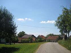
Žuniči (pronounced [ˈʒuːnitʃi]; in older sources also Žuniče,[2] German: Schunitsche[2]) is a settlement on the left bank of the Kolpa River in the Municipality of Črnomelj in the White Carniola area of southeastern Slovenia. The area is part of the traditional region of Lower Carniola and is now included in the Southeast Slovenia Statistical Region.[3]
A small chapel in the settlement is dedicated to Saint Nicholas (Slovene: sveti Miklavž) and belongs to the Parish of Preloka. It was built in the early 20th century.[4]
References
- ↑ Statistical Office of the Republic of Slovenia
- 1 2 Leksikon občin kraljestev in dežel zastopanih v državnem zboru, vol. 6: Kranjsko. 1906. Vienna: C. Kr. Dvorna in Državna Tiskarna, p. 10.
- ↑ Črnomelj municipal site
- ↑ Slovenian Ministry of Culture register of national heritage reference number ešd 2175
External links
 Media related to Žuniči at Wikimedia Commons
- Žuniči on Geopedia

This article is issued from Wikipedia - version of the 7/2/2016. The text is available under the Creative Commons Attribution/Share Alike but additional terms may apply for the media files.