Adlešiči
| Adlešiči | |
|---|---|
|
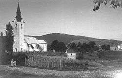
Adlešiči in 1920 | |
 Adlešiči Location in Slovenia | |
| Coordinates: 45°31′20.63″N 15°18′39.76″E / 45.5223972°N 15.3110444°ECoordinates: 45°31′20.63″N 15°18′39.76″E / 45.5223972°N 15.3110444°E | |
| Country |
|
| Traditional region | White Carniola |
| Statistical region | Southeast Slovenia |
| Municipality | Črnomelj |
| Area | |
| • Total | 1.58 km2 (0.61 sq mi) |
| Elevation | 212.6 m (697.5 ft) |
| Population (2002) | |
| • Total | 126 |
| Climate | Cfb |
| [1] | |
Adlešiči (pronounced [ˈaːdlɛʃitʃi]; German: Adleschitz[2]) is a settlement on the left bank of the Kolpa River in the Municipality of Črnomelj in the White Carniola area of southeastern Slovenia. The area is part of the traditional region of Lower Carniola and is now included in the Southeast Slovenia Statistical Region.[3] It also encompasses a hamlet to the east near the bank of the Kolpa River called Nabrežci (literally, 'on the bank'), also known as Nabreško Selo (Slovene: Nabreško selo, literally 'settlement on the bank').[4]
The local parish church is dedicated to Saint Nicholas (Slovene: sveti Miklavž) and belongs to the Roman Catholic Diocese of Novo Mesto. It was first mentioned in written documents dating to 1334, but owes its current Baroque look to a major remodelling in the second half of the 18th century. The main altar dates to 1782.[5]
References
- ↑ Statistical Office of the Republic of Slovenia
- ↑ Leksikon občin kraljestev in dežel zastopanih v državnem zboru, vol. 6: Kranjsko. 1906. Vienna: C. Kr. Dvorna in Državna Tiskarna, p. 4.
- ↑ Črnomelj municipal site
- ↑ Savnik, Roman, ed. 1971. Krajevni leksikon Slovenije, vol. 2. Ljubljana: Državna založba Slovenije. p. 21.
- ↑ Slovenian Ministry of Culture register of national heritage reference number ešd 1595
External links
| Wikimedia Commons has media related to Adlešiči. |
