Yerakini
| Yerakini Γερακινή | |
|---|---|
|
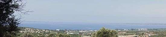
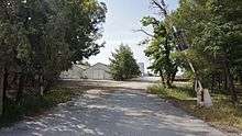
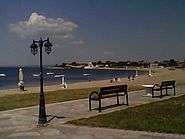
Yerakini as seen from the west | |
 Yerakini | |
| Coordinates: 40°17′N 23°27′E / 40.283°N 23.450°ECoordinates: 40°17′N 23°27′E / 40.283°N 23.450°E | |
| Country | Greece |
| Administrative region | Central Macedonia |
| Regional unit | Chalkidiki |
| Municipality | Polygyros |
| Government | |
| • Mayor | Asterios Zografos (Greek: Αστέριος Ζωγράφος [asˈteɾios zoˈɣɾafos]) (of Polygyros) |
| Highest elevation | 100 m (300 ft) |
| Lowest elevation | 0 m (0 ft) |
| Population (2011)[1] | |
| • Municipality | 22,048 (of Polygyros) |
| • Municipal unit | 11,386 (of Polygyros) |
| Time zone | EET (UTC+2) |
| • Summer (DST) | EEST (UTC+3) |
| Postal code | 631 00 |
| Area code(s) | +30 23710 |
| Vehicle registration | ΧΚ |
| Website | http://www.interalex.net/search?q=yerakini |

Yerakini or Gerakini (Greek: Γερακινή, Greek pronunciation: [ʝeɾaciˈni]) [2] is a village in the Chalkidiki peninsula in Central Macedonia, Northern Greece.[3]
It has been the port[4] [5] of nearby Polygyros, the capital town of Chalkidiki, ever since its settlement. Its beaches attract thousands of tourists and holidaymakers during the summer. It has the largest magnesite deposits in Northern Greece.
Etymology
The word Γερακινή (Yerakini) comes from γερακίνα (yerakina ([jeɾaˈcina]) meaning female peregrine falcon (falcon-gentle) (from γεράκι ([jeˈɾaci]), from ιέραξ ([iˈeɾaks]) falcon).[6] There is a legend that the name came from a queen named Yerakina (Gerakina) who lived in Yerakini once.
Geography
Location
Yerakini lies on the gulf of Torone, between the two fingers (smaller peninsulas) of Kassandra and Sithonia, southeast of Thessaloniki. [7]
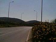
Yerakini is at a distance of 14.5 km (9 mi.) from Polygyros, 77 km (48 mi.) from Thessaloniki, via Polygyros, or 78 km, via Nea Moudania, and 66 km (41 mi.) from the Thessaloniki International Airport. [8] Its geographical position offers the option to travelers to travel to and from Thessaloniki either by the frequent bus route (from Thessaloniki to Sarti) (KTEL), or by car or other vehicle, via Polygyros or Nea Moudania.

Climate and weather
The climate is Mediterranean, temperate[9][10] throughout the year with mild winter in Yerakini (very rarely below 0 °C), serene sky for most part of the year,[11][12] which also contributes considerably to the growing of olives[13] [14] in the area, also allowing shepherds from other regions, especially in the past, to winter their flocks of sheep and goats and other animals there. Average temperature ranges from lowest 10 degrees (°C). in winter (Jan Feb) to highest 35 degrees (°C). in summer (Jul Aug). [15][16][17][18]
Environment
Environment has greatly affected all people. Natural Resources, climate and the sea have been the biggest factors that affected the people who have lived and worked in Yerakini area.
Economy
There are three kinds of occupation of the people, corresponding to its three parts.

- Agriculture: farming,[19] chiefly for green olives. It is the center of olive growing in Chalkidiki, hence the first green olive preservation plant of Chalkidiki established there by the government in the seventies. Olive husbandry has developed rapidly in recent years as monoculture of the farmers.
- Tourism the principal occupation in the summer, for all those, inhabitants of Yerakini or from other areas, involved in tourist services and products at the seaside such as accommodation, food, and folk product shops.
- Mining of magnesite for workers mostly commuting from other areas of Chakidiki, mainly from Zervochoria (Greek: Ζερβοχώρια [zeɾvoˈxorʝa], villages in the north of Chalkidiki).
Its geographical position is a plus for future business development in tourism and other activities (central depots, cash and carry, shopping malls etc.).
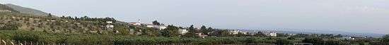
Village
The middle part, the real village of Yerakini, has the church of patron saints Agioi Theodoroi (dedicated to two saints having the same name Theodoros).

The annual feast day commemorating the saints is held on the first Saturday of Lent, the religious church service officiated by Metropolitan Nicodemus of Kassandreia,[20] the people celebrating with a number of activities also at the seaside.

There has been a town plan for the area between the village and the seaside for many years, no streets can one see though. All land (fields, plains and slopes as well as the biggest part of the Trikorfo (three peaks) mountain in the east, 3.5 km away from Yerakini) is covered with olive-groves. The inhabitants are farmers principally growing olives for the table and their oil.

There are several olive oil mills in the area (in Polygyros, Kalyves Polygyrou, Olynthos, Ormylia) and companies for green table olives preservation. Olives are harvested while green for table olives in September and, mainly for olive oil, when black in November and December. The language spoken is the Greek dialect of Chalkidiki, as spoken in its capital Polygyros. Yerakini has a soccer team, which plays against other teams of Chalkidiki. Although the village itself is not tourist-oriented, holidaymakers visit it especially for the Divine Liturgy (The Sunday Mass of the Orthodox) of the church and on saints' feast days.

History
Yerakini as well as nearby Kalyves Polygyrou were settled by farmers from Polygyros in the late 1800s and early 1900s, ever since belonging to its municipal administration as municipal units.
Until the 1960s there was the sole olive oil mill of the area on the central beach owned by the Haji Osman family. There was also a police station in Yerakini for very many years in the past. During World War II there was the Administration Center of the area, which, among other activities, extended the main dock, whose remains still extant, for vessel freights for use by the occupying German army. Divers and amateur fishers used both parts of the dock for diving and fishing. There was also a lighthouse on the right side of the main dock.
Seaside
The southern part, the sea-side of Yerakini (Παραλία Γερακινής, [paɾaˈlia ʝeɾaciˈnis]) where the Customs Office is situated. It is a part of the coastline stretching from Psakoudia (Ψακούδια [psaˈku ðʝa]) (5 km from Yerakini) in the east, to Kalyves Polygyrou in the west. Yerakini coast covers the area between Trikorfo beach (formerly known as "Tou Iatrou i Kalyva" locally τ’ Ιατρού η καλύβα) and that of "Kalamaras and Pangalos" summer residences (formerly "Tou Mourlakou to Pigadi", "Mourlakos' Well", locally Greek: τ’ Μουρλακ του πγιάδ [tmurˈlak du ˈbʝað]).[21]
Beaches

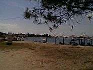
The seaside consists of three parts, of very clean long white sandy beaches, small or big bays : the central, the eastern and the western being the longest one extended up to Kalyves Polygyrou beach, and many more smaller ones east) of clear blue waters.
The eastern seaside (between the central beach and Psakoudia) consists of Gerakina Beach, Douros Residences (Gerakini Mare), Kipoupolis (Garden Town), Porto Maria, Kouyoni beach, Sonia Village Beach, Galini and Trikorfo beach. The western seaside (between the central beach and the Mecyberna [22] complex) consists of Lazaridika, Megika, Bazakeika (Martha Haus), Katsarou, Goloika, The Well (Pigadi), Nea Kalyvia, Alkinoos, Poseidon, Scorpios, Toronis, Amphitrite, Gerania and Sermyle Complex, Sermyle Complex, Gerania, Amphitrite, Toronis, Scorpios, Poseidon, Alkinoos, Nea Kalyvia and Molyvopyrgos beaches. It has bay beaches and inlets especially at the eastern rocky sea-coast joining the pine wooded Psakoudia beach, the main beach of Ormylia's.

Yerakini's seaside is one of the main vacation resorts of Chalkidiki and attracts thousands of visitors from April to October. It can be reached by bus or car from Thessaloniki via Polygyros or Nea Moudania, or by sea by passing through Potidaia's canal, or by the primary opening between the two fingers of Kassandra and Sithonia. It has a mooring bay on the Aegean Sea .

Holidaymakers from other European countries visit for the recreational facilities; there is accommodation of various types, places to eat, and sporting and seaside entertainment and activities. In summer the population increases by ten to twenty times.
Yerakini is a departure point for exploring Chalkidiki, with easy access to the peninsula and excursions to the three smaller peninsulas, Kassandra, Sithonia, and Porto Carras. Mount Athos is to the east, Stageira, Aristotle's birthplace, to the northeast, the archeological sites of Olynthus and Potidea, Petralona cave to the west, and densely wooded Mount Cholomon 15 km north. Thessaloniki, the Byzantine historical city and capital of Greek Macedonia is to the northwest.
Seaside tourism
Tourism in Chalkidiki officially began in the late 1950s (Tourism Development Plan by PM Konstantinos Karamanlis), and in the late 1960s it was declared one of four areas of “Prime Zone for Tourism Development in Greece”, the other three being Corfu, Rhodes and Crete.
The people of Polygyros and other villages in the north used to go swimming mainly to Yerakini central beach in the 1950s, also until today. Yerakini seaside area was inhabited for many years by a number of year-round residents (mostly fishermen in the past), some taverners and the customs officer's family. The first foreigners who visited Yerakini as a seaside resort were directors of the Anglo-Greek Magnesite Co. Ltd. and their families in the early years of he twentieth century, who had summer cottages by the sea, and crew members of the small bulk cargo vessels that used to arrive from abroad for freighting magnesite.

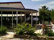
The Yerakini seaside began its development in 1959 when the official tourism development began and the first public tourist pavilion started operating at the seaside. Similar pavilions opened in Olympiada and Ierissos. In the early 1970s the first hotel and bungalows summer resort in Chalkidiki, Gerakina Beach Hotel, opened at the eastern beach, 600 m from the central beach (currently operating, after reconstruction, under the new trade name Ikos Olivia), and later more accommodation and other facilities were built for the increasing number of holidaymakers.
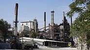
Magnesite mines

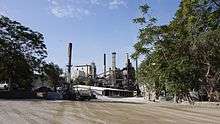
In the northern part, the mines of Yerakini, most residents are workers and technicians working at plants of the large Grecian Magnesite company, established in 1959, which mines ore, the raw material of magnesite. [23]
The company operates many open-cast quarries in the area to the north, processes magnesite, and exports of products derived from caustic magnesia. It employs about 300 people.
The company is 600 metres (0.37 mi) from the village, the kilns 800 metres (0.50 mi) away, and the quarries 1–3 kilometres (0.6–2 mi). Vessels come to the Nea Moudania harbour, 17 kilometres (11 mi) from Yerakini, on the Thermaic gulf, before the peninsula of Kassandra, to load magnesite

Magnesite plant southern side
History of the magnesite mines
The Yerakini area has the most extensive deposits of magnesite in Greece in many parts and particularly in the north and northeast, making underground wealth an attraction for exploitation by Greek and foreign companies, which have exploited the deposits for more than 100 years with opencast mining quarries, kilns etc. Crude magnesite was produced in Greece in 1910. It was first found in Atalanti and in the Province of Lokris, central Greece. The Anglo-Greek Magnesite Co. Ltd [24] (AGM) was the first mining operator in Yerakini. In 1959 G. Portolos (Grecian Magnesite) bought the magnesite operations and continued the exploitation of magnesite deposits. There are also other minor magnesite mining deposits especially in the southwestern foothills of Trikorfo mountain exploited by Antoniou and Xenakis concern for a long period in the 1950s and 1960s. Other localities were Perachori, near Corinth; Ermioni (or Kastri) and on Spetses Island in southern Argolis in the Peloponnese; on Paros Island (Cyclades); around Thebes (Thiva), in Boeotia (Viotia) and in Papades [25] and Troupi [26] in northern Euboea (Evia). Euboea (Evia island) was mostly worked until the 1980s.
Galataki (near Limni) and Afrati (near Halkida) were exploited by the English company Petrified Ltd., which sold its assets to AGM in 1902. Northern Greece was also found to have magnesite, in the concessions of Aghia Paraskevi (east of Thessaloniki) in small production, and in Chalkidiki’s concessions of Vavdos, [27] Patelidas [28] (11.5 km far from Yerakini), and Yerakini with the largest deposits.
Bulk carriers from all over the world used to come to Yerakini port's two docks at the central beach bay; several hoys (a sort of barge no longer used) would take the raw magnesite from the docks to the vessels anchored in deep waters. Now only the hoys and the right dock, with its old storehouses (depots), remain.
Brief history of The Anglo-Greek Magnesite Co. Ltd
Anglo-Greek (AGM) purchased the assets of the English company Petrified Ltd with mines at Galataki (near Limni) and Afrati (near Halkida) of Euboea in 1902. AGM also acquired the assets of the Societe Hellenique des Mines de Magnesite, with mines at Limni, Mantoudi, and Pyli village on the east coast of Euboea island, in 1912. The raw material was shipped by the Galataki harbour.

AGM ceased its activity on Euboea island after World War II, the railway it employed (750 mm and 600 mm gauge) was dismantled and the rolling stock was sold for scrap, today some ruined parts still existing. The Anglo-Greek Magnesite Co. Ltd was the principal operator for the first half of the twentieth century in Greece. In 1922 it also purchased the Yerakini concession, producing 27,000 tons of raw material per year. The deposits were estimated at 300,000 tons in 1947. It used coal and brushwood as well as trunk wood for fuel of its kilns

The Yerakini mines about 3 km inland from the Gulf were reached by means of a narrow-gauge (565 mm) railway, used also by the new owners until the 1980s. The Anglo-Greek Company operated a power system supplying electricity in the mines area in the fifties. It organized various events and activities, such as soccer matches, weekend balls etc. In 1959 it sold its assets to the Greek-owned Portolos Co.
Natural resources
The soil of Chalkidiki is very rich in ore minerals such as gold, magnesite, an ore, a valuable mineral mainly in the form of white stone (metallic commodity) existing with other minerals (such as iron, chromium etc.).
Magnesite of Chalkidiki is mostly pure, not mixed with other materials, its colour being white, hence its name. The subsoil in the area of Yerakini as well as of Patelidas and Vavdos is rich in magnesite.
The topsoil is suitable for olive cultivation and hence the principal occupation of the people from the village and other towns. The surface soil is suitable for growing other crops, too.
Gallery
 |
 |
|
| Central Beach as seen from the eastern end of the pedestrian walk | T junction from Polygyros road | Magnesite Hoys onshore |
 |
 |
 |
| Magnesite storehouses onshore | Trikorfo mountain of Yerakini | Part of the eastern beach |
 |
|
 |
| Gerakina Beach Hotel and Bungalows gate | Tourist Pavilion, currently a tavern and bar | Central beach as seen from the main dock |
 |
 |
|
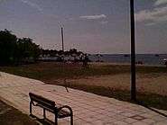
| Pedestrian walk at the seaside | Part of the central beach | Part of the central beach |
 |
 |
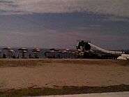 |
| Central Beach of Yerakini | Magnesite storehouses onshore | Part of the central beach |
 |
 |
 |
| The main dock “Skala” | Driving west of Yerakini | Central beach as seen from the eastern end of the pedestrian walk at the seaside |
 |
 |
 |
| Central beach from eastern end of pedestrian walk | The Trikorfo beach, part of eastern coast | Part of eastern coast |
 |
 |
 |
| The Trikorfo mountain as seen from the main road | The Elementary School of Yerakini | The Church of Patron Saints Agii Theodori |
 |
 |
 |
| Agii Theodori Church of Yerakini | Yerakini main road joining square | Yerakini main road |
 |
 | |
| Yerakini Magnesite Plant northern side | Yerakini Magnesite quarries | Yerakini Magnesite quarry |
 |
 |
|
| Yerakini Central Beach | Yerakini Central Beach | The Gulf of Torone |
See also
References
- ↑ "Απογραφή Πληθυσμού - Κατοικιών 2011. ΜΟΝΙΜΟΣ Πληθυσμός" (in Greek). Hellenic Statistical Authority.
- ↑ Pronunciation:
Pronunciation in IPA phonetic transcription in English, standard Greek, and local dialect.(English pronunciation is defined between slashes / / (broad phonemic transcription) while Greek or local pronunciation is defined between square brackets [ ] (narrow, allophonic transcription) See Narrow and Broad Transcription)
English pronunciation:
- Chalkidiki, Chalkidike, Khalkidiki, Khalkidhiki, Khalkidike
 i/hælˈkɪdiˌki/, i/kælˈkɪdiˌki/, i/hɑːlkiðiˈki/ (Greek pronunciation of the word Chalkidiki or Halkidiki as pronounced by the British); or Chalcidice, i/kælˈsɪdəsi/; or Halkidiki, i/hælˈkɪdiˌki/
 - Polygyros, i/pəˈliɡiˌrɒs/
- Yerakini, rarely Gherakini, i/ˌjɛrəˈkini/; or Gerakini, Gerakine,i/ˌɡɛrəˈkini / or i/ˌdʒ ɛrəˈkini/
(Modern Greek phonology by Amalia Arvaniti) (Ancient Greek and Modern Greek pronunciations).- Χαλκιδική, Greek: [ xalciðiˈci ], locally [ xalciðˈci ]
- Πολύγυρος, Greek: [ poˈlijiɾos ], locally [ puˈʎijiɾus ]
- Γερακινή, Greek: [ jeɾaciˈni ], locally [ʝi racˈɲi ]
- Chalkidiki:\halˌkjidiˈkji\, \halˌkeedeeˈkee\
- Polygyros:\poˈleeyeeˌros\
- Yerakini: \jeˌrakjiˈnji\ \yeˌrakeeˈnee\
- Chalkidiki, Chalkidike, Khalkidiki, Khalkidhiki, Khalkidike
- ↑ Kallikratis Law Greece Ministry of Interior retrieved 2014-07-15
- ↑ Port Directory Yerakini port retrieved 2014-07-15
- ↑ Port of Yerakini, Greece retrieved 2014-07-15
- ↑ Greek Encyclopedia TOME (Gr. ΤΟΜΗ), volume 4, p. 111
- ↑ Yerakini is amidst Nea Potidaia (1559), Agios Mamas (841), Kalyves Polygyrou (1333), (Population of Kalyves Polygyrou is a total with Yerakini’s in the last Census of 2011) Yerakini, Psakoudia (299), Metamorfosi (Metamorphosi) (531) and Nikiti (2711), which comprise the Gulf northern sea-side villages.
- ↑ Driving distance from villages, towns and localities.
Population as of 2011 Census.
Place Km Pop Location Agios Mamas 10.30, 12 1059 Inland Agios Nikolaos 32.43 1714 Inland Aphytos 37.90 1273 Coast Athens 576.62 664046 Inland Cholomondas 41.89 - Inland Kallithea 39.88 1179 Coast Kalyves Polygyrou 4.5, 5.98 1333 Coast Kassandreia 44.40 2775 Inland Nea Moudania 17.19 9342 Coast Nea Phokea 31.62 1944 Coast Nea Potidea 21.73 1559 Coast Nikiti 23.62 2711 Coast Neos Marmaras 44.30 3158 Coast Ormylia 13.18 2979 Inland Ouranoupoli 74.45 826 Coast Patelidas 11.5 5 Inland Petralona 35.04 348 Inland Polygyros 14.5 6121 Inland Psakoudia 5, 6.99 299 Coast Sarti 65.95 1156 Coast Stagira New 65.51 352 Inland Stagira Old 80.39 - Coast Sykia 77.29 1903 Inland Thessaloniki 77 315196 Coast Thessaloniki Airport 65.89 - Coast Toroni 63.72 213 Coast - ↑ Halkidiki Annual Weather Averages retrieved 2014-11-25
- ↑ Data of Yerakini retrieved 2014-11-01
- ↑ Yerakini Weather retrieved 2014-11-05 Usually when it pours or snows in Polygyros and other neighboring towns or villages, the sky is unclouded, clear in Yerakini
- ↑ Weather by Yafoo retrieved 2015-01-23
- ↑ Olive Cultivation in the Mediterranean retrieved 2014-07-17
- ↑ Cultivation of Chalkidiki Olives retrieved 2014-07-17
- ↑ Yerakini weather forecast retrieved 2014-07-22
- ↑ Yerakini Weather now and for a predicted period retrieved 2014-07-22
- ↑ Yerakini holiday weather retrieved 2014-07-22
- ↑ Yerakini weather the year round retrieved 2014-11-05
- ↑ Olive tree farming in Greece
- ↑ Metropolis of Kassandreia retrieved 2015-02-05
- ↑ Marine Wind and Wave chart for Yerakini | Marine Weather retrieved 2014-08-12
- ↑ Mecyberna retrieved 2015-06-07
- ↑ Magnesite (Magnesite Encyclopædia Britannica, Magnesite University of Alaska, Natural Sciences Magnesite Single-crystal elasticity of the deep-mantle magnesite at high pressure and temperature, Jing Yanga, Zhu Maoa, Jung-Fu Lina, Vitali B. Prakapenka Materials engineering) is a white, amorphous rock dense in structure, processed for use by industries. Used as a raw material as well as after altering its properties by very high heating (for the production of a new material for special uses). Magnesite and dolomite minerals are used to produce refractory bricks. Beneficiation process (separating ore into mineral and gangue) employed and either exporting it as raw material (magnesium carbonate), or calcination, or deadburning follows for caustic calcined magnesia (reactive material) or deadburned magnesia (sintered magnesia) (a non-reactive material), respectively in order to make raw magnesite suitable for various uses. Magnesium carbonate (MgCO3) (An inorganic salt, a white solid ) is used for the production of magnesium oxide (MgO) by calcining. MgCO3 is used at industrial applications, agricultural industries, the pulp and paper industry, the pharmaceutical industry and in the manufacture of rubber (as reinforcing agent in neoprene rubber), paints and plastics (as smoke suppressant), flooring, fireproofing, fire extinguishing compositions, dusting powder, cosmetics and toothpaste, antacid, additive in table salt). In addition, as filler material, a drying agent, a laxative to loosen the bowels, (Milk of Magnesia) and color retention in foods. Deadburned magnesia, with its refractory (non-reactive) properties is used where (very) high temperature is needed (the steel industry, line blast furnaces, heat-proof bricks manufacturing, electrical applications (e.g. kettles and boilers).
- ↑ Anglo-Greek Magnesite Co Ltd
- ↑ Papades of Evia retrieved 2015-06-07
- ↑ Troupi retrieved 2015-06-07
- ↑ Vavdos retrieved 2015-06-01
- ↑ Patelidas retrieved 2015-06-01