Windauer Ache
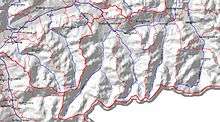 | |
| The diagram shows the course of the Windauer Ache, which flows in a northerly direction - from the Salzburg border to Hopfgarten. | |
| Location | in the Windautal / Kitzbühel Alps, |
|---|---|
| Length | 21 km |
| Source | Rainkarsee on the Kröndlhorn 47°18′25″N 12°10′15″E / 47.30694°N 12.17083°ECoordinates: 47°18′25″N 12°10′15″E / 47.30694°N 12.17083°E |
| Source height | 2,200 m (AA) |
| Mouth | In Haslau / Hopfgarten into the Brixentaler Ache 47°26′17″N 12°10′18″E / 47.43806°N 12.17167°E |
| Mouth height | 630 m (AA) |
| Descent | 1,570 m |
| Basin | Danube |
| Progression | Brixentaler Ache → Inn → Danube → Black Sea |
| Catchment | Windautal |
| Right tributaries | Miesenbach, Rettenbach |
| Left tributaries | Falberbach, Dürrnbach |
| Lakes passed | Reinkarsee |
| Villages | Westendorf and Hopfgarten |
The Windauer Ache is a mountain stream in the scenic Windautal valley in the Kitzbühel Alps in Austria.
The Ache rises on the Rainkarsee at about 2,200 m AMSL and its middle reaches run through a roughly 4 km long gorge. In Hopfgarten the Windauer Ache discharges into the Brixentaler Ache at a narrow point in the valley; the Brixentaler Ache in turn empties into the River Inn at Wörgl.
The Ache flows through the municipalities of Westendorf and Hopfgarten.
The Windauer Ache is very popular for whitewater canoeing (grade WW II to WW V).
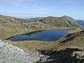 The source region on the Rainkarsee
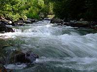 The Ache downstream
 The large weir of Brixentaler Ache near its confluence with the Windauer Ache in Hopfgarten.
High water
At the end of July 2006, bad weather in the entire Windau valley caused enormous damage. The Windauer Ache burst its banks and bridges, linings and sections of road were torn away.
The cost of repairing the damage - and the associated lining and regulation of the river - ran to some €860,000.