Brixentaler Ache
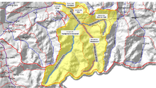 | |
| The diagram shows the tributaries coming from the south, the Kelchsauer Ache (blue highlights) and Windauer Ache (red highlights); the Brixentaler Ache (orange) rises as the Brixenbach (violet) in Brixen im Thale and empties in Wörgl into the Inn. The catchment area of the Brixentaler Ache is shaded yellow. | |
| Location | Kufstein and Kitzbühel districts, Tyrol, |
|---|---|
| Length | 28 km |
| Source | Einködl wind gap on the Gampenkogel in Brixen im Thale 47°24′09″N 12°15′21″E / 47.40250°N 12.25583°ECoordinates: 47°24′09″N 12°15′21″E / 47.40250°N 12.25583°E |
| Source height | 1,700 m (AA) |
| Mouth | near Wörgl into the River Inn 47°29′59″N 12°03′33″E / 47.49972°N 12.05917°E |
| Mouth height | 500 m (AA) |
| Descent | 1,200 m |
| Basin | Danube |
| Progression | Inn → Danube → Black Sea |
| Catchment | Windautal, Kelchsau (incl. Kurzem Grund and Langem Grund), Sölllandl and Brixental, as well as numerous smaller ditches and valleys, a total of some 330.3 km² |
| Left tributaries | Windauer Ache, Kelchsauer Ache |
| Small towns | Wörgl |
| Villages | Brixen im Thale, Westendorf, Hopfgarten im Brixental, Itter, Kirchbichl, Angath |
| Population in catchment | ca. 14,000 |
| Navigable | not navigable |
The Brixentaler Ache is a right tributary of the River Inn in Austria. It is located in the state of Tyrol and passes through the districts of Kitzbühel and Kufstein. The Brixentaler Ache ist one of the biggest tributaries of the Inn in the Tyrolean Unterland by catchment area (330.3 km²), but she is only 28 km long.
Course
The Brixentaler Ache rises as the Brixenbach in the territory of Brixen im Thale and flows westwards through the Brixental valley. Between Westendorf and Hopfgarten im Brixental (the main village in the valley) the valley floor narrows. Immediately after this bottleneck the Windauer Ache joins the Brixenbach from the south. From this confluence the Brixenbach is known as the Brixentaler Ache. After about a kilometre the larger Kelchsauer Ache (also from the south) joins the river. The ca. 26 km long Kelchsauer Ache drains the entire Kelchsau area.
Between Hopfgarten and Kirchbichl / Wörgl the Ache is again forced through a gorge, before it breaks out into the plains of the Inn valley. On leaving the gorge the Ache is impounded by a large weir and part of the water is diverted into a channel that leads to a small power station run by TIWAG. Below the weir the Luecher Bach enters the main stream from the direction of Söll to the north (Sölllandl). After having been fed by so much water from its big tributaries the Ache now dominates the landscape of the broad and densely settled Brixental valley. After the now around 16 metre wide Brixentaler Ache has flowed through Wörgl, it discharges from the south into the Inn.
The river's catchment area is relatively large, especially as a result of its tributaries, the Windauer Ache and Kelchsauer Ache, that covers about a third of the territory of Kitzbühel District.
-

The old weir on the Ache at the exit to the Itter gorge. It has since been replaced.
-

The Brixental and the Brixentaler Ache (foreground) where they join the Inn valley near Wörgl (background).
-
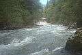
The Ache in the Itter Gorge.
-

The source region of the Brixentaler Ache in the Brixenbach valley.
-
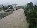
The Brixentaler Ache reached a critical 100-year high in 2005. (left: Kirchbichl, right: Wörgl)
-
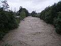
The Brixentaler Ache in Bruckhäusl at high water in summer 2008.
-
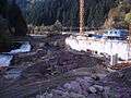
Construction of the new weir by Bruckhäusl Power Station at the exit of the Itter Gorge (end Oct 2010).
Water levels online
The water levels of the following gauges in the Ache's catchment area may be viewed at this page : ("Innzubringer" below)
- Brixenbach in Brixen im Thale
- Kelchsauer Ache in Hörbrunn (Hopfgarten im Brixental)
- Brixentaler Ache in Bruckhäusl (Kirchbichl and Wörgl)