Wimmenau
| Wimmenau Wìmmenau | ||
|---|---|---|
|
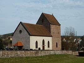
Église Saint-André (Church of Saint Andrew), erected in 1681. | ||
| ||
 Wimmenau | ||
|
Location within Grand Est region  Wimmenau | ||
| Coordinates: 48°54′47″N 7°25′26″E / 48.9131°N 7.4239°ECoordinates: 48°54′47″N 7°25′26″E / 48.9131°N 7.4239°E | ||
| Country | France | |
| Region | Grand Est | |
| Department | Bas-Rhin | |
| Arrondissement | Saverne | |
| Canton | Ingwiller | |
| Government | ||
| • Mayor (2014–2020) | Marc Ruch[1] | |
| Area1 | 20.76 km2 (8.02 sq mi) | |
| Population (2011)2 | 1,133 | |
| • Density | 55/km2 (140/sq mi) | |
| Time zone | CET (UTC+1) | |
| • Summer (DST) | CEST (UTC+2) | |
| INSEE/Postal code | 67535 / 67290 | |
| Elevation |
197–413 m (646–1,355 ft) (avg. 205 m or 673 ft) | |
| Website | http://www.wimmenau.fr | |
|
1 French Land Register data, which excludes lakes, ponds, glaciers > 1 km² (0.386 sq mi or 247 acres) and river estuaries. 2 Population without double counting: residents of multiple communes (e.g., students and military personnel) only counted once. | ||

Wimmenau is a commune in the Bas-Rhin department in Grand Est in north-eastern France.
History
Wimmenau is located at the crossroads of an ancient Celtic road from Haguenau to Sarre-Union and an ancient Roman road from Strasbourg to Sarrebruck. It was mentioned for the first time in 836 (as Wimmenawe). In 1365, during the Hundred Years War, a hill near the village was used by English soldiers to monitor the Sparsbach and Moder Valleys and named "Englishberg".[2]
The village was levelled during the Thirty Years War (1618–1648), except for the bell-tower of the Church of Saint Andrew, and was resettled by Swiss immigrants from the Bern area in the mid-seventeenth century.[3][2] Before the war, the town had 30 inhabitants. From 1637-1655, there was not a single bourgeois (middle-class inhabitant) in the town, which had 30 bourgeois before the war.[4][lower-alpha 1] As with most of the Alsace region, Wimmenau came under the rule of France in 1680.[2] The lack of farmland led to the emigration of many of the commune's inhabitants to the United States and Argentina during the nineteenth century.[2] Alsace became part of the German Empire through the Treaty of Frankfurt in 1871, but was returned to France by the Treaty of Versailles in 1919. The town came under German administration again during World War II until it was liberated by American troops on 5-6 December 1944.[2]
The town contains two national heritage sites (monuments historique). The Church of Saint Andrew (Église Saint-André), also known as the Protestant Church (Église protestante), was designated as a monument historique in 1995. Its bell-tower and chancel dates to the 12th century and was equipped with a ribbed vault in the 15th century. The church's nave—main building—was rebuilt after 1681 and expanded in 1878.[5] A house built in 1669 (with additions in 1718) by the Scherer[lower-alpha 2] brothers—Swiss immigrants—with an adjacent oil mill dating to 1837 was added in 1984.[6] The Scherer house, oil mill, and a few additional outbuildings form a complex which house historical artifacts related to rural life in the area.[3]
Geography
The commune lies along the Moder River; other waterways in the commune are the Rothbach and Rosteig Streams.[1] It is entirely within the Northern Vosges Regional Nature Park. It lies between 197 and 413 m elevation; the average elevation is 205 m.[7]
Climate
Wimmenau experiences an average of 1635 hours of sunshine a year (the average for France is 1900 hours).[7]
Demographics
Inhabitants are known as Wimmenauviens (males) or Wimmenauviennes (females).[1] The hamlet of Kohlhuette is divided between the communes of Wimmenau and Wingen-sur-Moder. The commune of Wimmenau's population was evenly spread in the 2010 census; there were 566 males (49.91% of the population) and 568 females (50.09% of the population). Between 1999-2010, the birth rate was 9.7% and the mortality rate was 7.4%.[8] According to the 2010 census, of people over 15, 27.9% were single (never married), 59.6% were married, 7.6% were widowed, and 4.9% were divorced.[9]
| 1793 | 1800 | 1806 | 1821 | 1831 | 1836 | 1841 | 1846 | 1851 | 1856 | 1861 | 1866 | 1872 | 1876 | 1881 | 1886 | 1891 |
|---|---|---|---|---|---|---|---|---|---|---|---|---|---|---|---|---|
| 292 | 302 | 350 | 445 | 433 | 500 | 524 | 568 | 590 | 562 | 576 | 537 | 567 | 550 | 573 | 593 | 588 |
| 1896 | 1901 | 1906 | 1911 | 1921 | 1926 | 1931 | 1936 | 1946 | 1954 | 1962 | 1968 | 1975 | 1982 | 1990 | 1999 | 2010 |
| 631 | 691 | 700 | 739 | 680 | 671 | 673 | 689 | 730 | 757 | 826 | 860 | 864 | 900 | 1012 | 1050 | 1134 |
| Sex | 0-14 | 15-29 | 30-44 | 45-59 | 60-74 | 75-89 | 90+ | Total |
|---|---|---|---|---|---|---|---|---|
| Males | 93 | 120 | 121 | 143 | 61 | 28 | 0 | 566 |
| Percentage (by sex) | 16.3 | 21.3 | 21.4 | 25.3 | 10.7 | 4.9 | 0.0 | 100.0 |
| Females | 102 | 94 | 126 | 125 | 74 | 45 | 2 | 568 |
| Percentage (by sex) | 18.0 | 16.5 | 22.2 | 22.1 | 13.0 | 7.9 | 0.4 | 100.0 |
Transport
Wimmenau lies along route D919—named Route Principale (Main Road) while passing through the town—connects the town of Wimmenau with Wingen-sur-Moder to the northwest and Ingwiller to the southeast. Route D12 connects the town of Wimmenau with the hamlet of Kohlhuette. Route D157 connects the town of Wimmenau with Reipertswiller.[11]
The town of Wimmenau lies along the Mommenheim-Sarreguemines rail line, which connects the cities of Strasbourg, France to Sarrebruck, Germany.[12] The rail line was built during German rule by the General Division of the Imperial Railways in Alsace-Lorraine; the section through Wimmenau opened 1 May 1895.[13] TER Alsace, a Train Express Régional operated by SNCF, operates on this line. Although there is a railroad station in Wimmenau, there is no rail service; TER Alsace serves Wimmenau with bus service connecting to rail service at Wingen-sur-Moder and Ingwiller.[14][15]
Notable residents
Politician Philippe Richert grew up in Wimmenau. He has served as senator for Bas-Rhin (1992–2010) and is the current president of the Alsace Regional Council (2010–present).[16]
Notes
- ↑ The commune's website says: "Before the Thirty Years War began in 1618, Wimmenau had 30 inhabitants...The last of the inhabitants sought refuge in Ingwiller and left the town uninhabited from 1637 to 1655." (French: "Lorsque la guerre de 30 Ans éclata en 1618, Wimmenau comptait 30 habitants...Les derniers habitants se réfugièrent à Ingwiller et laissèrent le village inoccupé de 1637 à 1655.")[2]
- ↑ Also spelled Sheer.
References
- 1 2 3 "Le village de Wimmenau". Annuaire Maire (in French). Retrieved 12 January 2015.
- 1 2 3 4 5 6 "Histoire, Lieux et Monuments". wimmenau.fr (in French). Commune of Wimmenau. Archived from the original on 7 May 2015. Retrieved 7 May 2015.
- 1 2 "Maison Suisse à Wimmenau et Conservatoire du patrimoine rural des Vosges du Nord". tourisme-alsace.com. Retrieved 10 January 2015.
- ↑ Reuss, Rodolphe (1897). Buillon, Émile, ed. L'Alsace au dix-septième siècle : au point de vue géographique, historique, administratif, économique, social, intellectuel et religieux. (Tome I) (in French). Paris: Bibliothèque de l'École des Hautes Études. p. 125. Retrieved 11 April 2015.
In Wimmenau, a village with 30 bourgeois before the war, there were none from 1637 to 1655. (French: A Wimmenau, village qui comptait 30 bourgeois avant la guerre, il n'y a plus, depuis 1637 à 1655, un seul habitant.)
- ↑ "Inventaire général du patrimoine culturel -". culture.gouv.fr (in French). French Ministry of Culture. Retrieved 10 January 2015.
- ↑ "Inventaire général du patrimoine culturel". culture.gouv.fr (in French). French Ministry of Culture. Retrieved 10 January 2015.
- 1 2 "Wimmenau". Vin Vigne (in French). Retrieved 12 January 2015.
- 1 2 3 "Chiffres clés Évolution et structure de la population - Commune de Wimmenau (67535)". Institut national de la statistique et des études économiques (INSEE) (in French). Retrieved 12 January 2015.
- ↑ "Chiffres clés Couples - Familles - Ménages". Institut national de la statistique et des études économiques (INSEE) (in French). Retrieved 12 January 2015.
- ↑ "Notice communal - Wimmenau". School for Advanced Studies in the Social Sciences/Cassini (in French). Retrieved 12 January 2015.
- ↑ "Plan Wimmenau". Mappy (in French). Retrieved 12 January 2015.
- ↑ "Voie 1 de la igne de Mommenheim à Sarreguemines". OpenStreetMap. Retrieved 12 January 2015.
- ↑ "GARE SNCF de " SARREGUEMINES "". http://christophe.lachenal.free.fr (in French). Retrieved 12 January 2015.
Le 01/05/1895, mise en service de la ligne de 69 km entre Mommenheim, Karlhausen et Sarralbe, par la Compagnie Alsace-Lorraine.
External link in|website=(help) - ↑ "Les lignes TER en Alsace" (PDF). Région Alsace (in French). Retrieved 15 January 2015.
- ↑ "Gare Wimmenau". SNCF (in French). Retrieved 15 January 2015.
- ↑ "Philippe Richert, celui qui sauva l'honneur de la majorité UMP aux régionales". LePoint.fr (in French). AFP. 26 March 2010. Retrieved 10 January 2015.
[He] grew up in a modest, working-class family in Wimmenau
External links
 Media related to Wimmenau at Wikimedia Commons
- Wimmenau.fr (French) - Official website of the commune government
 |
Goetzenbruck (Moselle) | Reipertswiller | | |
| Wingen-sur-Moder | |
Lichtenberg | ||
| ||||
| | ||||
| Erckartswiller | Sparsbach | Ingwiller |