Wangenbourg-Engenthal
| Wangenbourg-Engenthal | ||
|---|---|---|
 | ||
| ||
 Wangenbourg-Engenthal | ||
|
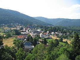
Location within Grand Est region  Wangenbourg-Engenthal | ||
| Coordinates: 48°38′N 7°18′E / 48.63°N 7.30°ECoordinates: 48°38′N 7°18′E / 48.63°N 7.30°E | ||
| Country | France | |
| Region | Grand Est | |
| Department | Bas-Rhin | |
| Arrondissement | Molsheim | |
| Canton | Saverne | |
| Government | ||
| • Mayor (2001–2008) | Antoine Walter | |
| Area1 | 31.52 km2 (12.17 sq mi) | |
| Population (2006)2 | 1,380 | |
| • Density | 44/km2 (110/sq mi) | |
| Time zone | CET (UTC+1) | |
| • Summer (DST) | CEST (UTC+2) | |
| INSEE/Postal code | 67122 / 67710 | |
| Elevation |
284–964 m (932–3,163 ft) (avg. 420 m or 1,380 ft) | |
|
1 French Land Register data, which excludes lakes, ponds, glaciers > 1 km² (0.386 sq mi or 247 acres) and river estuaries. 2 Population without double counting: residents of multiple communes (e.g., students and military personnel) only counted once. | ||

Wangenbourg-Engenthal (German: Wangenburg-Engenthal) is a commune in the Bas-Rhin department in Grand Est in north-eastern France.
The commune is not a single settlement, but rather an administrative unit comprising the following eight mountain hamlets:
- Engenthal-le-Bas
- Engenthal-le-Haut
- Freudeneck
- les Huttes
- Obersteigen
- Schneethal
- Windsbourg
- Wolfsthal
See also
References
| Wikimedia Commons has media related to Wangenbourg-Engenthal. |
This article is issued from Wikipedia - version of the 11/13/2016. The text is available under the Creative Commons Attribution/Share Alike but additional terms may apply for the media files.