Whitwarta, South Australia
| Whitwarta South Australia | |||||||||||||
|---|---|---|---|---|---|---|---|---|---|---|---|---|---|
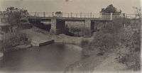
 Construction of the Whitwarta Bridge (c. 1914) The bridge was officially opened on 17 August 1914. As reported in the Advertiser, The Commissioner of Crown Lands (Hon. F. W. Young) opened the bridge.[1] | |||||||||||||
 Whitwarta | |||||||||||||
| Coordinates | 34°06′0″S 138°20′0″E / 34.10000°S 138.33333°ECoordinates: 34°06′0″S 138°20′0″E / 34.10000°S 138.33333°E | ||||||||||||
| Population | 276 (2011 census)[2] | ||||||||||||
| Established | 1870s | ||||||||||||
| Postcode(s) | 5461 | ||||||||||||
| LGA(s) | Wakefield Regional Council | ||||||||||||
| State electorate(s) | Goyder | ||||||||||||
| Federal Division(s) | Wakefield | ||||||||||||
| |||||||||||||
Whitwarta is a town in South Australia. The town is situated beside the Wakefield River (known as Undalya to the Indigenous people) about 100 km north of the state capital, Adelaide. The name Whitwarta means freshwater (distorted from Whitarter), a reference to the freshwater springs that exist along the pronounced bend in the river nearby.[3] The constant availability of freshwater along an otherwise dry river (the Rocks upstream of Balaklava is the next closest and permanent waterhole) meant that Whitwarta was a suitable place to establish a village. Approximately 20 people now live in the village.
Geographically, Whitwarta is situated on the plains, almost halfway between the Clare Valley and Skilly Hills to the East and the Southern Hummocks Ranges to the West. A series of salt lakes pepper the countryside to the West and North East of Whitwarta.
The old Whitwarta School (1879–1951)[4] still stands at the northern end of the village on Bowman St, as does the Post Office at the southern end. The church and Whitwarta Hotel[5] along the Kadina Road were damaged by floods during the 1900s, and were demolished as a consequence. The last flood occurred in September 2010 (the previous flood occurred in summer of 1998). A number of Eucalyptus camaldulensis sprouted on the flood plains and riparian zone shortly afterwards, some of which have been fenced-off by local farmers to avoid stock damage. A management plan for the River Wakefield was carried out in 2000, which included recommendations for the amelioration of water quality and flow at Whitwarta. Up until the late 1970s, it was common for the River Wakefield to flow every winter. Damming of the river upstream has impacted flows to the point that the River Wakefield now flows about once every five years. The trees around Whitwarta have suffered in recent years because of the rise of salinity in the soil. The National Trust of South Australia has listed a stand of Eucalyptus largiflorens (River Box) at Whitwarta on the significant tree registrar.[6] These trees, which are located approximately 500 metres (1,600 ft) north of the River Wakefield and about 600 metres (2,000 ft) west of the Halbury-Whitwarta intersection, are the only Eucalypts of their kind in the district. Local farmers say that these trees sprouted after a flood in the early-mid 1900s.
A gliding club and rifle club are both located on the outskirts of Whitwarta.
Whitwarta once had a cricket team and a tennis club.
Traditional occupants
According to the Manning Index of South Australian History, the "Nantuwwara (Nantawarra) tribe of some 25 to 30 once occupied the country from the River Wakefield, north to Whitwarta and west to the Hummock Range." The index indicates that the Nantuwarra name refers to the 'place where the kangaroo people live'.[7]
See the article by H.M. Cooper (1961) Trans. Roy. Soc. S. Aust. (1961), Vol. 34. for information about traditional campsites in the Wakefield River region.
Major floods

There are several accounts of major flooding of the Wakefield River at Whitwarta. The major floods recorded at Whitwarta occurred during the following years:
- 2010: Heavy rains throughout the catchment area of the Wakefield River caused major flooding at Whitwarata in early September. As in 1998, the water from the River flowed across the Whitarta to Balaklava Road (at the base of the Billabong Hill). It also flooded paddocks around the Whitwarta township, including the natural lagoon at the base of Whitwarta House. Water flowed across the Whitwarta to Kadina road. No damage to property or stock was recorded.
- 1998: The banks of the Wakefield River overflowed at Werocata and Whitwarta in winter. The water covered the Whitwarta to Balaklava Road and the Whitwarta to Kadina Road. The waters covered farmlands and remained for several months. Further rains in early summer 1998 caused the river to flood again. The old ruins of the Whitwarta Hotel were underwater, as was the depression behind the Whitwarta township. Locals caught European Carp in the waters that remained pooled in this depression. Such was the amount of water in the region, locals observed the appearance of brine shrimp in the waters of nearby salt lakes (especially the lakes near the northern lagoon of Diamond Lake).
- 1937: The Canberra Times on Sept 3, 1937 reported that: "A torrent of water ten chains wide, is sweeping across Whitwarta Road from Werochea [Werocata] station"[8]
Historic Whitwarta personalities and stories
Two German settlers from Hamley Bridge, Johannes Rudolph Ferdinand Heopner and Elise Moeller, who married on 6 June 1878, purchased property at Whitwarta upon marriage. They purchased property 44, 45 and eight other lots of the Hundred of Stow within the township of Whitwarta. They moved to Whitwarta in an attempt to set up a successful blacksmith business, and because they saw Whitwarta as a fit place to raise children. Johannes purchased land at Whitwarta with the hope that the town and surrounding districts would boom not only because of the availability of freshwater but because it was along one of the paths ("Gulf Road") that "Bullockies" used to cart copper from Burra to Port Wakefield. However, the boom period at Whitwarta did not last for long because of the creation of a railway at nearby Balaklava.
Irrespective of lean years of business, Jonny, as he was called, made a start in the once busy town. In 1878, with the help of his mate Conny Lange, a local stonemason from Balaklava, they built a 3-roomed cottage on lot 45 Hundred of Stow. The design and layout of the house was dictated by Jonny's financial situation at the time. The house was set back nearly 50 metres from Bowman Street (named after the pastoralist Edmund Bowman) so that his blacksmith shop (constructed in 1878) could sit almost directly beside the road.
The 1878 building consisted of a kitchen, bathroom and Whitwarta's first Post Office. They slept in the Post Office room. Materials used to construct the cottage included limestone, which was quarried from section 164 Hundred of Stow and red river sand. The sand was sourced from a bed in the River Wakefield behind the cemetery. Lime was made on the building site. Kilns were set up at most building sites in the district, as it saved on transporting materials from afar. Red bricks were used around windows and as quoins.
When Jonny had secured enough wealth from his blacksmith business, and because of a growing family, he decided to have another house built in front of the 1878 house. Now known as Whitwarta House, it was built in 1912 within a year by Jonny and Conny. Materials were sourced from the same locations as those used for the 1878 house.
According to local farmer Esmond Heopner, who lived in the house when he was younger, it was regarded as "a very modern house for its time." A modest and "quiet fellow citizen", the house reflected his standing in the community. The six-roomed house comprised a parlour (lounge) at the front, a passageway leading to the dining room and three bedrooms. A "boys room" was located at the rear. Es Heopner tells the story that this room allowed for the boys to quickly slip down to the river for a swim just before dinner time in the hope that their mother wouldn't notice their absence. Apparently their wet hair gave it away!
Drastic alterations occurred to Whitwarta House after Jonny's death in 1942. The 1878 building fell down shortly after, and the blacksmith shop was demolished due to limestone damage. Coins dating back to 1865 were found in-between the corners of the red brick, a tradition of builders of that time. Coins have recently been found behind the fireplaces in the house as well.
Jonny was a very religious man who belonged to the Lutheran congregation in Balaklava. It is said that he was one of the first to develop the stump-jump plough (a labour saving device to remove mallee tree stumps), for which he was awarded a medal for exhibiting it at the Port Wakefield Agricultural and Horticultural Society in 1885. Others, like Smith from Maitland, South Australia patented the invention. The stump-jump plough is now regarded as one of the most significant inventions that changed the face of the Australian countryside as it permitted land to be cleared at an unparalleled rate.
Summary of Whitwarta House

- 1878: small 3-room cottage built, consisting of bathroom, Post Office and Kitchen
- 1878: blacksmith shop built close to Bowman St
- 1912: Whitwarta house constructed in front of 3 bed. cottage
- 1977: Besser block addition as lean-to at rear of house
- 1978: Middle Gable about front verandah removed (due to corrosion)
- 1980: Interior alterations - two rooms combined
- 1989: Besser block addition extended
- 1992: Verandah added to rear of house. Posts are exact match to original. New posts were made at Nairne in the Adelaide Hills
Owners
- 1878-1942: Johannes and Elise Heopner. Sold at 400 pounds upon his passing.
- 1942-1959: Hennesey's
- 1959-1976: Hunter's
- 1976-1978: Anderson's
- 1978-2010: Heyes'
- 2010 present : Feenstra's
Trades and professions
In 1881, the follow trades and professions for Whitwarta were recorded in Wright's Australian and American commercial directory and gazetteer.[9]
- Storekeeper: R.T. Wilson
- Hotel: 'Whitwarta' David Pink
- Wheelwright: M. Koefner
Teachers at the Whitwarta School
Research by the University of South Australia indicates that the following teachers served at the now defunct Whitwarta School from 1879-1947:
| Year | Name |
|---|---|
| 1879–1883 | Howie, Edith M. |
| 1884 | Richardson, Jane |
| 1885 | Darby, Louisa Margaret |
| 1885–1886 | Tucker, Julia |
| 1887 | Armytage, Frances Gertrude |
| 1887 | Tucker, Julia |
| 1888 | Armytage, Frances Gertrude |
| 1889–1890 | Lucy, Mary Theresa |
| 1891 | Lowe, Edith Charlotte Lister |
| 1891 | Lucy, Mary Theresa |
| 1892 | Lowe, Edith Charlotte Lister |
| 1897–1898 | Tupper, Sarah Ann |
| 1899 | Kippin, Minnie |
| 1899–1903 | Tupper, Sarah Ann |
| 1904–1906 | Bowden, Blanche May |
| 1906–1907 | Clark, Evelyn Maude |
| 1907–1908 | Correll, Stella Daisy |
| 1908–1910 | McLean, Annie Isabel |
| 1946–1947 | Hooper, Maurice Desmond Thomas |
Source:[10]
Whitwarta residents involvement in WWI
Soon after World War I, a gathering at the school on Arbor Day, 19 August 1918, saw the unveiling of a roll of honor. It commemorated the ten old scholars who had served in the armed forces, including three who had been killed.[11] These included Driver Eric R. Lange, who died from gunshot wounds in action in France less than two years after he enlisted with the 9th Light Horse Regiment.[12] Another was Private Stanley Roy Angel who enlisted on 10 March 1917 and returned to Australia after the conclusion of the war, on 10 July 1919. He was also with the 9th Light Horse.[13]
Pioneer Celebration
On 3 December 2001 a number of local residents of Whitwarta gathered in front of Whitwarta House to celebrate the pioneers who shaped the township and the farms around it. A number of descendants of the original pioneers were present. A plaque was unveiled to commemorate the occasion. Esmond Hoepner of Whitwarta gave a plein-air presentation of the history and life of Whitwarta and its people.[14] A capsule was laid in concrete beneath the plaque. It is to be unveiled on 2 December 2101 by the Whitwarta residents of the time.
The plaque reads: This plaque is erected to commemorate the pioneers of this township before 1900. Whitwarta was named before 1850 and surveyed into 69 allotments in 1879. Apart from a number of private dwellings it had:
- Whitwarta Hotel 1886-1923
- Telephone added in 1924
- Wesleyan Church 1888-1920
- Government Wells 1874-1912
- Store and Post Office 1876-1967
- Blacksmith 1878-1903
- School 1879-1965
Names of some of the pioneers who made a valuable contribution in Whitwarta were
- J.J Angel, Farmer
- H.W Clark, Publican
- J.R.F Heopner, Blacksmith & Wheelwright
- J Hudson, Teamster
- E Router, Farmer
- R.T Wilson, Storekeeper & Clark
- C Belling, Farmer
- W.J Dunow, Caretaker
- R Hornhardt, Storekeeper
- D Pink, Publican
- J Watson, Builder
Whitwarta Cemetery
The cemetery is 1.5 km to the East of Whitwarta, surrounded by Aleppo Pine trees. Two of the people buried were passengers on the HMS Buffalo of the First Fleet of South Australia, John William Adams (died in 1893 aged 93) and Susanna Adams (died in 1891 aged 85). The plaque reads that these "Two pioneers of South Australia arrived with the first Governor in H.M.S Buffalo 1836 and was present at the proclamation of the colony, Dec 28, 1836."[15]
Whitwarta Bridge
A bridge over the Wakefield River was constructed in approximately 1884. However, by 1912, this bridge was decaying due to white ants and dry rot, and too narrow for the traffic using it.[16]
A new bridge was opened on 14 August 1914 by the Commissioner of Crown Lands, F. W. Young, accompanied by the other members of parliament for Wooroora, Oscar Duhst and David James and the chairman of the district council, Mr. F. McArdle.[17]
Diamond Lake
Diamond Lake, about 3 km west of the Whitwarta Village is a distinctive landscape feature of the region. It is an ephemeral salt lake. See location on Google Maps. The first Europeans to discover Diamond Lake, which they described as a 'dry lagoon', were the explorers John Hill and Thomas Burr, when passing through the Whitwarta district on 29 April 1840. A variety of wildfowl can be seen here when the Lake fills after winter rains, such as: Black Swans, Grey Teal, Chestnut Teal, Pacific Black Duck, Water Hens, and Plovers. Gypsum continues to be mined from the banks of the Lake. The Lake fills up from local rainfall-runoff, and fills from the northern lagoon first.
Historical and Contemporary Pictures of the township
 Horse and Cart near Whitwarta. Early 1900s. Image courtesy of Esmond Heopner.
References
- ↑ The Advertiser (Adel: 13 Aug 1914, p.8) http://nla.gov.au/nla.news-article6429211?searchTerm=whitwarta
- ↑ Australian Bureau of Statistics (31 October 2012). "Whitwarta". 2011 Census QuickStats. Retrieved 10 April 2013.
- ↑ Welwyn - Whyalla
- ↑ http://www.unisanet.unisa.edu.au/research/condon/teachers/teachers-list.asp?School=Whitwarta
- ↑ http://nla.gov.au/nla.cs-pa-HTTP%253A%252F%252F143.216.21.253%252FMPCIMG%252F56500%252FB56277.HTM
- ↑ http://www.nationaltrustsa.org.au/pdf/sig_tree_reg_2.pdf
- ↑ Nackara - Naracoorte
- ↑ "FLOODS IN SOUTH AUSTRALIA.". The Canberra Times. ACT: National Library of Australia. 3 September 1937. p. 1. Retrieved 1 February 2016.
- ↑ (Humphreys, W. (Ed) 1881. Wright's Australian and American commercial directory and gazetteer 1881. George Wright, NY. p. 135)
- ↑ Service histories of S.A. State Teachers
- ↑ "THE COUNTRY.". The Advertiser. Adelaide, SA: National Library of Australia. 24 August 1918. p. 6. Retrieved 4 February 2016.
- ↑ "THE WAR.". The Advertiser. Adelaide, SA: National Library of Australia. 28 June 1917. p. 6. Retrieved 4 February 2016.
- ↑ http://alh-research.tripod.com/Light_Horse/index.blog/1993261/9th-australian-light-horse-regiment-embarkation-roll-28th-reinforcement-commonwealth-group/
- ↑ A portion of the plaque presentation, recorded on video, can be viewed here:
- ↑ "Whitwarta Cemetery". Ancestry.com. Retrieved 2 February 2016.
- ↑ "THE COUNTRY.". The Advertiser (Adelaide, SA : 1889 - 1931). Adelaide, SA: National Library of Australia. 13 May 1912. p. 11. Retrieved 2 February 2016.
- ↑ "THE COUNTRY.". The Advertiser (Adelaide, SA : 1889 - 1931). Adelaide, SA: National Library of Australia. 17 August 1914. p. 13. Retrieved 2 February 2016.