White, Georgia
| White, Georgia | |
|---|---|
| City | |
|
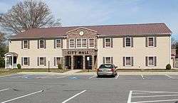
White City Hall | |
 Location in Bartow County and the state of Georgia | |
| Coordinates: 34°16′50″N 84°44′48″W / 34.28056°N 84.74667°WCoordinates: 34°16′50″N 84°44′48″W / 34.28056°N 84.74667°W | |
| Country | United States |
| State | Georgia |
| County | Bartow |
| Area | |
| • Total | 1.0 sq mi (2.5 km2) |
| • Land | 1.0 sq mi (2.5 km2) |
| • Water | 0 sq mi (0 km2) |
| Elevation | 860 ft (262 m) |
| Population (2010) | |
| • Total | 670 |
| • Density | 695/sq mi (268.2/km2) |
| Time zone | Eastern (EST) (UTC-5) |
| • Summer (DST) | EDT (UTC-4) |
| ZIP code | 30184 |
| Area code(s) | 770/678/470 |
| FIPS code | 13-82468[1] |
| GNIS feature ID | 0356633[2] |
| Website |
www |
White is a city in Bartow County, Georgia, United States. The population was 670 at the 2010 census.[3]
White is a stepping stone from rural areas of northwest Georgia to areas just south of White that are considered urban or urbanizing. White is located along U.S. Highway 411, 3 miles (5 km) north of Interstate 75. It is a bedroom community of Cartersville which is located 9 miles (14 km) to the south, but they are connected by a chain of homes and retail shops.
History
A post office called White has been in operation since 1890.[4] James Alexander White, the first postmaster, gave the city its name.[5]
In March 2016, the city's police chief, as well as its only full-time officer, were arrested on false imprisonment charges. The arrests left the city with no police department.[6]
Geography
White is located at 34°16′50″N 84°44′48″W / 34.28056°N 84.74667°W (34.280449, -84.746606).[7]
According to the United States Census Bureau, the city has a total area of 0.97 square miles (2.5 km2), all of it land.[3]
Demographics
| Historical population | |||
|---|---|---|---|
| Census | Pop. | %± | |
| 1920 | 319 | — | |
| 1930 | 544 | 70.5% | |
| 1940 | 474 | −12.9% | |
| 1950 | 454 | −4.2% | |
| 1960 | 439 | −3.3% | |
| 1970 | 462 | 5.2% | |
| 1980 | 501 | 8.4% | |
| 1990 | 542 | 8.2% | |
| 2000 | 693 | 27.9% | |
| 2010 | 670 | −3.3% | |
| Est. 2015 | 724 | [8] | 8.1% |
As of the census[1] of 2000, there were 693 people, 258 households, and 197 families residing in the city. The population density was 764.8 people per square mile (294.0/km²). There were 274 housing units at an average density of 302.4 per square mile (116.3/km²). The racial makeup of the city was 94.81% White, 2.89% African American, 0.29% Native American, 0.14% Asian, 0.87% from other races, and 1.01% from two or more races. Hispanic or Latino of any race were 2.60% of the population.
There were 258 households out of which 41.1% had children under the age of 18 living with them, 56.6% were married couples living together, 14.3% had a female householder with no husband present, and 23.6% were non-families. 20.9% of all households were made up of individuals and 9.3% had someone living alone who was 65 years of age or older. The average household size was 2.69 and the average family size was 3.04.
In the city the population was spread out with 31.0% under the age of 18, 8.9% from 18 to 24, 28.7% from 25 to 44, 19.2% from 45 to 64, and 12.1% who were 65 years of age or older. The median age was 32 years. For every 100 females there were 98.0 males. For every 100 females age 18 and over, there were 88.2 males.
The median income for a household in the city was $31,458, and the median income for a family was $36,250. Males had a median income of $30,500 versus $22,404 for females. The per capita income for the city was $14,665. About 13.8% of families and 15.5% of the population were below the poverty line, including 11.3% of those under age 18 and 17.4% of those age 65 or over.
References
- 1 2 "American FactFinder". United States Census Bureau. Retrieved 2008-01-31.
- ↑ "US Board on Geographic Names". United States Geological Survey. 2007-10-25. Retrieved 2008-01-31.
- 1 2 "Geographic Identifiers: 2010 Demographic Profile Data (G001): White city, Georgia". U.S. Census Bureau, American Factfinder. Retrieved November 1, 2013.
- ↑ "Bartow County". Jim Forte Postal History. Retrieved 23 April 2015.
- ↑ "Bartow County". Calhoun Times. September 1, 2004. p. 24. Retrieved 24 April 2015.
- ↑ Renzulli, Dante. GBI arrests police chief accused of bullying citizens into paying fines. cbs46.com. 30 March 2016. Retrieved 24 April 2016.
- ↑ "US Gazetteer files: 2010, 2000, and 1990". United States Census Bureau. 2011-02-12. Retrieved 2011-04-23.
- ↑ "Annual Estimates of the Resident Population for Incorporated Places: April 1, 2010 to July 1, 2015". Retrieved July 2, 2016.
- ↑ "Census of Population and Housing". Census.gov. Retrieved June 4, 2015.
External links
Municipalities and communities of Bartow County, Georgia, United States | ||
|---|---|---|
| Cities | 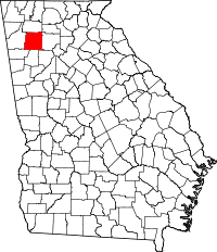 | |
| Town | ||
| Unincorporated communities | ||
| Ghost town | ||
| Footnotes | ‡This populated place also has portions in an adjacent county or counties | |