Emerson, Georgia
| Emerson, Georgia | |
|---|---|
| City | |
|
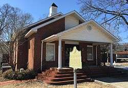
Emerson City Hall | |
 Location in Bartow County and the state of Georgia | |
| Coordinates: 34°7′52″N 84°45′10″W / 34.13111°N 84.75278°WCoordinates: 34°7′52″N 84°45′10″W / 34.13111°N 84.75278°W | |
| Country | United States |
| State | Georgia |
| County | Bartow |
| Incorporated (city) | January 1, 1889[1] |
| Area | |
| • Total | 7.32 sq mi (18.95 km2) |
| • Land | 7.30 sq mi (18.91 km2) |
| • Water | 0.02 sq mi (0.04 km2) |
| Elevation | 833 ft (254 m) |
| Population (2010) | |
| • Total | 1,470 |
| • Density | 201/sq mi (77.7/km2) |
| Time zone | Eastern (EST) (UTC-5) |
| • Summer (DST) | EDT (UTC-4) |
| ZIP code | 30137 |
| Area code(s) | 770/678/470 |
| FIPS code | 13-27344[2] |
| GNIS feature ID | 0331660[3] |
| Website |
emersoncityhall |
Emerson is a city in far southern Bartow County, Georgia, United States, on highways US-41, GA-293, and I-75. The population was 1,470 at the 2010 census,[4] an increase of 34% over the 2000 count of 1,092.
Emerson is a gateway to Red Top Mountain State Park, a Georgia state park, which is surrounded by Lake Allatoona.
History
Emerson was incorporated in 1889, and named for Joseph Emerson Brown, the 42nd Governor of Georgia.[5]
Geography
Emerson is located at 34°7′52″N 84°45′10″W / 34.13111°N 84.75278°W (34.131185, -84.752867).[6]
According to the United States Census Bureau, the city has a total area of 7.32 square miles (18.95 km2), of which 7.30 square miles (18.91 km2) is land and 0.015 square miles (0.04 km2), or 0.22%, is water.[4]
Demographics
| Historical population | |||
|---|---|---|---|
| Census | Pop. | %± | |
| 1880 | 200 | — | |
| 1890 | 437 | 118.5% | |
| 1900 | 581 | 33.0% | |
| 1910 | 659 | 13.4% | |
| 1920 | 632 | −4.1% | |
| 1930 | 657 | 4.0% | |
| 1940 | 1,497 | 127.9% | |
| 1950 | 1,527 | 2.0% | |
| 1960 | 1,320 | −13.6% | |
| 1970 | 1,326 | 0.5% | |
| 1980 | 1,507 | 13.7% | |
| 1990 | 1,178 | −21.8% | |
| 2000 | 1,584 | 34.5% | |
| 2010 | 1,619 | 2.2% | |
| Est. 2015 | 1,535 | [7] | −5.2% |
As of the census[2] of 2000, there were 1,092 people, 382 households, and 297 families residing in the city. The population density was 185.0 people per square mile (71.5/km²). There were 408 housing units at an average density of 69.1 per square mile (26.7/km²). The racial makeup of the city was 80.13% White, 17.03% African American, 0.46% Native American, 0.27% Asian, 0.55% from other races, and 1.56% from two or more races. Hispanic or Latino of any race were 2.38% of the population.
There were 382 households out of which 31.2% had children under the age of 18 living with them, 57.9% were married couples living together, 14.4% had a female householder with no husband present, and 22.0% were non-families. 19.1% of all households were made up of individuals and 8.9% had someone living alone who was 65 years of age or older. The average household size was 2.84 and the average family size was 3.21.
In the city the population was spread out with 26.6% under the age of 18, 8.1% from 18 to 24, 30.4% from 25 to 44, 23.5% from 45 to 64, and 11.4% who were 65 years of age or older. The median age was 35 years. For every 100 females there were 95.3 males. For every 100 females age 18 and over, there were 92.5 males.
The median income for a household in the city was $36,181, and the median income for a family was $41,429. Males had a median income of $29,250 versus $24,375 for females. The per capita income for the city was $16,270. About 12.3% of families and 16.4% of the population were below the poverty line, including 22.9% of those under age 18 and 17.9% of those age 65 or over.
References
- ↑ "Emerson". Georgia.gov. Retrieved 30 August 2014.
- 1 2 "American FactFinder". United States Census Bureau. Retrieved 2008-01-31.
- ↑ "US Board on Geographic Names". United States Geological Survey. 2007-10-25. Retrieved 2008-01-31.
- 1 2 "Geographic Identifiers: 2010 Demographic Profile Data (G001): Emerson city, Georgia". U.S. Census Bureau, American Factfinder. Retrieved November 1, 2013.
- ↑ "Bartow County". Calhoun Times. September 1, 2004. p. 19. Retrieved 24 April 2015.
- ↑ "US Gazetteer files: 2010, 2000, and 1990". United States Census Bureau. 2011-02-12. Retrieved 2011-04-23.
- ↑ "Annual Estimates of the Resident Population for Incorporated Places: April 1, 2010 to July 1, 2015". Retrieved July 2, 2016.
- ↑ "Census of Population and Housing". Census.gov. Retrieved June 4, 2015.
External links
Municipalities and communities of Bartow County, Georgia, United States | ||
|---|---|---|
| Cities | 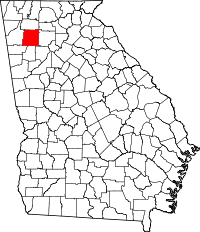 | |
| Town | ||
| Unincorporated communities | ||
| Ghost town | ||
| Footnotes | ‡This populated place also has portions in an adjacent county or counties | |