Wakarusa, Kansas
| Wakarusa, Kansas | |
|---|---|
| Census-designated place | |
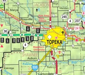 KDOT map of Shawnee County (legend) | |
 Wakarusa | |
| Coordinates: 38°53′09″N 95°41′45″W / 38.88583°N 95.69583°WCoordinates: 38°53′09″N 95°41′45″W / 38.88583°N 95.69583°W | |
| Country | United States |
| State | Kansas |
| County | Shawnee |
| Area[1] | |
| • Total | 4.999 sq mi (12.95 km2) |
| • Land | 4.965 sq mi (12.86 km2) |
| • Water | 0.034 sq mi (0.09 km2) |
| Elevation | 955 ft (291 m) |
| Population (2010 census)[2] | |
| • Total | 260 |
| • Density | 52/sq mi (20/km2) |
| Time zone | Central (CST) (UTC-6) |
| • Summer (DST) | CDT (UTC-5) |
| ZIP code | 66546 |
| Area code | 785 |
| GNIS ID | 479077 [3] |
Wakarusa is an unincorporated community and census-designated place in Shawnee County, Kansas, United States. Wakarusa is 11 miles (18 km) south of downtown Topeka. Wakarusa has a post office with ZIP code 66546. [4] As of the 2010 census, its population was 260.[2] Wakarusa is also the name of an unincorporated community in adjacent Douglas County, Kansas, 6.6 mi (10.6 km) southwest of downtown Lawrence and the name of the township that includes Lawrence, Kansas.
Wakarusa was founded in 1858.[5]
References
- ↑ "US Gazetteer files: 2010, 2000, and 1990". United States Census Bureau. 2011-02-12. Retrieved 2011-04-23.
- 1 2 "American FactFinder". United States Census Bureau. Retrieved 2011-05-14.
- ↑ "Wakarusa". Geographic Names Information System. United States Geological Survey.
- ↑ ZIP Code Lookup
- ↑ Blackmar, Frank Wilson (1912). Kansas: A Cyclopedia of State History, Volume 2. Standard Publishing Company. p. 854.
Municipalities and communities of Shawnee County, Kansas, United States | ||
|---|---|---|
| Cities | 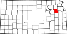 | |
| CDP | ||
| Unincorporated communities | ||
| Ghost town | ||
| Townships | ||
| Footnotes | ‡This populated place also has portions in an adjacent county or counties | |
This article is issued from Wikipedia - version of the 10/26/2016. The text is available under the Creative Commons Attribution/Share Alike but additional terms may apply for the media files.