Rossville, Kansas
| Rossville, Kansas | |
|---|---|
| City | |
|
Downtown Rossville (2006) | |
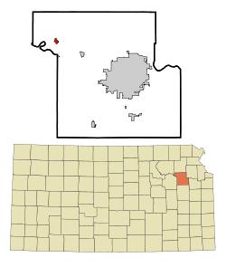 Location within Shawnee County and Kansas | |
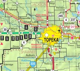 KDOT map of Shawnee County (legend) | |
| Coordinates: 39°8′12″N 95°57′5″W / 39.13667°N 95.95139°WCoordinates: 39°8′12″N 95°57′5″W / 39.13667°N 95.95139°W | |
| Country | United States |
| State | Kansas |
| County | Shawnee |
| Area[1] | |
| • Total | 0.61 sq mi (1.58 km2) |
| • Land | 0.61 sq mi (1.58 km2) |
| • Water | 0 sq mi (0 km2) |
| Elevation | 932 ft (284 m) |
| Population (2010)[2] | |
| • Total | 1,151 |
| • Estimate (2014)[3] | 1,139 |
| • Density | 1,900/sq mi (730/km2) |
| Time zone | CST (UTC-6) |
| • Summer (DST) | CDT (UTC-5) |
| ZIP code | 66533 |
| Area code | 785 |
| FIPS code | 20-61400 |
| GNIS ID | 0478436 [4] |
| Website | City Website |

Rossville is a city in Shawnee County, Kansas, United States. As of the 2010 census, the city population was 1,151.[5]
History
Rossville was founded in 1871.[6] It was named for William W. Ross, a Kansas reporter.[7]
Geography
Rossville is located at 39°8′12″N 95°57′5″W / 39.13667°N 95.95139°W (39.136559, -95.951255).[8] According to the United States Census Bureau, the city has a total area of 0.61 square miles (1.58 km2), all of it land.[1]
Climate
The climate in this area is characterized by hot, humid summers and generally mild to cool winters. According to the Köppen Climate Classification system, Rossville has a humid subtropical climate, abbreviated "Cfa" on climate maps.[9]
Demographics
| Historical population | |||
|---|---|---|---|
| Census | Pop. | %± | |
| 1880 | 323 | — | |
| 1890 | 420 | 30.0% | |
| 1900 | 555 | 32.1% | |
| 1910 | 672 | 21.1% | |
| 1920 | 664 | −1.2% | |
| 1930 | 701 | 5.6% | |
| 1940 | 601 | −14.3% | |
| 1950 | 577 | −4.0% | |
| 1960 | 797 | 38.1% | |
| 1970 | 934 | 17.2% | |
| 1980 | 1,045 | 11.9% | |
| 1990 | 1,052 | 0.7% | |
| 2000 | 1,014 | −3.6% | |
| 2010 | 1,151 | 13.5% | |
| Est. 2015 | 1,137 | [10] | −1.2% |
| U.S. Decennial Census[11] 2013 Estimate[12] | |||
Rossville is part of the Topeka, Kansas Metropolitan Statistical Area.
2010 census
As of the census[2] of 2010, there were 1,151 people, 413 households, and 293 families residing in the city. The population density was 1,886.9 inhabitants per square mile (728.5/km2). There were 448 housing units at an average density of 734.4 per square mile (283.6/km2). The racial makeup of the city was 92.3% White, 0.7% African American, 4.2% Native American, 0.2% Asian, 0.4% from other races, and 2.3% from two or more races. Hispanic or Latino of any race were 4.9% of the population.
There were 413 households of which 39.2% had children under the age of 18 living with them, 52.5% were married couples living together, 13.6% had a female householder with no husband present, 4.8% had a male householder with no wife present, and 29.1% were non-families. 24.9% of all households were made up of individuals and 13.1% had someone living alone who was 65 years of age or older. The average household size was 2.62 and the average family size was 3.15.
The median age in the city was 35.5 years. 30.1% of residents were under the age of 18; 6.4% were between the ages of 18 and 24; 25% were from 25 to 44; 20.3% were from 45 to 64; and 18.2% were 65 years of age or older. The gender makeup of the city was 46.1% male and 53.9% female.
2000 census
As of the census of 2000, there were 1,014 people, 383 households, and 279 families residing in the city. The population density was 2,075.2 people per square mile (799.0/km²). There were 411 housing units at an average density of 841.1 per square mile (323.9/km²). The racial makeup of the city was 94.48% White, 1.68% Native American, 0.59% Asian, 0.89% from other races, and 2.37% from two or more races. Hispanic or Latino of any race were 2.37% of the population.
There were 383 households out of which 37.6% had children under the age of 18 living with them, 59.0% were married couples living together, 10.7% had a female householder with no husband present, and 26.9% were non-families. 24.0% of all households were made up of individuals and 12.5% had someone living alone who was 65 years of age or older. The average household size was 2.52 and the average family size was 2.98.
In the city the population was spread out with 27.1% under the age of 18, 5.1% from 18 to 24, 28.3% from 25 to 44, 22.5% from 45 to 64, and 17.0% who were 65 years of age or older. The median age was 38 years. For every 100 females there were 88.5 males. For every 100 females age 18 and over, there were 80.7 males.
The median income for a household in the city was $44,118, and the median income for a family was $53,333. Males had a median income of $37,917 versus $25,347 for females. The per capita income for the city was $20,103. About 2.2% of families and 3.1% of the population were below the poverty line, including 2.4% of those under age 18 and 5.4% of those age 65 or over.
Education
Rossville is located in the Kaw Valley Unified School District 321. Kaw Valley coming from the area that the school district is in. Kaw Valley serves portions of the Tri-County area which includes Shawnee, Wabaunsee, Pottawatomie Counties. As well as portions of Jackson County. Kaw Valley serves the following cities: Emmett, Rossville, Saint Marys, and Delia. Kaw Valley
Sports
Rossville is home to a Summer Collegiate baseball team, the Rossville Rattlers. In 2013, the Rattlers won the National Baseball Congress 19 and Under World Series. The Rattlers play their games at Joe Campbell Memorial Stadium.[13] The Rattlers are members of the Mid-Plains League
References
- 1 2 "US Gazetteer files 2010". United States Census Bureau. Retrieved 2012-07-06.
- 1 2 "American FactFinder". United States Census Bureau. Retrieved 2012-07-06.
- ↑ "Annual Estimates of the Resident Population for Incorporated Places: April 1, 2010 to July 1, 2014". Retrieved June 4, 2015.
- ↑ "US Board on Geographic Names". United States Geological Survey. 2007-10-25. Retrieved 2008-01-31.
- ↑ "2010 City Population and Housing Occupancy Status". U.S. Census Bureau. Retrieved February 18, 2012.
- ↑ Biennial Report of the Board of Directors of the Kansas State Historical Society. Kansas State Historical Society. 1916. p. 293.
- ↑ Capace, Nancy (1 June 2000). Encyclopedia of Kansas. North American Book Dist LLC. p. 259. ISBN 978-0-403-09312-0.
- ↑ "US Gazetteer files: 2010, 2000, and 1990". United States Census Bureau. 2011-02-12. Retrieved 2011-04-23.
- ↑ Climate Summary for Rossville, Kansas
- ↑ "Annual Estimates of the Resident Population for Incorporated Places: April 1, 2010 to July 1, 2015". Retrieved July 2, 2016.
- ↑ "U.S. Decennial Census". Census.gov. Retrieved June 7, 2013.
- ↑ "Annual Estimates of the Resident Population: April 1, 2010 to July 1, 2013". Retrieved May 31, 2014.
- ↑ Rossville Rattlers
External links
| Wikimedia Commons has media related to Rossville, Kansas. |
- City
- Schools
- USD 321, local school district
- Historical
- Maps
- Rossville City Map, KDOT
Municipalities and communities of Shawnee County, Kansas, United States | ||
|---|---|---|
| Cities | 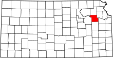 | |
| CDP | ||
| Unincorporated communities | ||
| Ghost town | ||
| Townships | ||
| Footnotes | ‡This populated place also has portions in an adjacent county or counties | |