Verona, New York
| Verona, New York | |
|---|---|
| Town | |
_highlighted.svg.png) Location in Oneida County and the state of New York. | |
| Coordinates: 43°9′0″N 75°37′16″W / 43.15000°N 75.62111°W | |
| Country | United States |
| State | New York |
| County | Oneida |
| Government | |
| • Type | Town Council |
| • Town Supervisor | Owen E. Waller (R) |
| • Town Council |
Members' List
|
| Area | |
| • Total | 69.7 sq mi (180.5 km2) |
| • Land | 69.3 sq mi (179.5 km2) |
| • Water | 0.4 sq mi (1.1 km2) |
| Elevation | 446 ft (136 m) |
| Population (2010) | |
| • Total | 6,293 |
| • Density | 90/sq mi (35/km2) |
| Time zone | Eastern (EST) (UTC-5) |
| • Summer (DST) | EDT (UTC-4) |
| ZIP code | 13478 |
| Area code(s) | 315 |
| FIPS code | 36-77178 |
| GNIS feature ID | 0979581 |
Verona is a town in southwestern Oneida County, New York, United States. The population was 6,293 at the 2010 census. The town was named after Verona, Italy.[1]
Verona is located 5km south of the City of Rome, NY.
History
Part of extensive territory of the Haudenosaunee or Iroquois League, the town was first settled by European Americans in 1792 after the American Revolutionary War. The Town of Verona was established from the Town of Westmoreland in 1802.
In 1993, the Oneida Nation purchased land in the town. On this site it built and opened a casino and bingo hall. By 1997, this facility was developed as a full-scale resort called Turning Stone Resort & Casino.
Geography
According to the United States Census Bureau, the town has a total area of 69.7 square miles (181 km2), of which, 69.3 square miles (179 km2) of it is land and 0.4 square miles (1.0 km2) of it (0.59%) is water.
The western part of the town borders Oneida Lake and Madison County, New York. The New York State Thruway and the Erie Canal cross the town.
Demographics
| Historical population | |||
|---|---|---|---|
| Census | Pop. | %± | |
| 1810 | 1,014 | — | |
| 1820 | 2,447 | 141.3% | |
| 1830 | 3,739 | 52.8% | |
| 1840 | 4,504 | 20.5% | |
| 1850 | 5,587 | 24.0% | |
| 1860 | 5,967 | 6.8% | |
| 1870 | 5,757 | −3.5% | |
| 1880 | 5,287 | −8.2% | |
| 1890 | 4,535 | −14.2% | |
| 1900 | 3,875 | −14.6% | |
| 1910 | 3,456 | −10.8% | |
| 1920 | 3,136 | −9.3% | |
| 1930 | 3,192 | 1.8% | |
| 1940 | 3,636 | 13.9% | |
| 1950 | 4,017 | 10.5% | |
| 1960 | 5,305 | 32.1% | |
| 1970 | 6,290 | 18.6% | |
| 1980 | 6,681 | 6.2% | |
| 1990 | 6,460 | −3.3% | |
| 2000 | 6,425 | −0.5% | |
| 2010 | 6,293 | −2.1% | |
| Est. 2014 | 6,274 | [2] | −0.3% |
As of the census[4] of 2000, there were 6,425 people, 2,399 households, and 1,813 families residing in the town. The population density was 92.7 people per square mile (35.8/km²). There were 2,665 housing units at an average density of 38.5 per square mile (14.9/km²). The racial makeup of the town was 97.71% White, 0.37% African American, 0.64% Native American, 0.37% Asian, 0.02% Pacific Islander, 0.05% from other races, and 0.84% from two or more races. Hispanic or Latino of any race were 0.47% of the population.
There were 2,399 households out of which 34.5% had children under the age of 18 living with them, 61.8% were married couples living together, 8.5% had a female householder with no husband present, and 24.4% were non-families. 19.0% of all households were made up of individuals and 8.2% had someone living alone who was 65 years of age or older. The average household size was 2.68 and the average family size was 3.05.
In the town the population was spread out with 26.6% under the age of 18, 6.6% from 18 to 24, 29.2% from 25 to 44, 25.2% from 45 to 64, and 12.4% who were 65 years of age or older. The median age was 38 years. For every 100 females there were 103.1 males. For every 100 females age 18 and over, there were 101.6 males.
The median income for a household in the town was $42,745, and the median income for a family was $47,951. Males had a median income of $32,328 versus $23,646 for females. The per capita income for the town was $18,017. About 3.8% of families and 5.7% of the population were below the poverty line, including 6.8% of those under age 18 and 3.0% of those age 65 or over.
Education
Verona is part of the Vernon-Verona-Sherrill Central School District. Students in grades Pre-K through 6 attend John D. George Elementary School, located on Main Street in the village of Verona. The main campus of Vernon-Verona-Sherrill High School and Middle School is located on New York State Route 31 in Verona, and serves students in grades 7-12.[5]
Communities and locations in Verona
- Agnes Corners – A hamlet southwest of Churchville.
- Blackmans Corners – A hamlet northeast of Verona.
- Cagwin Corners – A hamlet north of Verona.
- Churchville – A hamlet southwest of Verona Mills.
- Dumbarton – A hamlet on NY 46 north of State Bridge.
- Durhamville – A hamlet near the west town line.
- Dams Corner – A hamlet southwest of Verona.
- Fish Creek Station – A hamlet in the northwest part of the town near Verona Beach State Park.
- Goodrich Corners – A hamlet on the east town line.
- Higginsville – A hamlet on Route 46 north of Starks Landing. Noted in the 19th Century for Erie Canal boatbuilding.[6]
- Paradise Hill – A hamlet southeast of Starks Landing.
- Sconondoa – A hamlet on the town line in the southwest part of the town.
- Stacy Basin – A hamlet north of Higginsville on Route 46.
- Starks Landing – A hamlet on Route 46 north of Dumbarton.
- State Bridge – A hamlet north of Durhamville on Route 46.
- Sylvan Beach – A village on the western edge of the town.
- Verona – The hamlet of Verona was originally called "Hand's Village" and was the site of a health spa.
- Verona Beach – A hamlet on the shore of Oneida Lake, north of Verona Beach State Park.
- Verona Beach State Park – A state park on Oneida Lake.
- Verona Mills – A hamlet in the northeast corner of the town.
- Verona Station – A hamlet, located on NY 31, west of Verona.
References
- ↑ Chicago and North Western Railway Company (1908). A History of the Origin of the Place Names Connected with the Chicago & North Western and Chicago, St. Paul, Minneapolis & Omaha Railways. p. 134.
- ↑ "Annual Estimates of the Resident Population for Incorporated Places: April 1, 2010 to July 1, 2014". Retrieved June 4, 2015.
- ↑ "Census of Population and Housing". Census.gov. Archived from the original on May 11, 2015. Retrieved June 4, 2015.
- ↑ "American FactFinder". United States Census Bureau. Archived from the original on September 11, 2013. Retrieved 2008-01-31.
- ↑ http://www.vvsschools.org/
- ↑ Cmaylo, Dorothy. "Verona". Oneida County Historical Society.
Further reading
- Cmaylo, Dorothy M.; Beaver, Thomas A.; Regner, Kenneth A.; Hoffman, Sheila B. Verona. Arcadia. ISBN 978-0738572369. Volume in the well-known series from Arcadia that features history, old photographs and postcards.
External links
Coordinates: 43°08′17″N 75°34′15″W / 43.13806°N 75.57083°W
Municipalities and communities of Oneida County, New York, United States | ||
|---|---|---|
| Cities | 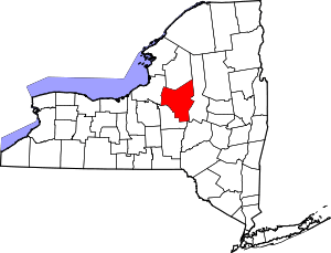 | |
| Towns | ||
| Villages | ||
| CDPs | ||
| Hamlets | ||