Vatili
| Vatili | |
|---|---|
 Vatili | |
| Coordinates: 35°08′02″N 33°39′19″E / 35.13389°N 33.65528°ECoordinates: 35°08′02″N 33°39′19″E / 35.13389°N 33.65528°E | |
| Country |
|
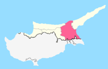
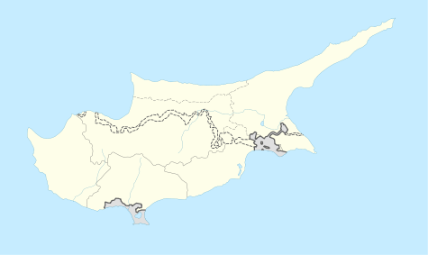
| • District | Famagusta District |
| Country (controlled by) |
|
| • District | Gazimağusa District |
| Population (2011)[1] | |
| • Total | 2,129 |
| • Municipality | 2,390 |
| Website | Turkish-Cypriot municipality |
Vatili (Greek: Βατυλή; Turkish: Vadili) is a village in the Famagusta District of Cyprus, near Lysi. De facto, it is under the control of Northern Cyprus.
During the British era, in the middle 1940s, a significant livestock station was built in Vatili by the authorities.[2] In 1973, Vatili had 3,161 inhabitants; of those, 72% were Greek Cypriots and 28% Turkish Cypriots. The Greek Cypriots of Vatili fled to the south of the island during the Turkish invasion of Cyprus. Today, the village is also inhabited by displaced Turkish Cypriots from the south and Turkish settlers.[3] As of 2011, its population was 2,129.
Culture, sports, and tourism
Turkish Cypriot Farmers of Vatili Sports Club was founded in 1943, and now in Cyprus Turkish Football Association (CTFA) K-PET 2nd League.[4]
The village has an association Vadili Sports for All Association.[5]
International relations
Turkish Cypriots organize International Folk Dance Fest each year.[6]
Twin towns – sister cities
Vatili is twinned with:
References
- ↑ "KKTC 2011 Nüfus ve Konut Sayımı" [TRNC 2011 Population and Housing Census] (PDF) (in Turkish). TRNC State Planning Organization. 6 August 2013.
- ↑ Christou, Eleni. "Κρατικός Κτηνοτροφικός Σταθμός (Βατιλή)". foodmuseum.cs.ucy.ac.cy (in Greek). Cyprus Food Virtual Museum. Retrieved 30 November 2015.
- ↑ "VATILI". Internal displacement in Cyprus. PRIO Cyprus Centre. Retrieved 19 November 2014.
- ↑ Northern Cyprus Association of Football Clubs
- ↑ Spor Kibris, 24 February 2015 Vadili Sports Association
- ↑ Haber KKTC, 12 September 2011 Vadili Int'l Folk Dance Fest
- ↑ OSMANİYE İLE KKTC’NİN VADİLİ BELEDİYESİ KARDEŞ OLUYOR', Osmaniye, retrieved 2013-10-20
| Lefkoşa District | |
|---|---|
| Gazimağusa District | |
| Girne District | |
| Güzelyurt District | |
| İskele District | |