Myrtou
| Myrtou | |
|---|---|
| Μύρτου (Greek) Çamlıbel (Turkish) | |
 Myrtou Location in Cyprus | |
| Coordinates: 35°18′32″N 33°4′26″E / 35.30889°N 33.07389°ECoordinates: 35°18′32″N 33°4′26″E / 35.30889°N 33.07389°E | |
| Country |
|
| • District | Kyrenia District |
| Country (controlled by) |
|
| • District | Girne District |
| Population (2011)[1] | |
| • Total | 4,321 |
| Time zone | EET (UTC+2) |
| • Summer (DST) | EEST (UTC+3) |
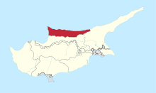
Myrtou (Greek: Μύρτου, Turkish: Çamlıbel) is a town in the Kyrenia District of Cyprus, north of the city of Morphou. It is under the de facto control of Northern Cyprus.
Name origin
There are several traditions as to how the village got its name. One of them says that the name comes from the plant Myrtos or Myrtia – myrtle. On the western side of the village there is a whole area full of myrtle as well as other plants and bushes.
This particular area is known as Mersinia. According to the writing of ancient writers myrtle was a plant dedicated to Goddess Aphrodite and God Apollo. There is a probability that in this area was a sanctuary dedicated to Apollo and even a small village with the name Myrtos. Myrtou area was inhabited prehistorically.
The present Turkish name Çamlıbel means "area with pines", and the village is currently on the edge of the Akdeniz National park with its pine forests and woodland walks.
Archaeological excavations in two areas of the village Stephanie and Pegades brought to light valuable findings. Oxford Ashmalian museum and a mission from Sydney Australia University carried out the excavations.
The finding proved the religious political and trading connection of Cyprus with other islands of Greece and especially Crete.
Location
Myrtou village is located southwest of Kyrenia at a height of 270 metres above sea level. It is on the south side of the Pentadaktylos mountains and because of its position was considered to be the administrative centre of the area before 1974.
From the village there is easy access to Nicosia through Asomatos and to Kyrenia through Panagra. It was also connected with Morphou through Diorios.
The village for many years had a limited number of people because the administrator of the monastery’s property was the Metropolis of Kyrenia. When the Metropolis decided to start dividing the land to smaller plots, the village begun to grow bigger and bigger. People could buy a plot of land build their house and stay in their village rather than to move to the towns.
The majority of the people living at Myrtou were farmers cultivating their fields or raising sheep, goats and cattle. Other were working at Nicosia or Xeros. Of course you could find carpenters, mechanics, butchers, storekeepers and so on. Later on Turkish Cypriots from Adrolikou, Paphos settled in Myrtou.
Since the Turkish invasion of Cyprus in 1974, the monastery of Saint Panteleimon remains empty with no monks or priest.
The Monastery of the Saint Panteleimon
Myrtou village owns its development to its monastery of the ST Panteleimon. The monastery played an important socio economic role in the development of the village and the area in general.
The story of the monastery's foundation has not been proven since there is no written proof. Therefore we turn to tradition and sayings of elder people. According to tradition two monks from Lapithos Dorotheos and Dositheos, left their monastery of ST Panteleimon at Agio Oros coming back to their island Cyprus to start a new monastery. With them they brought pieces of the holy bones of ST Panteleimon. The two monks tried to find a quiet place in the Lapithos and Karavas area but with no result. They moved on to an area today called AERAS, which was full of wild vegetation. Tired and thirsty as they were they sat down and prayed to their Saint to help them. As they were praying they saw water coming from the marble stones next to them. They drank water and thanked ST Panteleimon for his help. In the same place today you can find the Agiasma holy water of ST Panteleimon.
The two monks decided to start their monastery in this area. At first they built a small church and two rooms for themselves. An icon of Saint Panteleimon was placed in the church together with his holy bones for believers to visit. The monastery is said to have been founded around 1600 A.D.
Gradually the monastery grew bigger and bigger acguiring property. It became one of the richest monasteries of the island, offering jobs to the people of the villages around the area. The monastery had lots of fields for cultivation, floks of sheep, goats and cows. Later on the people that came to work the monastery's land brought their families together as well as believers that have been healed by the Saint and a new village was created around the monastery. This was the beginning of the village.
Saint Panteleimon is celebrated on 27 July each year. Many people from all over Cyprus were visiting the monastery to pay their respects to Saint Panteleimon. Before 1922, when Asia Minor was Greek, many worshipers were coming to Cyprus and to St Panteleimon monastery.
The area around here saw extensive fighting in 1974. Camlibel is at the high point of the lowest pass on the Kyrenia mountains. It can be protected by artillery from the mountains above Lapta, and once through the pass, there is a fairly clear run to Nicosia and on to Famagusta. Contemporary reports show that during the August cease fire, the Greek and Turkish armies were only 100 yards apart. Separated by a thin line of British soldiers who had orders not to open fire under any circumstances! The Daily Express carried the following report on 7 August 1974.[2]
References
- ↑ KKTC 2011 Nüfus ve Konut Sayımı [TRNC 2011 Population and Housing Census] (PDF), TRNC State Planning Organization, 6 August 2013
- ↑ http://www.whatson-northcyprus.com/interest/guzelyurt/panteleimon.htm
| Lefkoşa District | |
|---|---|
| Gazimağusa District | |
| Girne District | |
| Güzelyurt District | |
| İskele District | |