Union Township, Van Wert County, Ohio
| Union Township, Van Wert County, Ohio | |
|---|---|
| Township | |
|
Fields and a wind farm just east of Convoy | |
 Location of Union Township in Van Wert County | |
| Coordinates: 40°57′3″N 84°37′13″W / 40.95083°N 84.62028°WCoordinates: 40°57′3″N 84°37′13″W / 40.95083°N 84.62028°W | |
| Country | United States |
| State | Ohio |
| County | Van Wert |
| Area | |
| • Total | 36.5 sq mi (94.5 km2) |
| • Land | 36.5 sq mi (94.5 km2) |
| • Water | 0.0 sq mi (0.0 km2) |
| Elevation[1] | 751 ft (229 m) |
| Population (2000) | |
| • Total | 1,009 |
| • Density | 27.6/sq mi (10.7/km2) |
| Time zone | Eastern (EST) (UTC-5) |
| • Summer (DST) | EDT (UTC-4) |
| FIPS code | 39-78596[2] |
| GNIS feature ID | 1087095[1] |

Union Township is one of the twelve townships of Van Wert County, Ohio, United States. The 2000 census found 1,009 people in the township, 805 of whom lived in the unincorporated portions of the township.[3]
Geography
Located in the northern part of the county, it borders the following townships:
- Blue Creek Township, Paulding County - north
- Latty Township, Paulding County - northeast corner
- Hoaglin Township - east
- Ridge Township - southeast corner
- Pleasant Township - south
- Harrison Township - southwest corner
- Tully Township - west
- Benton Township, Paulding County - northwest corner
Part of the village of Scott is located in northwestern Union Township, along the border with Paulding County.
Name and history
It is one of twenty-seven Union Townships statewide.[4]
Government
The township is governed by a three-member board of trustees, who are elected in November of odd-numbered years to a four-year term beginning on the following January 1. Two are elected in the year after the presidential election and one is elected in the year before it. There is also an elected township fiscal officer,[5] who serves a four-year term beginning on April 1 of the year after the election, which is held in November of the year before the presidential election. Vacancies in the fiscal officership or on the board of trustees are filled by the remaining trustees.
References
- 1 2 "US Board on Geographic Names". United States Geological Survey. 2007-10-25. Retrieved 2008-01-31.
- ↑ "American FactFinder". United States Census Bureau. Archived from the original on September 11, 2013. Retrieved 2008-01-31.
- ↑ Van Wert County, Ohio — Population by Places Estimates Ohio State University, 2007. Accessed 15 May 2007.
- ↑ "Detailed map of Ohio" (PDF). United States Census Bureau. 2000. Retrieved 2007-02-16.
- ↑ §503.24, §505.01, and §507.01 of the Ohio Revised Code. Accessed 4/30/2009.
External links
Municipalities and communities of Van Wert County, Ohio, United States | ||
|---|---|---|
| Cities | 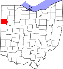 | |
| Villages | ||
| Townships | ||
| Unincorporated communities | ||
| Footnotes | ‡This populated place also has portions in an adjacent county or counties | |