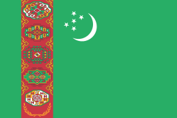
Turkmenistan
Coordinates: 40°N 60°E / 40°N 60°E
| Turkmenistan |
||||||
|---|---|---|---|---|---|---|
|
||||||
| Anthem: Garaşsyz Bitarap Türkmenistanyň Döwlet Gimni State Anthem of Independent, Neutral Turkmenistan  |
||||||
.svg.png) Location of Turkmenistan (red) |
||||||
| Capital and largest city | Ashgabat 37°58′N 58°20′E / 37.967°N 58.333°E | |||||
| Official languages | Turkmen[1] | |||||
| Inter-ethnic languages |
Russian | |||||
| Ethnic groups (2011) | ||||||
| Demonym | Turkmen | |||||
| Government | Unitary presidential republic | |||||
| • | President | Gurbanguly Berdimuhamedow | ||||
| • | Chairman of the Mejlis | Akja Nurberdiýewa | ||||
| Legislature | Mejlis | |||||
| Formation | ||||||
| • | Khanate of Khiva | 1511 | ||||
| • | Turkestan ASSR | 30 April 1918 | ||||
| • | Turkmen SSR | 13 May 1925 | ||||
| • | Declared state sovereignty | 22 August 1990 | ||||
| • | Declared independence from the Soviet Union | 27 October 1991 | ||||
| • | Recognized | 26 December 1991 | ||||
| • | Current constitution | 18 May 1992 | ||||
| Area | ||||||
| • | Total | 491,210 km2[2] (53rd) 188,456 sq mi |
||||
| • | Water (%) | 4.9 | ||||
| Population | ||||||
| • | 2014 estimate | 5,171,943[3] (117th) | ||||
| • | Density | 10.5/km2 (221st) 27.1/sq mi |
||||
| GDP (PPP) | 2016 estimate | |||||
| • | Total | $93.271 billion[4] | ||||
| • | Per capita | $17,072[4] | ||||
| GDP (nominal) | 2016 estimate | |||||
| • | Total | $35.398 billion[4] | ||||
| • | Per capita | $6,479[4] | ||||
| Gini (1998) | 40.8 medium |
|||||
| HDI (2014) | medium · 109th |
|||||
| Currency | Turkmen new manat (TMT) | |||||
| Time zone | TMT (UTC+5) | |||||
| Drives on the | right | |||||
| Calling code | +993 | |||||
| ISO 3166 code | TM | |||||
| Internet TLD | .tm | |||||
Turkmenistan (![]() i/tɜːrkˈmɛnᵻstæn/ or
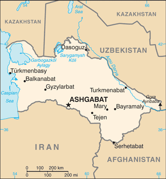
i/tɜːrkˈmɛnᵻstæn/ or ![]() i/tɜːrkmɛnᵻˈstɑːn/; Turkmen: Türkmenistan/Түркменистан/تۆركمهنيستآن, pronounced [tyɾkmeniˈθːaːn]); formerly known as Turkmenia[6] is a country in Central Asia, bordered by Kazakhstan to the northwest, Uzbekistan to the north and east, Afghanistan to the southeast, Iran to the south and southwest, and the Caspian Sea to the west.
i/tɜːrkmɛnᵻˈstɑːn/; Turkmen: Türkmenistan/Түркменистан/تۆركمهنيستآن, pronounced [tyɾkmeniˈθːaːn]); formerly known as Turkmenia[6] is a country in Central Asia, bordered by Kazakhstan to the northwest, Uzbekistan to the north and east, Afghanistan to the southeast, Iran to the south and southwest, and the Caspian Sea to the west.
Turkmenistan has been at the crossroads of civilizations for centuries. In medieval times, Merv was one of the great cities of the Islamic world and an important stop on the Silk Road, a caravan route used for trade with China until the mid-15th century. Annexed by the Russian Empire in 1881, Turkmenistan later figured prominently in the anti-Bolshevik movement in Central Asia. In 1924, Turkmenistan became a constituent republic of the Soviet Union, Turkmen Soviet Socialist Republic (Turkmen SSR); it became independent upon the dissolution of the Soviet Union in 1991.[7]
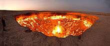
Turkmenistan possesses the world's fourth largest reserves of natural gas resources.[8] Most of the country is covered by the Karakum (Black Sand) Desert. Since 1993, citizens have received government-provided electricity, water and natural gas free of charge.[9]
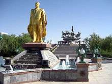
Turkmenistan was ruled by President for Life Saparmurat Niyazov until his death in 2006. Gurbanguly Berdimuhamedow was elected president in 2007. According to Human Rights Watch, "Turkmenistan remains one of the world’s most repressive countries. The country is virtually closed to independent scrutiny, media and religious freedoms are subject to draconian restrictions, and human rights defenders and other activists face the constant threat of government reprisal." President Berdimuhamedow promotes a personality cult in which he, his relatives, and associates enjoy unlimited power and total control over all aspects of public life.[10]
History
In the 8th century AD, Turkic-speaking Oghuz tribes moved from Mongolia into present-day Central Asia. Part of a powerful confederation of tribes, these Oghuz formed the ethnic basis of the modern Turkmen population.[11] In the 10th century, the name "Turkmen" was first applied to Oghuz groups that accepted Islam and began to occupy present-day Turkmenistan.[11] There they were under the dominion of the Seljuk Empire, which was composed of Oghuz groups living in present-day Iran and Turkmenistan.[11] Turkmen soldiers in the service of the empire played an important role in the spreading of Turkic culture when they migrated westward into present-day Azerbaijan and eastern Turkey.[11]
In the 12th century, Turkmen and other tribes overthrew the Seljuk Empire.[11] In the next century, the Mongols took over the more northern lands where the Turkmens had settled, scattering the Turkmens southward and contributing to the formation of new tribal groups.[11] The sixteenth and eighteenth centuries saw a series of splits and confederations among the nomadic Turkmen tribes, who remained staunchly independent and inspired fear in their neighbors.[11] By the 16th century, most of those tribes were under the nominal control of two sedentary Uzbek khanates, Khiva and Bukhoro.[11] Turkmen soldiers were an important element of the Uzbek militaries of this period.[11] In the 19th century, raids and rebellions by the Yomud Turkmen group resulted in that group's dispersal by the Uzbek rulers.[11] According to Paul R. Spickard, "Prior to the Russian conquest, the Turkmen were known and feared for their involvement in the Central Asian slave trade."[12][13]
Russian forces began occupying Turkmen territory late in the 19th century.[11] From their Caspian Sea base at Krasnovodsk (now Turkmenbashi), the Russians eventually overcame the Uzbek khanates.[11] In 1881, the last significant resistance in Turkmen territory was crushed at the Battle of Geok Tepe, and shortly thereafter Turkmenistan was annexed, together with adjoining Uzbek territory, into the Russian Empire.[11] In 1916 the Russian Empire's participation in World War I resonated in Turkmenistan, as an anticonscription revolt swept most of Russian Central Asia.[11] Although the Russian Revolution of 1917 had little direct impact, in the 1920s Turkmen forces joined Kazakhs, Kyrgyz, and Uzbeks in the so-called Basmachi Rebellion against the rule of the newly formed Soviet Union.[11] In 1924 the Turkmen Soviet Socialist Republic was formed from the tsarist province of Transcaspia.[11] By the late 1930s, Soviet reorganization of agriculture had destroyed what remained of the nomadic lifestyle in Turkmenistan, and Moscow controlled political life.[11] The Ashgabat earthquake of 1948 killed over 110,000 people,[14] amounting to two-thirds of the city's population.
During the next half-century, Turkmenistan played its designated economic role within the Soviet Union and remained outside the course of major world events.[11] Even the major liberalization movement that shook Russia in the late 1980s had little impact.[11] However, in 1990 the Supreme Soviet of Turkmenistan declared sovereignty as a nationalist response to perceived exploitation by Moscow.[11] Although Turkmenistan was ill-prepared for independence and communist leader Saparmurad Niyazov preferred to preserve the Soviet Union, in October 1991 the fragmentation of that entity forced him to call a national referendum that approved independence.[11] On December 26, 1991, the Soviet Union ceased to exist. Niyazov continued as Turkmenistan's chief of state, replacing communism with a unique brand of independent nationalism reinforced by a pervasive cult of personality.[11] A 1994 referendum and legislation in 1999 abolished further requirements for the president to stand for re-election (although in 1992 he completely dominated the only presidential election in which he ran, as he was the only candidate and no one else was allowed to run for the office), making him effectively president for life.[11] During his tenure, Niyazov conducted frequent purges of public officials and abolished organizations deemed threatening.[11] Throughout the post-Soviet era, Turkmenistan has taken a neutral position on almost all international issues.[11] Niyazov eschewed membership in regional organizations such as the Shanghai Cooperation Organisation, and in the late 1990s he maintained relations with the Taliban and its chief opponent in Afghanistan, the Northern Alliance.[11] He offered limited support to the military campaign against the Taliban following the 11 September 2001 attacks.[11] In 2002 an alleged assassination attempt against Niyazov led to a new wave of security restrictions, dismissals of government officials, and restrictions placed on the media.[11] Niyazov accused exiled former foreign minister Boris Shikhmuradov of having planned the attack.[11]
Between 2002 and 2004, serious tension arose between Turkmenistan and Uzbekistan because of bilateral disputes and Niyazov's implication that Uzbekistan had a role in the 2002 assassination attempt.[11] In 2004 a series of bilateral treaties restored friendly relations.[11] In the parliamentary elections of December 2004 and January 2005, only Niyazov's party was represented, and no international monitors participated.[11] In 2005 Niyazov exercised his dictatorial power by closing all hospitals outside Ashgabat and all rural libraries.[11] The year 2006 saw intensification of the trends of arbitrary policy changes, shuffling of top officials, diminishing economic output outside the oil and gas sector, and isolation from regional and world organizations.[11] China was among a very few nations to whom Turkmenistan made significant overtures.[11] The sudden death of Niyazov at the end of 2006 left a complete vacuum of power, as his cult of personality, compared to that of former president Kim Il-sung of North Korea, had precluded the naming of a successor.[11] Deputy Prime Minister Gurbanguly Berdimuhamedow, who was named interim head of government, won the special presidential election held in early February 2007.[11] He was re-elected in 2012 with 97% of the vote.[15]
Politics

After 69 years as part of the Soviet Union (including 67 years as a union republic), Turkmenistan declared its independence on 27 October 1991.
President for Life Saparmurat Niyazov, a former bureaucrat of the Communist Party of the Soviet Union, ruled Turkmenistan from 1985, when he became head of the Communist Party of the Turkmen SSR, until his death in 2006. He retained absolute control over the country after the dissolution of the Soviet Union. On 28 December 1999, Niyazov was declared President for Life of Turkmenistan by the Mejlis (parliament), which itself had taken office a week earlier in elections that included only candidates hand-picked by President Niyazov. No opposition candidates were allowed.
Since the December 2006 death of Niyazov, Turkmenistan's leadership has made tentative moves to open up the country. His successor, President Gurbanguly Berdimuhamedow, repealed some of Niyazov's most idiosyncratic policies, including banning opera and the circus for being "insufficiently Turkmen". In education, Berdimuhamedow's government increased basic education to ten years from nine years, and higher education was extended from four years to five. It also increased contacts with the West, which is eager for access to the country's natural gas riches.
The politics of Turkmenistan take place in the framework of a presidential republic, with the President both head of state and head of government. Under Niyazov, Turkmenistan had a one-party system; however, in September 2008, the People's Council unanimously passed a resolution adopting a new Constitution. The latter resulted in the abolition of the Council and a significant increase in the size of Parliament in December 2008 and also permits the formation of multiple political parties.
The former Communist Party, now known as the Democratic Party of Turkmenistan, is the dominant party. The second party, the Party of Industrialists and Entrepreneurs was established in August 2012. Political gatherings are illegal unless government sanctioned. In 2013 the first multi-party Parliamentary Elections were held in Turkmenistan. Turkmenistan was a one-party state from 1991 to 2012; however, the 2013 elections were widely seen as mere window dressing.[16] In practice, all parties in parliament operate jointly under the direction of the DPT. There are no true opposition parties in the Turkmen parliament.
Foreign relations
Turkmenistan's declaration of "permanent neutrality" was formally recognized by the United Nations in 1995.[17] Former President Saparmurat Niyazov stated that the neutrality would prevent Turkmenistan from participating in multi-national defense organizations, but allows military assistance. Its neutral foreign policy has an important place in the country's constitution. Turkmenistan has diplomatic relations with 132 countries.[18]
Human rights
Turkmenistan has been widely criticised for human rights abuses and has imposed severe restrictions on foreign travel for its citizens.[19] Discrimination against the country's ethnic minorities remains in practice. Universities have been encouraged to reject applicants with non-Turkmen surnames, especially ethnic Russians.[20] It is forbidden to teach the customs and language of the Baloch, an ethnic minority. The same happens to Uzbeks, though the Uzbek language was formerly taught in some national schools.[21]
According to Reporters Without Borders' 2014 World Press Freedom Index, Turkmenistan had the 3rd worst press freedom conditions in the world (178/180 countries), just before North Korea and Eritrea.[22] It is considered to be one of the "10 Most Censored Countries". Each broadcast under Niyazov began with a pledge that the broadcaster's tongue will shrivel if he slanders the country, flag, or president.[23]
Religious minorities are discriminated against for conscientious objection and practicing their religion by imprisonment, preventing foreign travel, confiscating copies of Christian literature or defamation.[24][25][26]
Restrictions on free and open communication
Despite the launch of Turkmenistan's first communication satellite—TurkmenSat 1—in April 2015, the Turkmen government banned all satellite dishes in Turkmenistan the same month. The statement issued by the government indicated that all existing satellite dishes would have to be removed or destroyed—despite the communications receiving antennas having been legally installed since 1995—in an effort by the government to fully block access of the population to many "hundreds of independent international media outlets which are currently accessible in the country only through satellite dishes, including all leading international news channels in different languages. The main target of this campaign is Radio Azatlyk, the Turkmen-language service of Radio Free Europe/Radio Liberty. It is the only independent source of information about Turkmenistan and the world in the Turkmen language and is widely listened to in the country."[27]
Administrative divisions
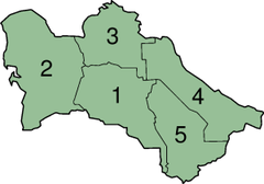

Turkmenistan is divided into five provinces or welayatlar (singular welayat) and one capital city district. The provinces are subdivided into districts (etraplar, sing. etrap), which may be either counties or cities. According to the Constitution of Turkmenistan (Article 16 in the 2008 Constitution, Article 47 in the 1992 Constitution), some cities may have the status of welaýat (province) or etrap (district).
| Division | ISO 3166-2 | Capital city | Area[28] | Pop (2005)[28] | Key |
|---|---|---|---|---|---|
| Ashgabat City | TM-S | Ashgabat | 470 km2 (180 sq mi) | 871,500 | |
| Ahal Province | TM-A | Anau | 97,160 km2 (37,510 sq mi) | 939,700 | 1 |
| Balkan Province | TM-B | Balkanabat | 139,270 km2 (53,770 sq mi) | 553,500 | 2 |
| Daşoguz Province | TM-D | Daşoguz | 73,430 km2 (28,350 sq mi) | 1,370,400 | 3 |
| Lebap Province | TM-L | Türkmenabat | 93,730 km2 (36,190 sq mi) | 1,334,500 | 4 |
| Mary Province | TM-M | Mary | 87,150 km2 (33,650 sq mi) | 1,480,400 | 5 |
Climate
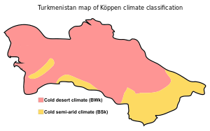
The Karakum Desert is one of the driest deserts in the world; some places have an average annual precipitation of only 12 mm (0.47 in). The highest temperature recorded in Ashgabat is 48.0 °C (118.4 °F) and Kerki, an extreme inland city located on the banks of the Amu Darya river, recorded 51.7 °C (125.1 °F) in July 1983, although this value is unofficial. 50.1 °C (122 °F) is the highest temperature recorded at Repetek Reserve, recognized as the highest temperature ever recorded in the whole former Soviet Union.
Geography
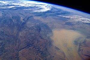
At 488,100 km2 (188,500 sq mi), Turkmenistan is the world's 52nd-largest country. It is slightly smaller than Spain and somewhat larger than the US state of California. It lies between latitudes 35° and 43° N, and longitudes 52° and 67° E. Over 80% of the country is covered by the Karakum Desert. The center of the country is dominated by the Turan Depression and the Karakum Desert. The Kopet Dag Range, along the southwestern border, reaches 2,912 metres (9,554 feet) at Kuh-e Rizeh (Mount Rizeh).[29]
The Great Balkhan Range in the west of the country (Balkan Province) and the Köýtendag Range on the southeastern border with Uzbekistan (Lebap Province) are the only other significant elevations. The Great Balkhan Range rises to 1,880 metres (6,170 ft) at Mount Arlan[30] and the highest summit in Turkmenistan is Ayrybaba in the Kugitangtau Range – 3,137 metres (10,292 ft).[31] The Kopet Dag mountain range forms most of the border between Turkmenistan and Iran. Rivers include the Amu Darya, the Murghab, and the Tejen.
The climate is mostly arid subtropical desert, with little rainfall. Winters are mild and dry, with most precipitation falling between January and May. The area of the country with the heaviest precipitation is the Kopet Dag Range.
The Turkmen shore along the Caspian Sea is 1,748 kilometres (1,086 mi) long. The Caspian Sea is entirely landlocked, with no natural access to the ocean, although the Volga–Don Canal allows shipping access to and from the Black Sea.
The major cities include Aşgabat, Türkmenbaşy (formerly Krasnovodsk) and Daşoguz.
Economy
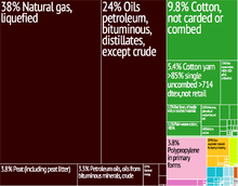
The country possesses the world's fourth-largest reserves of natural gas and substantial oil resources.[32] Turkmenistan has taken a cautious approach to economic reform, hoping to use gas and cotton sales to sustain its economy. In 2004, the unemployment rate was estimated to be 60%.[33]
Between 1998 and 2002, Turkmenistan suffered from the continued lack of adequate export routes for natural gas and from obligations on extensive short-term external debt. At the same time, however, the value of total exports has risen sharply because of increases in international oil and gas prices. Economic prospects in the near future are discouraging because of widespread internal poverty and the burden of foreign debt.
President Niyazov spent much of the country's revenue on extensively renovating cities, Ashgabat in particular. Corruption watchdogs voiced particular concern over the management of Turkmenistan's currency reserves, most of which are held in off-budget funds such as the Foreign Exchange Reserve Fund in the Deutsche Bank in Frankfurt, according to a report released in April 2006 by London-based non-governmental organization Global Witness.
According to the decree of the Peoples' Council of 14 August 2003,[34] electricity, natural gas, water and salt will be subsidized for citizens up to 2030. In addition car drivers were entitled to 120 litres of free petrol a month until 1/7/14. Drivers of buses, lorries and tractors could get 200 litres of fuel and motorcyclists and scooter riders 40 litres free. On 5 September 2006, after Turkmenistan threatened to cut off supplies, Russia agreed to raise the price it pays for Turkmen natural gas from $65 to $100 per 1,000 cubic meters. Two-thirds of Turkmen gas goes through the Russian state-owned Gazprom.[35]
Natural gas and export routes
As of May 2011, the Galkynysh gas field has the second-largest volume of gas in the world, after the South Pars field in the Persian Gulf. Reserves at the Galkynysh gas field are estimated at around 21.2 trillion cubic metres.[36] The Turkmenistan Natural Gas Company (Türkmengaz), under the auspices of the Ministry of Oil and Gas, controls gas extraction in the country. Gas production is the most dynamic and promising sector of the national economy. In 2010 Ashgabat started a policy of diversifying export routes for its raw materials.[37] China is set to become the largest buyer of gas from Turkmenistan over the coming years as a pipeline linking the two countries, through Uzbekistan and Kazakhstan, reaches full capacity.[38] In addition to supplying Russia, China and Iran, Ashgabat took concrete measures to accelerate progress in the construction of the Turkmenistan-Afghanistan-Pakistan and India pipeline (TAPI). Turkmenistan has previously estimated the cost of the project at $3.3 billion. On 21 May 2010, president Gurbanguly Berdimuhamedow unexpectedly signed a decree stating that companies from Turkmenistan will build an internal East-West gas pipeline allowing the transfer of gas from the biggest deposits in Turkmenistan (Dowlatabad and Yoloten) to the Caspian coast. The East-West pipeline is planned to be around 1,000 km long and have a carrying capacity of 30 bn m³ annually, at a cost of between one and one and a half billion US dollars.[37]
Oil
Most of Turkmenistan's oil is extracted by the Turkmenistan State Company (Concern) Türkmennebit from fields at Koturdepe, Balkanabat, and Cheleken near the Caspian Sea, which have a combined estimated reserve of 700 million tons. The oil extraction industry started with the exploitation of the fields in Cheleken in 1909 (by Branobel) and in Balkanabat in the 1930s. Production leaped ahead with the discovery of the Kumdag field in 1948 and the Koturdepe field in 1959. A big part of the oil produced in Turkmenistan is refined in Turkmenbashy and Seidi refineries. Also, oil is exported by tankers through the Caspian Sea to Europe via canals.[39]
Energy
Turkmenistan is a net exporter of electrical power to Central Asian republics and southern neighbors. The most important generating installations are the Hindukush Hydroelectric Station, which has a rated capacity of 350 megawatts, and the Mary Thermoelectric Power Station, which has a rated capacity of 1,370 megawatts. In 1992, electrical power production totaled 14.9 billion kilowatt-hours.[40]
Agriculture
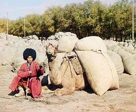
In Turkmenistan, most of irrigated land is planted with cotton, making the country the world's ninth-largest cotton producer.[41]
During the 2011 season, Turkmenistan produced around 1.1 million tons of raw cotton, mainly from Mary, Balkan, Akhal, Lebap and Dashoguz provinces. In 2012, around 7,000 tractors, 5,000 cotton cultivators, 2,200 sowing machines and other machinery, mainly procured from Belarus and the US, are being used. The country traditionally exports raw cotton to Russia, Iran, South Korea, Britain, China, Indonesia, Turkey, Ukraine, Singapore and the Baltic nations.[42]
Tourism
The tourism industry has been growing rapidly in recent years, especially medical tourism. This is primarily due to the creation of the Avaza tourist zone on the Caspian Sea.[43] Every traveler must obtain a visa before entering Turkmenistan. To obtain a tourist visa, citizens of most countries need a visa support local travel agency. For tourists visiting Turkmenistan, organized tours with a visit to historical sites Daşoguz, Konye-Urgench, Nisa, Merv, Mary, beach tours to Avaza and medical tours and holidays in Mollakara, Yylly suw, Archman.
Demographics
Most of Turkmenistan's citizens are ethnic Turkmens with sizeable minorities of Uzbeks and Russians. Smaller minorities include Kazakhs, Tatars, Ukrainians, Kurds (native to Kopet Dagh mountains), Armenians, Azeris, Balochs and Pashtuns. The percentage of ethnic Russians in Turkmenistan dropped from 18.6% in 1939 to 9.5% in 1989. In 2012 it was confirmed that the population of Turkmenistan decreased due to some specific factors and is less than the previously estimated 5 million.[44]
The CIA World Factbook gives the ethnic composition of Turkmenistan as 85% Turkmen, 5% Uzbek, 4% Russian and 6% other (2003 estimates).[33] According to data announced in Ashgabat in February 2001, 91% of the population are Turkmen, 3% are Uzbeks and 2% are Russians. Between 1989 and 2001 the number of Turkmen in Turkmenistan doubled (from 2.5 to 4.9 million), while the number of Russians dropped by two-thirds (from 334,000 to slightly over 100,000).[45]
Largest cities
The largest cities in Turkmenistan are
- Ashgabat (pop. 727,700, 2012)
- Türkmenabat (pop. 234,817)?
- Daşoguz (pop. 166,500, 2004)
- Mary (pop. 114,680)?
- Balkanabat (pop. 120,800, 2011)
- Bayramaly (pop. 88,486, 2009)
- Türkmenbaşy (pop. 73,000, 2010)
- Tejen (pop. 67,294)
- Abadan (pop.39,481)
- Yolöten (pop. 37,705)
Language
Turkmen is the official language of Turkmenistan (per the 1992 Constitution), although Russian still is widely spoken in cities as a "language of inter-ethnic communication". Turkmen is spoken by 72% of the population, Russian 12%, Uzbek 9%,[33] and other languages 7%. (Russian (349,000), Uzbek (317,000), Kazakh (88,000), Tatar (40,400), Ukrainian (37,118), Azerbaijani (33,000), Armenian (32,000), Northern Kurdish (20,000), Lezgian (10,400), Persian (8,000), Belarusian (5,290), Erzya (3,490), Korean (3,490), Bashkir (2,610), Karakalpak (2,540), Ossetic (1,890), Dargwa (1,600), Lak (1,590), Tajik (1,280), Georgian (1,050), Lithuanian (224), Tabasaran (180), Dungan).[46]
Religion
.jpg)
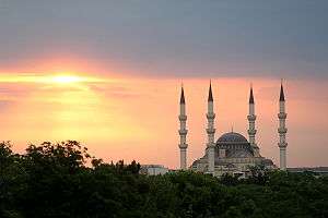
According to the CIA World Factbook, Muslims constitute 89% of the population while 9% of the population are followers of the Eastern Orthodox Church and the remaining 2% religion is reported as non-religious.[33] However, according to a 2009 Pew Research Center report, 93.1% of Turkmenistan's population is Muslim.[48]
The first migrants were sent as missionaries and often were adopted as patriarchs of particular clans or tribal groups, thereby becoming their "founders." Reformulation of communal identity around such figures accounts for one of the highly localized developments of Islamic practice in Turkmenistan.
In the Soviet era, all religious beliefs were attacked by the communist authorities as superstition and "vestiges of the past." Most religious schooling and religious observance were banned, and the vast majority of mosques were closed. However, since 1990, efforts have been made to regain some of the cultural heritage lost under Soviet rule.
Former president Saparmurat Niyazov ordered that basic Islamic principles be taught in public schools. More religious institutions, including religious schools and mosques, have appeared, many with the support of Saudi Arabia, Kuwait, and Turkey. Religious classes are held in both schools and mosques, with instruction in Arabic language, the Qur'an and the hadith, and history of Islam.[49]
President Niyazov wrote his own religious text, published in separate volumes in 2001 and 2004, entitled the Ruhnama. The Turkmenbashi regime required that the book, which formed the basis of the educational system in Turkmenistan, be given equal status with the Quran (mosques were required to display the two books side by side). The book was heavily promoted as part of the former president's personality cult, and knowledge of the Ruhnama is required even for obtaining a driver's license.[50]
The history of Bahá'í Faith in Turkmenistan is as old as the religion itself, and Bahá'í communities still exist today.[51] The first Bahá'í House of Worship was built in Ashgabat at the beginning of the twentieth century. It was seized by the Soviets in the 1920s and converted to an art gallery. It was heavily damaged in the earthquake of 1948 and later demolished. The site was converted to a public park.[52]
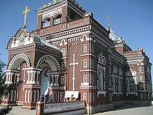
There are small communities of the following denominations: the Armenian Apostolic Church, the Roman Catholic Church, Pentecostal Christians, the Protestant Word of Life Church, the Greater Grace World Outreach Church, the New Apostolic Church, Jehovah's Witnesses, Jews, and several unaffiliated, nondenominational evangelical Christian groups. In addition, there are small communities of Baha'is, Baptists, Seventh-day Adventists, and Hare Krishnas.[53]
Culture
_(14780627715).jpg) Turkmen carpet (1922).
Turkmen carpet (1922)._(14576861108).jpg) Turkmen carpet (1920).
Turkmen carpet (1920).
- Akhal-Teke horse
- Yomut carpet
- Turkmen carpet
- Islam in Turkmenistan
- Merv
- Music of Turkmenistan
- Turkmen cuisine
Heritage
| Image | Name | Location | Notes | Date added | Type |
|---|---|---|---|---|---|
 |
Ancient Merv | Baýramaly, Mary Province | a major oasis-city in Central Asia, on the historical Silk Road | 1995 | Cultural[54] |
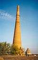 |
Köneürgenç | Köneürgenç | unexcavated ruins of the 12th-century capital of Khwarezm | 2005 | Cultural[55] |
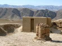 |
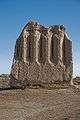
Parthian Fortresses of Nisa | Bagyr, Ahal Province | one of the first capitals of the Parthians | 2007 | Cultural[56] |
Mass media
There are a number of newspapers and monthly magazines published in Turkmenistan. Turkmenistan currently broadcasts 7 national TV channels through satellite. They are Altyn asyr, Yashlyk, Miras, Turkmenistan (in 7 languages), Turkmen owazy, Turkmen sporty and Ashgabat. There are no commercial or private TV stations. Articles published by the state-controlled newspapers are heavily censored and written to glorify the state and its leader.
|
|
Internet services are the least developed in Central Asia. Access to internet services are provided by the government's ISP company "Turkmentelekom". As of 31 December 2011, it was estimated that there were 252,741 internet users in Turkmenistan or roughly 5% of total population.[57][58]
Education
.jpg)
Education is universal and mandatory through the secondary level, the total duration of which was earlier reduced from 10 to 9 years; with the new President it has been decreed that from the 2007–2008 school year on, mandatory education will be for 10 years. From 2013 secondary general education in Turkmenistan is a three-stage secondary schools for 12 years according to the following steps: Elementary school (grades 1–3), High School – the first cycle of secondary education with duration of 5 years (4–8 classes), Secondary school – the second cycle of secondary education, shall be made within 4 years (9–12 classes).[59][60]
Architecture
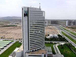
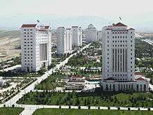
The task for modern Turkmen architecture is diverse application of modern aesthetics, the search for an architect's own artistic style and inclusion of the existing historico-cultural environment. Most buildings are faced with white marble. Major projects such as Turkmenistan Tower, Bagt köşgi, Alem Cultural and Entertainment Center have transformed the country's skyline and promotes its contemporary identity.
Transportation
Automobile transport
Construction of new and modernization of existing roads has an important role in the development of the country. With the increase in traffic flow is adjusted already built roads, as well as the planned construction of new highways. Construction of roads and road transport has always paid great attention. So, in 2004, was removed from office by the Minister of road transport and highways Turkmenistan Baimukhamet Kelov for embezzlement of public funds and deficiencies in the work.[61]
Air transport
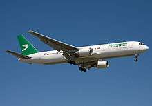
Turkmenistan's largest cities, Turkmenbashi and Ashgabat both have scheduled commercial air service. The largest airport is Ashgabat Airport, with regular international flights. Additionally, scheduled international flights are available to Turkmenbashi. The principal government-managed airline of Turkmenistan is Turkmenistan Airlines. It is also the largest airline operating in Turkmenistan. Turkmenistan Airlines' passenger fleet is composed only of American Boeing aircraft.[62] Air transport carries more than two thousand passengers daily in the country.[63] International flights annually transport over half a million people into and out of Turkmenistan. Turkmenistan Airlines operates regular flights to Moscow, London, Frankfurt, Birmingham, Bangkok, Delhi, Abu Dhabi, Amritsar, Kiev, Lviv, Beijing, Istanbul, Minsk, Almaty, Tashkent and St. Petersburg.
Maritime transport
.jpg)
Since 1962, the Turkmenbashi International Seaport operates a ferry to the port of Baku, Azerbaijan. In recent years there has been increased tanker transport of oil. The port of Turkmenbashi, associated rail ferries to the ports of the Caspian Sea (Baku, Aktau). In 2011, it was announced that the port of Turkmenbashi will be completely renovated. The project involves the reconstruction of the terminal disassembly of old and construction of new berths.[64][65]
Railway transport
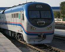
Rail is one of the main modes of transport in Turkmenistan. Trains have been used in the nation since 1876. Originally it was part of the Trans-Caspian railway, then the Central Asian Railway, after the collapse of the USSR, the railway network in Turkmenistan owned and operated by state-owned Türkmendemirýollary. The total length of railways – 3181 km. Passenger traffic railways of Turkmenistan is limited by national borders of the country, except in the areas along which the transit trains coming from Tajikistan to Uzbekistan and beyond. Locomotive fleet consists of a series of locomotives 2TE10L, 2TE10U, 2M62U also have several locomotives in China. Shunting locomotives operate TEM2, TEM2U, CME3. Currently under construction railway Kazakhstan-Turkmenistan-Iran and Turkmenistan-Afghanistan-Tajikistan.
See also
- Outline of Turkmenistan
- Index of Turkmenistan-related articles
- Central Asian Union
- Foreign relations of Turkmenistan
- Geok Tepe
- Military of Turkmenistan
- Scouting in Turkmenistan
- Transport in Turkmenistan
References
- ↑ https://www.constituteproject.org/constitution/Turkmenistan_2008.pdf
- ↑ Государственный комитет Туркменистана по статистике : Информация о Туркменистане : О Туркменистане : Туркменистан — одна из пяти стран Центральной Азии, вторая среди них по площади (491,21 тысяч км2), расположен в юго-западной части региона в зоне пустынь, севернее хребта Копетдаг Туркмено-Хорасанской горной системы, между Каспийским морем на западе и рекой Амударья на востоке.
- ↑ Department of Economic and Social Affairs Population Division (2009). "World Population Prospects, Table A.1" (PDF). 2008 revision. United Nations. Retrieved 12 March 2009.
- 1 2 3 4 "Turkmenistan". International Monetary Fund. Retrieved 2 June 2016.
- ↑ "2015 Human Development Report" (PDF). United Nations Development Programme. 2015. Retrieved 15 December 2015.
- ↑ Independence of Turkmenia Declared After a Referendum; New York Times - Oct. 28, 1991. Retrieved on Nov. 16, 2016.
- ↑ "The World Factbook". Cia.gov. Retrieved 25 November 2013.
- ↑ "Turkmenistan". Retrieved 6 November 2012.
- ↑ "Turkmenistan's Leader Promises Citizens Free Gas, Electricity and Water Through 2030". Fox News. 25 October 2006.
- ↑ "World Report 2014: Turkmenistan". Hrw.org. Retrieved 28 January 2015.
- 1 2 3 4 5 6 7 8 9 10 11 12 13 14 15 16 17 18 19 20 21 22 23 24 25 26 27 28 29 30 31 32 33 34 35 36 37 "Country Profile: Turkmenistan" (PDF). Library of Congress Federal Research Division. February 2007. Retrieved 25 November 2013.
- ↑ Paul R. Spickard (2005). Race and Nation: Ethnic Systems in the Modern World. Routledge. p. 260. ISBN 978-0-415-95003-9.
- ↑ Scott Cameron Levi (January 2002). The Indian Diaspora in Central Asia and Its Trade: 1550 – 1900. BRILL. p. 68. ISBN 978-90-04-12320-5.
- ↑ "Comments for the significant earthquake". Significant Earthquake Database. National Geophysical Data Center. Retrieved 12 June 2015.
- ↑ "Turkmenistan president wins election with 96.9% of vote". London: theguardian.com. 13 February 2012. Retrieved 25 November 2013.
- ↑ "Turkmenistan". Retrieved 12 February 2016.
- ↑ "A/RES/50/80. Maintenance of international security". un.org.
- ↑ "Diplomatic relations". Mfa.gov.tm. Retrieved 14 February 2016.
- ↑ "Russians 'flee' Turkmenistan". BBC News. 20 June 2003. Retrieved 25 November 2013.
- ↑ "Turkmenistan: Russian Students Targeted". Institute for War and Peace Reporting. 21 February 2005. Retrieved 25 November 2013.
- ↑ "Alternative report on the Human Rights situation in Turkmenistan for the Universal Periodic Review" (PDF) (Press release). FIDH. Retrieved 23 July 2010.
- ↑ "Reporters Without Borders". rsf.org. Retrieved 14 February 2016.
- ↑ "10 Most Censored Countries". Cpj.org. Retrieved 30 January 2012.
- ↑ "Turkmenistan: International Religious Freedom Report 2004". www.state.gov/. United States Department of State, Bureau of Democracy, Human Rights, and Labor. 21 May 2015. Retrieved 15 March 2016.
- ↑ "Turkmenistan 2015/2016: Freedom of religion". www.amnesty.org. Retrieved 15 March 2016.
- ↑ "One Year of Unjust Imprisonment in Turkmenistan". jw.org.
- ↑ Forrester, Chris (22 April 2015). "Satellite dishes banned in Turkmenistan". Advanced Television. Retrieved 23 April 2015.
- 1 2 Statistical Yearbook of Turkmenistan 2000–2004, National Institute of State Statistics and Information of Turkmenistan, Ashgabat, 2005.
- ↑ Kuh-e Rizeh on Peakbagger.com
- ↑ "Mount Arlan". Peakbagger.com. 1 November 2004. Retrieved 30 January 2012.
- ↑ "Ayrybaba". Peakbagger.com. 1 November 2004. Retrieved 25 November 2013.
- ↑ "Premium content". Economist.com. 9 July 2009. Retrieved 3 May 2010.
- 1 2 3 4 "Turkmenistan". CIA World Factbook. Retrieved 25 November 2013.
- ↑ Resolution of Khalk Maslahati (Peoples' Council of Turkmenistan) N 35 (14 August 2003)
- ↑ "Business | Russia reaches Turkmen gas deal". BBC News. 5 September 2006. Retrieved 3 May 2010.
- ↑ Solovyov, Dmitry (25 May 2011). "Turkmen gas field to be world's second-largest". Reuters.
- 1 2 "Turkmenistan. Diversifying export routes". Europarussia.com. 3 February 2010. Retrieved 25 November 2013.
- ↑ "China plays Pipelineistan'". Atimes.com. 24 December 2009. Retrieved 3 May 2010.
- ↑ "Turkmenistan Oil and Gas". Turkmenistanoil.tripod.com. Retrieved 25 November 2013.
- ↑ "Turkmenistan study". Countrystudies.us. Retrieved 25 November 2013.
- ↑ "The ten largest cotton producing countries in 2009". Statista.com. Retrieved 25 November 2013.
- ↑ "Turkmenistan to Privilege US Farm Machinery Manufacturers". The Gazette of Central Asia. Satrapia. 26 July 2012. Retrieved 4 August 2012.
- ↑ "Las Vegas on the Caspian?". aljazeera.com.
- ↑ Moya Flynn (2004). Migrant Resettlement in the Russian Federation: Reconstructing 'homes' and 'homelands'. Anthem Press. p. 15. ISBN 978-1-84331-117-1.
- ↑ "Ethnic composition of Turkmenistan in 2001" (37–38). Demoscope Weekly. 14 April 2001. Retrieved 25 November 2013.
- ↑ Ethnologue (19 February 1999). "Ethnologue". Ethnologue. Retrieved 25 November 2013.
- ↑ http://www.pewforum.org/files/2009/10/Muslimpopulation.pdf.
- ↑ "MAPPING THE GLOBAL MUSLIM POPULATION : A Report on the Size and Distribution of the World's Muslim Population" (PDF). Pweforum.org. October 2009. Retrieved 14 February 2016.
- ↑ Larry Clark; Michael Thurman & David Tyson (March 1996). Glenn E. Curtis, ed. "A Country Study: Turkmenistan". Library of Congress Federal Research Division. Retrieved 25 November 2013.
- ↑ "Asia-Pacific | Turkmen drivers face unusual test". BBC News. 2 August 2004. Retrieved 3 May 2010.
- ↑ "Turkmenistan". Bahai-library.com. Retrieved 12 September 2011.
- ↑ (Duane L. Herrmann) "Houses As perfect As Is Possible" World Order (Fall 1994) pp.17–31
- ↑ "Turkmenistan: International Religious Freedom Report 2004". www.state.gov/. United States Department of State, Bureau of Democracy, Human Rights, and Labor. 21 May 2015. Retrieved 15 March 2016.
- ↑ UNESCO World Heritage Centre (26 January 2009). "Ancient Merv State Historical and Cultural Park". Whc.unesco.org. Retrieved 25 November 2013.
- ↑ UNESCO World Heritage Centre (15 July 2005). "Köneürgenç". Whc.unesco.org. Retrieved 25 November 2013.
- ↑ UNESCO World Heritage Centre. "Nisa Fortress". Whc.unesco.org. Retrieved 25 November 2013.
- ↑ "Retrieved: 5 April 2013". Internetworldstats.com. Retrieved 25 November 2013.
- ↑ "CIA – The World Factbook". Cia.gov. Retrieved 30 January 2012.
- ↑ "Turkmenistan adopts 12-year secondary education". Trend. 2 March 2013.
- ↑ "Turkmenistan: golden age". turkmenistan.gov.tm.
- ↑ "Туркменистан: Ниязов решил добить уволенного министра траспорта". Uadaily.net. Retrieved 25 November 2013.
- ↑ "Мы не подведём". Ogoniok.com. Retrieved 25 November 2013.
- ↑ V@DIM. "Могучие крылья страны". Turkmenistan.gov.tm. Retrieved 25 November 2013.
- ↑ "Порт Туркменбаши будет полностью реконструирован". Portnews.ru. Retrieved 25 November 2013.
- ↑ V@DIM (16 May 2012). "Определены приоритетные направления развития транспорта и транзита в регионе". Turkmenistan.gov.tm. Retrieved 25 November 2013.
Further reading
- Brummel, Paul (2006). Bradt Travel Guide: Turkmenistan. Bradt Travel Guides. ISBN 978-1841621449.
- Abazov, Rafis (2005). Historical Dictionary of Turkmenistan. Scarecrow Press. ISBN 978-0810853621.
- Clammer, Paul; Kohn, Michael; Mayhew, Bradley (2014). Lonely Planet Guide: Central Asia. Lonely Planet. ISBN 978-1741799538.
- Hopkirk, Peter (1992). The Great Game: The Struggle for Empire in Central Asia. Kodansha International. ISBN 978-1568360225.
- Blackwell, Carole (2001). Tradition and Society in Turkmenistan: Gender, Oral Culture and Song. Routledge. ISBN 978-0700713547.
- Kaplan, Robert (2001). Eastward to Tartary: Travels in the Balkans, the Middle East, and the Caucasus. Vintage. ISBN 978-0375705762.
- Kropf, John (2006). Unknown Sands: Journeys Around the World's Most Isolated Country. Dusty Spark Publishing. ISBN 978-0976356516.
- Rall, Ted (2006). Silk Road to Ruin: Is Central Asia the New Middle East?. NBM Publishing. ISBN 978-1561634545.
- Theroux, Paul (28 May 2007). "The Golden Man: Saparmurat Niyazov's reign of insanity.". The New Yorker.
- Vilmer, Jean-Baptiste (2009). Turkménistan (in French). Editions Non Lieu. ISBN 978-2352700685.
External links
- "Turkmenistan". The World Factbook. Central Intelligence Agency.
- Modern Turkmenistan photos
- Turkmenistan at UCB Libraries GovPubs
- Turkmenistan at DMOZ
- Turkmenistan profile from the BBC News
 Wikimedia Atlas of Turkmenistan
 Turkmenistan travel guide from Wikivoyage
- Key Development Forecasts for Turkmenistan from International Futures
- Government
- Turkmenistan government information portal
- Chief of State and Cabinet Members
- Tourism Committee of Turkmenistan
- Other
- "Chronicles of Turkmenistan". Publication of Turkmen Initiative for Human Rights.
- The Turkmenistan Project – weekly news and analysis in English and Russian
- Official photo gallery from Turkmenistan and Ashgabat
- daily news and analysis in Turkish English and Turkmen
Turkmenistan articles | |||||||
|---|---|---|---|---|---|---|---|
| History |  | ||||||
| Geography | |||||||
| Politics | |||||||
| Economy | |||||||
| Society |
| ||||||
| |||||||
.svg.png)
| International membership | |||||||||||||||||||||||||||||||||||||||||||||||||||||||||||||||||||||||||
|---|---|---|---|---|---|---|---|---|---|---|---|---|---|---|---|---|---|---|---|---|---|---|---|---|---|---|---|---|---|---|---|---|---|---|---|---|---|---|---|---|---|---|---|---|---|---|---|---|---|---|---|---|---|---|---|---|---|---|---|---|---|---|---|---|---|---|---|---|---|---|---|---|---|
| |||||||||||||||||||||||||||||||||||||||||||||||||||||||||||||||||||||||||