Texas State Highway 90
| ||||
|---|---|---|---|---|
 | ||||
| Route information | ||||
| Maintained by TxDOT | ||||
| Length: | 42.07 mi[1] (67.71 km) | |||
| Existed: | 1926 – present | |||
| Major junctions | ||||
| South end: |
| |||
|
| ||||
| North end: |
| |||
| Highway system | ||||
| ||||

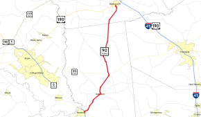
State Highway 90 or SH 90 is a state highway that runs 42 miles (68 km) between Madisonville, Texas and Navasota. It was originally designated by 1933 along its current route, except that it extended southwest from Navasota to Brenham. This section was transferred to SH 105 in 1973.
History
The routing between Madisonville and Navasota was originally set before the state's highway system was started. By 1919, a rail route between the cities existed, run by the Great Northern Railroad. By 1922, a basic highway had been built between the cities, which was designated as State Highway 32A, which branched off the main State Highway 32 in Madisonville. By 1926, the state roads department had begun to get rid of most suffixed spur routes, so this route was again renumbered as State Highway 90. The route remained a minimally serviced dirt road until the early 1930s, when paving occurred. Numerous reroutings occurred during the next 70 years, including being rerouted away from the town of Washington and the eventual transferral of the section between Brenham and Navasota to State Highway 105 in 1973.
Route description
SH 90 begins at an intersection with State Highway 6 and State Highway 105 on the northeast side of Navasota. The route travels to the northeast, first passing Navasota High School. It then travels through the western side of Anderson, passing a block west of the Grimes County Courthouse. It continues north out of Anderson through central Texas farmlands. It reaches Roans Prairie and an intersection with State Highway 30. It continues north through Bedias and other lightly populated sections of Grimes County before entering Madison County. The route enters Madisonville from the south, reaching an intersection with South Street. It turns east at South Street, reaching its northern terminus two blocks later at State Highway 75 (formerly US Route 75), while State Spur 174 continues northward from South Street to an intersection with US Route 190 and State Highway 21.
Junction list
| County | Location | mi | km | Destinations | Notes |
|---|---|---|---|---|---|
| Grimes | Navasota | ||||
| | |||||
| | |||||
| | |||||
| | |||||
| Roans Prairie | |||||
| | |||||
| Bedias | |||||
| Madison | | ||||
| Madisonville | |||||
| 1.000 mi = 1.609 km; 1.000 km = 0.621 mi | |||||