List of Recreational Roads in Texas
| Recreational Roads | |
|---|---|
|
Texas Recreational Road markers | |
| System information | |
| Length: | 80.5 mi (129.6 km) |
| Formed: | April 1, 1970[1] |
| Highway names | |
| Interstates: |
Interstate X (I-X) Interstate Highway X (IH-X) |
| US Highways: | U.S. Highway X (US X) |
| State: | State Highway X (SH X) |
| Loops: | Loop X |
| Spurs: | Spur X |
| Recreational: | Recreational Road X (RE X) |
| Farm or Ranch to Market Roads: |
Farm to Market Road X (FM X) Ranch to Market Road X (RM X) |
| Park Roads: | Park Road X (PR X) |
| System links | |


Recreational Roads (RE) are a secondary state highway system located in the U.S. state of Texas, and are created and maintained by the Texas Department of Transportation (TxDOT). Similar to the state's Park Road system, routes on the Recreational Road system provide access to recognized recreation areas, such as those operated by the National Park Service. However, Park Roads provide access to state-maintained parks. Recreational Roads currently make up approximately 80.5 miles (129.6 km) of Texas's highway system. The longest route in the system is Recreational Road 255 (RE 255), while the shortest route in the system is RE 6. Recreational Roads are signed with a route marker that is very similar to the sign which marks the Farm to Market Road system, with just a few differences. The most noticeable difference is that the base color for the Farm to Market Road marker is black, while the base color for the Recreational Road sign is brown.
The system was created on April 1, 1970, by TxDOT Minute Order 063535, which redesignated a portion of Farm to Market Road 255 (FM 255), as RE 255. Except for RE 255, TxDOT numbers the recreational routes sequentially. RE 2 is the system's second oldest route, and is numbered accordingly, while RE 11 is the system's eleventh route, the newest one, and is numbered as such. Only a few highways on the system were created from preexisting routes. One route on the system has been cancelled. The TxDOT defined one type of auxiliary route for the system, although no highway from the system currently exists.
Overview
History
The Recreational Road System began on April 1, 1970, when TxDOT Minute Order 063535 was passed, designating RE 255 and RE 2. Two weeks later, on April 15, the TxDOT's Administration Circle approved the route of RE 255, and authorized its creation.[2] On May 7, 1970, the TxDOT designated RE 3, and on June 1 of the same year, both RE 2 and RE 3 were approved for creation by the Administration Circle. On September 1, RE 4 was designated, and was approved on October 15, 1970. On April 3, 1972, RE 5 was designated, and was approved less than two weeks later. In October of the same year, RE 6 was designated and approved. On the first of April, 1981, RE 7 was designated and approved. Later that month, RE 8, was designated, and in June of that year, it was approved. On October 31, 1993, RE 9 was designated, and it was approved in December. In October 1996, RE 10 was designated, and it was approved on December 20. RE 11, was the last route to be created, being approved on December 20, 1996.[3] On July 10, 2012, RE 5 was cancelled from the system, and turned over to the control of Polk County.[4] It is currently the only Recreational Road to have been completely canceled. RE 255 and RE 8 are the only routes in the system that have been edited.[3]
System description
The system is maintained and overseen by the TxDOT. The DOT defines a route on the system as a "Roadway to a recognized recreational area, so designated by the Texas Transportation Commission". Routes on the system are very similar to those on the Park Road system, except that a Park Road is defined as "Roadway to a recognized state or national park".[5] Currently, RE 8 is the only route which deviates from the system, as it serves Choke Canyon State Park.[6] The system makes up 80.5 miles (129.6 km) of Texas' state highway system; the longest Recreational Road is RE 255, at approximately 56.6 miles (91.1 km), while the shortest route in the system is RE 6 at just 0.3 miles (0.48 km).[1]
Recreational Roads are signed with a reassurance marker, or highway shield, that is very similar to the one used for the Farm to Market Road System. The Recreational Road marker, like the Farm to Market Road shield, is rectangular, with the shape of the state of Texas located in the center, with the route number in the center of that. While the FM shield has the word "FARM" located in the top right corner, and the word "ROAD" located in the bottom right corner, the RE shield has the letter "R" located in the top right corner instead. The base color for the FM shield is black, while the base color for the RE shield is brown. The shields are square in shape, with the dimensions of 24 by 24 inches (61 cm × 61 cm) or 36 by 36 inches (91 cm × 91 cm).[7]
Auxiliary routes
Recreational Road Spurs (RPs) are a type of auxiliary route for the Recreational Road System. The TxDOT defines a Recreational Road Spur as a "roadway which usually begins on an on-system roadway and ends on an off-system roadway".[5] There are currently no Recreational Road Spurs in existence.[8] RE 255 is the only Recreational Road to have had a spur route. The 0.7-mile-long (1.1 km) route was originally designated on February 15, 1970, as FM 255 Spur; it connected FM 255 to the community of Beans through a short, heavily wooded area. The spur was redesignated as RP 255 on March 15, 1974, and was cancelled on December 18, 1979.[2][9]
Highways
Recreational Road 2
| |
|---|---|
| Location: | Val Verde County |
| Length: | 7.198 mi[10] (11.584 km) |
| Existed: | 1970–present |
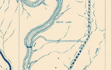
Recreational Road 2 connects U.S. Routes 277 and 377 to the Rough Canyon Recreational Area portion of Amistad National Recreation Area. The road begins at boat-launch ramp on Devils River at the northern end of the Amistad Reservoir. The roadway runs northeasterly past the Rough Canyon Campground, past a small mobile home park, still inside the national recreation area.[11] RE 2 turns directly east at an intersection with Cam Real Road, which connects the route to the community of Devils Shores. The highway exits the park, and continues through the South Texas shrubland, passing a few small roads and homes as well as traveling over several dry creek beds. The highway runs through several miles of shrubland before it reaches its western terminus, an at-grade intersection with US 277/US 377.[12][13] A primitive dirt road first appeared in the location of RE 2 by 1940.[14] Between 1956 and 1961, the road's surface was improved from gravel to metal and its course had been gradually straightened.[15][16] RE 2 was designated on June 1, 1970, making it the second route in the system.[10]
Recreational Road 3
| |
|---|---|
| Location: | Fannin County |
| Length: | 2.037 mi[17] (3.278 km) |
| Existed: | 1970[17]–present |
Recreational Road 3 connects FM 273 to Fannin County Road 2610 (CR 2610) and serves Lake Bonham Park. The highway begins at an intersection with FM 273, north of Bonham. From there, the highway travels eastward for approximately 0.1 miles (0.16 km), passing rural areas, before bending northward. The road travels north for about 0.2 miles (0.32 km), passing more rural areas. The highway bends eastward afterward. It passes several small neighborhoods, and parts of Lake Bonham, before turning in a northeast direction. The roadway intersects several county roads before it passes the small Lake Bonham Park and reaches its eastern terminus, an intersection with the Old Bonham Road (CR 2610).[18][19] RE 3 was designated on June 1, 1970, from an intersection with FM 898 to an intersection with Old Lake Bonham Road, in Fannin County, along its current route. The road was approximately 2.2 miles (3.5 km) in length at the time of designation, but has since been shortened by about 0.2 miles (0.32 km).[17] FM 898 was redesignated as FM 273 on April 1, 2004.[20]
Major intersections
The entire highway is located within Fannin County.
| mi[8] | km | Destinations | Notes | ||
|---|---|---|---|---|---|
| 0.000 | 0.000 | Western terminus | |||
| 1.293 | 2.081 | CR 5351 | Northern terminus of CR 5350 | ||
| 1.769 | 2.847 | CR 5350/Lake Bonham Park | Northern terminus of CR 5351; entrance to Lake Bonham Park | ||
| 2.037 | 3.278 | Old Lake Bonham Road (CR 2610) | Eastern terminus | ||
| 1.000 mi = 1.609 km; 1.000 km = 0.621 mi | |||||
Recreational Road 4
| |
|---|---|
| Location: | Burleson County |
| Length: | 3.284 mi[21] (5.285 km) |
| Existed: | 1970[21]–present |
Recreational Road 4 connects FM 60 to the entrance of Big Creek Park. The roadway begins at an at-grade intersection with FM 60, northwest of Somerville. The highway proceeds southwest, passing a few small fields before intersecting Burleson County Road 472 (CR 472). The road proceeds, bending southeastward and passing a few small houses and fields. The roadway continues southeast, passing a few small ranches and intersecting a small road. The road continues, passing several houses, on the edge of a small, unnamed community. The roadway continues past a few more small houses and ranches, before intersecting CR 415. The road proceeds southeast, passing a few more ranches, before it intersects CR 416 and proceeds past a small residential area. The route passes a few more ranches before reaching its southern terminus, the entrance gate to Big Creek Park. A small park road continues from the route.[22][23] RE 4 was approved on September 1, 1970, and was officially designated on October 15, 1970, traveling in its present location from FM 60 to Big Creek Park. The highway has not since been extended or rerouted.[21]
Major intersections
The entire highway is located within Burleson County.
| mi[8] | km | Destinations | Notes | ||
|---|---|---|---|---|---|
| 0.000 | 0.000 | Northern terminus | |||
| 1.883 | 3.030 | Northern terminus of CR 415 | |||
| 2.352 | 3.785 | Northern terminus of CR 416 | |||
| 3.284 | 5.285 | Big Creek Park | Southern terminus | ||
| 1.000 mi = 1.609 km; 1.000 km = 0.621 mi | |||||
Recreational Road 5
| |
|---|---|
| Location: | Polk County |
| Length: | 0.906 mi[4] (1.458 km) |
| Existed: | April 15, 1972–July 10, 2012 |
Recreational Road 5 functioned as the main road for Southland Park, and connected it to FM 1988. The route began at an intersection with FM 1988, south of Lake Livingston, as a two-lane, paved road. The highway passed a few small houses and a small field, while traveling parallel to a small dirt road. RE 5 entered the small Southland Park, where it proceeded southeastward. The road formed a small loop inside the park, passing park facilities, hiking trails, the Trinity River and several parking spaces. The highway continued to its southern terminus, an at-grade intersection with itself at the end of the loop.[24][25] Recreational Road 5 was approved on April 3, 1972, but was not designated until April 15, 1972. The original route traveled in its present location from FM 1988 to Southland Park, for a length of approximately 1.1 miles (1.8 km). The route was later shortened by about 0.2 miles (0.32 km). On May 31, 2012, the route was proposed for cancellation, which was approved on July 10, 2012. The road was turned back to the control of Polk County.[4]
Major intersections
The entire highway was located within Polk County.
| mi[8] | km | Destinations | Notes | ||
|---|---|---|---|---|---|
| 0.000 | 0.000 | Northern terminus | |||
| 0.906 | 1.458 | End of in-park loop | Southern terminus | ||
| 1.000 mi = 1.609 km; 1.000 km = 0.621 mi | |||||
Recreational Road 6
| |
|---|---|
| Location: | Comanche County |
| Length: | 0.300 mi[26] (0.483 km) |
| Existed: | 1972[26]–present |
Recreational Road 6 connects FM 1476 to Sowell Creek Park. The highway begins at an at-grade intersection with the main park road to Sowell Creek Park, on Proctor Lake, as a two-lane, paved road. RE 6 travels northward, while Comanche County Road 5132 (CR 5132) continues southward along the lake. The road proceeds north, passing a small house to the east and two large fields to either side, as it travels parallel to the coast of Proctor Lake. The roadway continues to its northern terminus, an at-grade intersection with FM 1476.[27][28][29] RE 6 was approved on October 5, 1972, and was designated on October 15, 1972, traveling in its present location from Sowell Creek Park to FM 1476. The highway has not since been extended or rerouted.[26] RE 6 is currently the shortest route in the Recreational Road System.[5]
Major intersections
The entire highway is located within Comanche County.
| mi[8] | km | Destinations | Notes | ||
|---|---|---|---|---|---|
| 0.000 | 0.000 | CR 5132 Entrance to Sowell Creek Park | Southern terminus | ||
| 0.300 | 0.483 | Northern terminus | |||
| 1.000 mi = 1.609 km; 1.000 km = 0.621 mi | |||||
Recreational Road 7
| |
|---|---|
| Location: | McMullen County |
| Length: | 2.400 mi[30] (3.862 km) |
| Existed: | April 3, 1981[30]–present |
Recreational Road 7 connects State Highway 72 (TX 72) to a recreational area on Choke Canyon Reservoir. The highway begins at an at-grade intersection with TX 72, located several miles east of the unincorporated community of Tilden, as a two-lane, paved road. McMullen County Road 304 (CR 304) proceeds southward from the intersection. RE 7 travels northward for a very short distance, before turning northeastward, proceeding through rural areas. The road continues past a small reservoir and an oil drilling station before re-entering rural land and following northeast to its northern terminus, the designated end of state maintenance. A short park road continues northeasterly to the reservoir, and ends at a boat-launch ramp.[31][32] RE 7 was approved on April 3, 1981, traveling in its present location from SH 72 to Choke Canyon Reservoir, and was designated later that year. The highway has not since been extended or rerouted.[30]
Major intersections
The entire highway is located within McMullen County.
| mi[8] | km | Destinations | Notes | ||
|---|---|---|---|---|---|
| 0.000 | 0.000 | Southern terminus | |||
| 2.400 | 3.862 | Choke Canyon Reservoir | Northern terminus | ||
| 1.000 mi = 1.609 km; 1.000 km = 0.621 mi | |||||
Recreational Road 8
| |
|---|---|
| Location: | McMullen County |
| Length: | 1.058 mi[33] (1.703 km) |
| Existed: | 1981[33]–present |
Recreational Road 8 connects TX 72 to the community of Calliham and Choke Canyon State Park. The highway begins at an intersection with TX 72, near Calliham, as a two-lane, paved road. The roadway proceeds northward, passing a large field before entering Calliham, and passing a few small houses. The road continues northward, passing several houses and businesses, and intersecting several small roads. RE 8 continues past more houses and businesses and a small trailer park, and intersecting several small roads. The road continues north, passing a small field and a few more houses, before reaching its northern terminus, an intersection with Quail Run. A park road continues northward through Choke Canyon State Park, passing several campgrounds and ending at a small loop near the reservoir.[31][34] Recreational Road 8 was approved on April 3, 1981 and was officially designated on June 15, 1981. The original route traveled from FM 99 southward approximately 1.6 miles (2.6 km) to the Choke Canyon Reservoir, due to the relocation of FM 99.This designation replaced an original designation as FM 99.[33][35] On June 29, 1983 the relocation of the route was approved, and on August 16, 1983, the original designation was cancelled, and RE 8 was transferred to its present location on the southern side of the reservoir.[33]
Recreational Road 9
| |
|---|---|
| Location: | Coleman County |
| Length: | 1.291 mi[36] (2.078 km) |
| Existed: | 1993[36]–present |
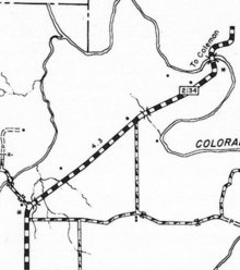
Recreational Road 9 connects FM 2134 to a recreational area on the O.H. Ivie Reservoir. The highway begins at an intersection with FM 2134, near Talpa, as a two-lane, paved road. RE 9 proceeds northwest, passing through rural areas. The roadway bends westward and proceeds through more rural land, passing two oil drilling sites and intersecting a private dirt county road. The highway continues through more rural areas, where it passes a small pond and intersects CR 329. The road continues west, entering Padgitt Park and intersecting two short, unpaved park roads before it passes a few trails. The highway intersects a small dirt road before reaching its western terminus, the designated end of state maintenance. A park road continues a very brief distance westward, proceeding to a boat-launch ramp located on the O. H. Ivie Reservoir.[37][38] Recreational Road 9 approved on October 31, 1993 and was officially designated on December 20, 1993, in its current location, traveling from FM 2134 westward to Padgitt Park, with a length of 1.4 miles (2.3 km). The highway has since been shortened by appropriately 0.2 miles (0.32 km) in length.[36]
Major intersections
The entire highway is located within Coleman County.
| mi[8] | km | Destinations | Notes | ||
|---|---|---|---|---|---|
| 0.000 | 0.000 | Eastern terminus | |||
| 0.925 | 1.489 | ||||
| 1.291 | 2.078 | Padgitt Park | Western terminus | ||
| 1.000 mi = 1.609 km; 1.000 km = 0.621 mi | |||||
Recreational Road 10
| |
|---|---|
| Location: | Coleman County |
| Length: | 1.070 mi[39] (1.722 km) |
| Existed: | December 10, 1996[39]–present |
Recreational Road 10 connects FM 1929 to Kennedy Park on the O.H. Ivie Reservoir. The highway begins at an intersection with FM 1929, south of the O. H. Ivie Reservoir, as a two-lane, paved road. RE 8 proceeds northward, passing a four small buildings and intersecting two unpaved county roads. The road bends northwest, splitting from a small dirt road and proceeding through rural brushland, where it enters Kennedy Park. The highway bends around several small buildings, and intersects a few roads, which make up part of the Elm Creek Village. It also intersects an unpaved park road which leads to several campgrounds. The road intersects Elm Creek Croad, and bends eastward. The route passes several park facilities before reaching its northern terminus, the designated end of state maintenance, at a small parking lot. A road continues a short distance northward, proceeding to a boat-launch ramp located on the O.H. Ivie Reservoir.[40][41] Recreational Road 10 was approved on October 31, 1996, and was officially designated on December 10, 1996 to its current location, traveling from FM 1929 northward to Kennedy Park. The route's original length was approximately 0.8 miles (1.3 km), which has since been extended by about 0.2 miles (0.32 km).[39]
Major intersections
The entire highway is located within Coleman County.
| mi[8] | km | Destinations | Notes | ||
|---|---|---|---|---|---|
| 0.000 | 0.000 | Southern terminus | |||
| 0.063 | 0.101 | Western terminus of CR 332 | |||
| 0.152 | 0.245 | Northern terminus of CR 318 | |||
| 1.070 | 1.722 | Kennedy Park | Northern terminus | ||
| 1.000 mi = 1.609 km; 1.000 km = 0.621 mi | |||||
Recreational Road 11
| |
|---|---|
| Location: | Concho County |
| Length: | 4.251 mi[42] (6.841 km) |
| Existed: | 1996[42]–present |
Recreational Road 11 connects FM 1929 to a recreational area on the O.H. Ivie Reservoir. The highway begins at an intersection with FM 1929, south of the O. H. Ivie Reservoir, as a two-lane, paved road. RE 11 proceeds northward, passing through rural area on a large peninsula and intersecting a few private ranch roads. The road continues northward, passing more rural areas, where it intersects Concho County Highway 4763 (CR 3763). The highway continues northward through more rural land before bending northeast and intersecting the route of former RM 2134. The road proceeds northeast, though rural area, before intersecting CR 4763, and bending northward. The roadway continues northward, intersecting a few small park roads before bending northwest. The road proceeds northwest, passing campgrounds and other park facilities before passing a parking lot and a boat-launch ramp. The route proceeds to its northern terminus, a separate boat launch ramp on the coast of O.H. Ivie Reservoir.[40][43]
Two separate roads first appeared by 1940 along a portion of where RE 11 is currently located. Both roads were graded and gravel surfaced.[44] On August 24, 1955, RM 2134 was designated along the northern road segment.[45] By 1956, the route's surface was improved to stone, and on December 1, 1957, RM 2134 was extended.[15][45] By 1961, the portion designated as RM 2134 had been upgraded to a bituminous surface and other road segment had been upgraded to a metal surface.[46] The RM 2134 designation was removed from the roadway by 1990, due to the construction of the O.H. Ivie Reservoir over portions of the roadway.[47] Recreational Road 11 was designated on December 20, 1996, in its current location, traveling from FM 1929 northward to the Concho Recreation Area.[42]
Recreational Road 255
| |
|---|---|
| Location: | Tyler County–Jasper County |
| Length: | 56.596 mi[2] (91.082 km) |
| Existed: | 1970–present |
Recreational Road 255 is located in Tyler, Jasper, and Newton counties, in the southeastern region of Texas. The highway is approximately 56.6 miles (91.1 km) long, and travels through mainly rural areas in the northern portion of the three counties.[2] RE 255 begins at an intersection with U.S. Route 69 (US 69), in Tyler County, near the city of Colmesneil. The route travels through rural farmland in northern Tyler County, where it intersects numerous county roads before it crosses the Neches River into Jasper County.[48] The roadway intersects State Highway 63 (TX 63) and US 96, and helps form part of the Sam Rayburn Dam. The road passes through several small communities while in Jasper County.[49][50] The route continues into Newton County, where it intersects TX 87 and travels through additional forested rural areas before terminating at an intersection with Farm to Market Road 692 (FM 692), near the Louisiana border.[51] RE 255 provides access to much of the southern portion of Angelina National Forest, the Sam Rayburn Reservoir, and the Toledo Bend Reservoir. The highway also provides access to several small recreational areas along both lakes.[52]
Recreational Road 255 began as Farm to Market Road 255, with the first section of the route being designated in 1945.[2] Throughout the 1950s and the 1960s, FM 255 was extended multiple times, with the final extension being made in early 1970. The first stretch of RE 255 was designated over FM 255 on April 1, 1970, creating the first Recreational Road. The highway was extended three more times in the 1970s, completely replacing FM 255.[2] FM 255 had a short spur that was designated in 1970, and was transferred over to RE 255 in 1974 when the main route was replaced. RE 255 Spur was cancelled in 1979.[2][53] RE 255 is currently located within the study area of the proposed Interstate 14, the Gulf Coast Strategic Highway.[54][55]
See also
 Texas portal
 U.S. Roads portal
References
- 1 2 Transportation Planning and Programming Division. "Recreational Road Facts". Texas Department of Transportation. Retrieved December 20, 2009.
- 1 2 3 4 5 6 7 Transportation Planning and Programming Division (n.d.). "Recreational Road No. 255". Highway Designation Files. Texas Department of Transportation. Retrieved December 20, 2009.
- 1 2 Transportation Planning and Programming Division. "Highway Designation Files: Search for 'RE–Recreational Road'". Texas Department of Transportation. Retrieved July 31, 2012.
- 1 2 3 Transportation Planning and Programming Division (n.d.). "Recreational Road No. 5". Highway Designation Files. Texas Department of Transportation. Retrieved June 22, 2012.
- 1 2 3 Transportation Planning and Programming Division. "Highway Designations Glossary". Texas Department of Transportation. Retrieved December 20, 2009.
- ↑ Parent, Laurence (2008). Official Guide to Texas State Parks and Historic Sites (2nd ed.). Austin, TX: University of Texas Press. p. 173. ISBN 978-0-292-71726-8.
- ↑ Staff. "TxDOT Official Sign Detail" (PDF). Texas Department of Transportation. pp. 3–5.5–3–5.8. Retrieved July 31, 2012.
- 1 2 3 4 5 6 7 8 Transportation Planning and Programming Division (2013). Statewide Planning Map (Map). Texas Department of Transportation. Retrieved November 12, 2012.
- ↑ A.I.D. Associates (1972). Sam Rayburn Reservoir and Dam B (Map) (1972 ed.). A.I.D. Associates.
- 1 2 Transportation Planning and Programming Division (n.d.). "Recreational Road No. 2". Highway Designation Files. Texas Department of Transportation. Retrieved April 7, 2012.
- ↑ National Park Service (2013). Amistad National Recreation Area Map (Map). National Park Service. Retrieved June 4, 2013.
- ↑ Google (April 7, 2012). "Overview Map of Recreational Road 2" (Map). Google Maps. Google. Retrieved April 7, 2012.
- ↑ Transportation Planning and Programming Division (2014). Texas County Map Book (PDF) (Map) (2014 ed.). 1:120,000. Texas Department of Transportation. p. 192. Retrieved June 21, 2015.
- ↑ State-Wide Highway Planning Survey (February 1, 1940). General Highway Map Val Verde County Texas (Map) (1936 ed.). 1 in=2 mi. Texas State Highway Department.
- 1 2 H.M. Gousha Company (1956). Highway Map of Texas (Map) (1956 ed.). 1 in=26 mi. Shell Oil Company. § K7.
- ↑ Planning Survey Division (January 1, 1961). General Highway Map Val Verde County Texas (Map) (1958 ed.). 1 in=4 mi. Texas State Highway Department.
- 1 2 3 Transportation Planning and Programming Division (n.d.). "Recreational Road No. 3". Highway Designation Files. Texas Department of Transportation. Retrieved April 7, 2012.
- ↑ Transportation Planning and Programming Division (2014). Texas County Map Book (PDF) (Map) (2014 ed.). 1:120,000. Texas Department of Transportation. p. 440. Retrieved June 21, 2015.
- ↑ Google (April 7, 2012). "Overview Map of Recreational Road 3" (Map). Google Maps. Google. Retrieved April 7, 2012.
- ↑ Transportation Planning and Programming Division (n.d.). "Farm to Market Road No. 898". Highway Designation Files. Texas Department of Transportation. Retrieved June 24, 2013.
- 1 2 3 Transportation Planning and Programming Division (n.d.). "Recreational Road No. 4". Highway Designation Files. Texas Department of Transportation. Retrieved June 22, 2012.
- ↑ Transportation Planning and Programming Division (2014). Texas County Map Book (PDF) (Map) (2014 ed.). 1:120,000. Texas Department of Transportation. p. 452. Retrieved June 21, 2015.
- ↑ Google (June 22, 2012). "Overview Map of Texas Recreational Road 4" (Map). Google Maps. Google. Retrieved June 22, 2012.
- ↑ Transportation Planning and Programming Division (2010). Texas County Map Book (Map) (2010 ed.). 1:120,000. Texas Department of Transportation. p. 579. Archived from the original (PDF) on August 12, 2012. Retrieved June 22, 2012.
- ↑ Google (June 22, 2012). "Overview Map of Texas Recreational Road 5" (Map). Google Maps. Google. Retrieved June 22, 2012.
- 1 2 3 Transportation Planning and Programming Division (n.d.). "Recreational Road No. 6". Highway Designation Files. Texas Department of Transportation. Retrieved June 23, 2012.
- ↑ Transportation Planning and Programming Division (2014). Texas County Map Book (PDF) (Map) (2014 ed.). 1:120,000. Texas Department of Transportation. p. 330. Retrieved June 21, 2015.
- ↑ U.S. Department of Defense (August 2004). Proctor Lake (Map). U.S. Army Corps of Engineers. Retrieved June 23, 2012.
- ↑ Google (June 23, 2012). "Overview Map of Texas Recreational Road 6" (Map). Google Maps. Google. Retrieved June 23, 2012.
- 1 2 3 Transportation Planning and Programming Division (n.d.). "Recreational Road No. 7". Highway Designation Files. Texas Department of Transportation. Retrieved June 23, 2012.
- 1 2 Transportation Planning and Programming Division (2014). Texas County Map Book (PDF) (Map) (2014 ed.). 1:120,000. Texas Department of Transportation. p. 343. Retrieved June 21, 2015.
- ↑ Google (June 23, 2012). "Overview Map of Texas Recreational Road 7" (Map). Google Maps. Google. Retrieved June 23, 2012.
- 1 2 3 4 Transportation Planning and Programming Division (n.d.). "Recreational Road No. 8". Highway Designation Files. Texas Department of Transportation. Retrieved June 24, 2012.
- ↑ Google (June 24, 2012). "Overview Map of Texas Recreational Road 8" (Map). Google Maps. Google. Retrieved June 24, 2012.
- ↑ Transportation Planning and Programming Division (n.d.). "Farm to Market Road No. 99". Highway Designation Files. Texas Department of Transportation. Retrieved June 25, 2013.
- 1 2 3 Transportation Planning and Programming Division (n.d.). "Recreational Road No. 9". Highway Designation Files. Texas Department of Transportation. Retrieved June 25, 2012.
- ↑ Transportation Planning and Programming Division (2014). Texas County Map Book (PDF) (Map) (2014 ed.). 1:120,000. Texas Department of Transportation. p. 246. Retrieved June 21, 2015.
- ↑ Microsoft; Nokia (June 25, 2012). "Overview Map of Texas Recreational Road 9" (Map). Bing Maps. Microsoft. Retrieved June 25, 2012.
- 1 2 3 Transportation Planning and Programming Division (n.d.). "Recreational Road No. 10". Highway Designation Files. Texas Department of Transportation. Retrieved June 26, 2012.
- 1 2 Transportation Planning and Programming Division (2014). Texas County Map Book (PDF) (Map) (2014 ed.). 1:120,000. Texas Department of Transportation. p. 247. Retrieved June 21, 2015.
- ↑ Google (June 26, 2012). "Overview Map of Texas Recreational Road 10" (Map). Google Maps. Google. Retrieved June 26, 2012.
- 1 2 3 Transportation Planning and Programming Division (n.d.). "Recreational Road No. 11". Highway Designation Files. Texas Department of Transportation. Retrieved June 26, 2012.
- ↑ Google (June 26, 2012). "Overview Map of Texas Recreational Road 11" (Map). Google Maps. Google. Retrieved June 26, 2012.
- ↑ State-Wide Highway Planning Survey (February 1, 1940). General Highway Map Concho County Texas (Map) (1936 ed.). 1 in=2 mi. Texas State Highway Department.
- 1 2 Transportation Planning and Programming Division (n.d.). "Ranch to Market Road No. 2134". Highway Designation Files. Texas Department of Transportation. Retrieved June 28, 2013.
- ↑ Planning Survey Division (January 1, 1961). General Highway Map Concho County Texas (Map) (1958 ed.). 1 in=4 mi. Texas State Highway Department.
- ↑ Staff. "O. H. Ivie Reservoir". Handbook of Texas Online. Texas State Historical Association. Retrieved June 4, 2013.
- ↑ Transportation Planning and Programming Division (2014). Texas County Map Book (PDF) (Map) (2014 ed.). 1:120,000. Texas Department of Transportation. p. 530. Retrieved June 21, 2015.
- ↑ Transportation Planning and Programming Division (2014). Texas County Map Book (PDF) (Map) (2014 ed.). 1:120,000. Texas Department of Transportation. p. 544. Retrieved June 21, 2015.
- ↑ Transportation Planning and Programming Division (2014). Texas County Map Book (PDF) (Map) (2014 ed.). 1:120,000. Texas Department of Transportation. p. 551. Retrieved June 21, 2015.
- ↑ Transportation Planning and Programming Division (2014). Texas County Map Book (PDF) (Map) (2014 ed.). 1:120,000. Texas Department of Transportation. p. 550. Retrieved June 21, 2015.
- ↑ Google (June 28, 2013). "Overview Map of Recreational Road 255" (Map). Google Maps. Google. Retrieved June 28, 2013.
- ↑ Transportation Planning and Programming Division (n.d.). "Farm to Market Road No. 255". Highway Designation Files. Texas Department of Transportation. Retrieved December 20, 2009.
- ↑ Kerr, Sharon (July 18, 2007). "Hutchinson, Cornyn introduce federal corridor". Jasper Newsboy. Retrieved September 6, 2012.
- ↑ Staff. "Texas Update". A Multi-State Coalition for Transportation Improvements. Gulf Coast Strategic Highway Coalition. Retrieved September 5, 2012.