Tazrouk
| Tazrouk تاظروك | |
|---|---|
| Commune and town | |
 Location of Tazrouk within Tamanrasset Province | |
 Tazrouk Location of Tazrouk within Algeria | |
| Coordinates: 23°25′13″N 6°15′56″E / 23.42028°N 6.26556°ECoordinates: 23°25′13″N 6°15′56″E / 23.42028°N 6.26556°E | |
| Country |
|
| Province | Tamanrasset |
| District | Tazrouk (seat) |
| Area | |
| • Total | 76,125 km2 (29,392 sq mi) |
| Elevation | 1,827 m (5,994 ft) |
| Population (2008)[1] | |
| • Total | 4,091 |
| • Density | 0.054/km2 (0.14/sq mi) |
| Time zone | CET (UTC+01) |
| Postal code | 11140 |
| ONS code | 1106 |
Tazrouk (Arabic: تازروك or تاظروك) is a town and commune, and district seat of Tazrouk District in Tamanrasset Province, Algeria. According to the 2008 census it has a population of 4,208,[1] up from 3,033 in 1998,[2] with an annual growth rate of 3.1%.[1] Its postal code is 11140 and its municipal code is 1106.
Geography
Tazrouk is located in the Hoggar mountains at an altitude of 1,827 metres (5,994 ft). Most of the town is located on the east bank of a wadi that runs past the town from the northwest to the southeast.
Climate
Tazrouk has a hot desert climate (Köppen climate classification BWh), with hot summers and cool winters, and little precipitation throughout the year. The climate is quite moderate compared to much of the rest of the Sahara due to the high altitude, and precipitation, while still low, is somewhat more frequent.
| Climate data for Tazrouk | |||||||||||||
|---|---|---|---|---|---|---|---|---|---|---|---|---|---|
| Month | Jan | Feb | Mar | Apr | May | Jun | Jul | Aug | Sep | Oct | Nov | Dec | Year |
| Average high °C (°F) | 16.4 (61.5) |
19.0 (66.2) |
22.9 (73.2) |
27.5 (81.5) |
31.2 (88.2) |
33.5 (92.3) |
33.7 (92.7) |
32.9 (91.2) |
31.2 (88.2) |
27.3 (81.1) |
22.9 (73.2) |
18.2 (64.8) |
26.39 (79.51) |
| Daily mean °C (°F) | 8.9 (48) |
11.1 (52) |
14.8 (58.6) |
19.4 (66.9) |
23.5 (74.3) |
26.5 (79.7) |
26.9 (80.4) |
26.1 (79) |
24.0 (75.2) |
20.0 (68) |
15.5 (59.9) |
10.9 (51.6) |
18.97 (66.13) |
| Average low °C (°F) | 1.4 (34.5) |
3.2 (37.8) |
6.8 (44.2) |
11.4 (52.5) |
15.8 (60.4) |
19.5 (67.1) |
20.1 (68.2) |
19.4 (66.9) |
16.9 (62.4) |
12.7 (54.9) |
8.1 (46.6) |
3.6 (38.5) |
11.58 (52.83) |
| Average precipitation mm (inches) | 3 (0.12) |
3 (0.12) |
5 (0.2) |
4 (0.16) |
5 (0.2) |
6 (0.24) |
4 (0.16) |
7 (0.28) |
7 (0.28) |
4 (0.16) |
4 (0.16) |
3 (0.12) |
55 (2.2) |
| Source: climate-data.org[3] | |||||||||||||
Transportation
Tazrouk is connected to the N55 highway near Idlès by a local road leading to the north.
Education
3.0% of the population has a tertiary education, and another 12.1% has completed secondary education.[4] The overall literacy rate is 82.2%, and is 91.1% among males and 72.4% among females.[5]
Localities
The commune is composed of nine localities:[6]
- Tazrouk
- In Ezzane
- Serkout
- Tin Tarabine
- Col d'Azrou portion Nord
- Tassili Alaksad Partie Sud
- Région de Ahnat
- Tazoulet
- Akal Gazoulène
References
- 1 2 3 "Population: Wilaya de Tamanrasset" (PDF) (in French). Office National des Statistiques Algérie. Retrieved 30 May 2013.
- ↑ "Algeria Communes". Statoids. Retrieved 8 March 2013.
- ↑ "Climate data for: Tazrouk". climate-data.org. Retrieved 31 May 2013.
- ↑ "Structure relative de la population résidente des ménages ordinaires et collectifs âgée de 6 ans et plus selon le niveau d'instruction et la commune de résidence." (PDF) (in French). Office National des Statistiques Algérie. Retrieved 30 May 2013.
- ↑ "Taux d'analphabétisme et taux d'alphabétisation de la population âgée de 15 ans et plus, selon le sexe et la commune de résidence ." (PDF) (in French). Office National des Statistiques Algérie. Retrieved 30 May 2013.
- ↑ "Décret n° 84-365, fixant la composition, la consistance et les limites territoriale des communes. Wilaya de Tamanghasset" (PDF) (in French). Journal officiel de la République Algérienne,. 19 December 1984. p. 1496. Archived from the original (PDF) on 2 March 2013 or before. Retrieved 2 March 2013. Check date values in:
|archive-date=(help)
 |
Idlès | Amguid | Illizi Bordj El Houasse |
|
| Tarhenanet In Amguel |
|
Djanet | ||
| ||||
| | ||||
| Tahifet Tamanrasset |
Iferaouane (Niger) |
| Tamanrasset District | 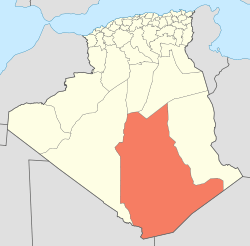 | |||||||
|---|---|---|---|---|---|---|---|---|
| In Salah District | ||||||||
| Tazrouk District | ||||||||
| Abalessa District | ||||||||
| In Ghar District | ||||||||
| Tin Zaouatine District | ||||||||
| In Guezzam District | ||||||||