Illizi
| Illizi ﻳﻠﻴﺰى | |
|---|---|
| city | |
|
Photo from Illizi. The text reads: "J'aime la nature, Je la protège", meaning "I love Nature, therefore I protect it". | |
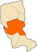 Location of Illizi Commune within Illizi Province | |
 Illizi Location of Illizi within Algeria | |
| Coordinates: 26°30′18″N 8°28′56″E / 26.50500°N 8.48222°ECoordinates: 26°30′18″N 8°28′56″E / 26.50500°N 8.48222°E | |
| Country |
|
| Province | Illizi |
| District | Illizi District |
| Government | |
| • PMA Seats | 11 |
| Area | |
| • Total | 75,945 km2 (29,323 sq mi) |
| Elevation | 567 m (1,860 ft) |
| Population (2008)[1] | |
| • Total | 17,252 |
| • Density | 0.23/km2 (0.59/sq mi) |
| Time zone | CET (UTC+01) |
| Postal code | 37000 |
| ONS code | 3301 |

Illizi (Arabic: إيليزي) is a town and commune, coextensive with Illizi District,[2] situated in the south-eastern part of Algeria, and capital of Illizi Province. According to the 2008 census it is the largest commune by population in the province, with a population of 17,252,[1] up from 10,163 in 1998,[3] and an annual population growth rate of 5.5%, the highest in the province.[1] It is one of the gates to the Tassili N'Ajjer National Park with caves situated under the sands containing prehistoric drawings dating from 6000 years BC. There is a hotel and two camping sites, as well as many local tourist agencies.
Climate
Illizi has a hot desert climate (Köppen climate classification BWh), with long, extremely hot summers and short, very warm winters. The town is virtually rainless throughout the year as the average annual rainfall is around 10 mm (0.39 in), and summers are especially dry. The sky is always clear over Illizi all year long and the relative humidity is very low.
| Climate data for Illizi | |||||||||||||
|---|---|---|---|---|---|---|---|---|---|---|---|---|---|
| Month | Jan | Feb | Mar | Apr | May | Jun | Jul | Aug | Sep | Oct | Nov | Dec | Year |
| Average high °C (°F) | 20.4 (68.7) |
25.8 (78.4) |
28.9 (84) |
33.3 (91.9) |
38.6 (101.5) |
41.8 (107.2) |
42.4 (108.3) |
42.0 (107.6) |
39.9 (103.8) |
35.3 (95.5) |
27.8 (82) |
21.8 (71.2) |
33.17 (91.68) |
| Daily mean °C (°F) | 12.7 (54.9) |
17.6 (63.7) |
21.3 (70.3) |
25.9 (78.6) |
30.4 (86.7) |
34.5 (94.1) |
34.9 (94.8) |
34.7 (94.5) |
32.9 (91.2) |
27.3 (81.1) |
21.3 (70.3) |
14.2 (57.6) |
25.64 (78.15) |
| Average low °C (°F) | 4.9 (40.8) |
9.5 (49.1) |
13.6 (56.5) |
18.4 (65.1) |
22.2 (72) |
27.2 (81) |
27.5 (81.5) |
27.4 (81.3) |
25.9 (78.6) |
18.9 (66) |
14.7 (58.5) |
6.6 (43.9) |
18.07 (64.52) |
| Average precipitation mm (inches) | 0.6 (0.024) |
0.9 (0.035) |
1.2 (0.047) |
1.1 (0.043) |
1.0 (0.039) |
0.1 (0.004) |
0.1 (0.004) |
0.1 (0.004) |
1.3 (0.051) |
1.8 (0.071) |
0.5 (0.02) |
1.5 (0.059) |
10.2 (0.401) |
| Average relative humidity (%) | 48 | 39 | 33 | 30 | 27 | 27 | 24 | 22 | 25 | 32 | 43 | 42 | 32.7 |
| Source: Weatherbase [4] | |||||||||||||
Transport
Illizi lies on the N3 national highway, which leads north to In Amenas and Touggourt and south to Djanet.
The town is served by Takhamalt Airport, with flights to Ghardaïa and Ouargla.[5]
Economy
The commune of Illizi includes five villages generating their own solar energy as part of a project to introduce solar energy to Algeria: Tihahiout, Ifni, Imehrou, Oued Semen, and Tamadjert.
Education
8.4% of the population has a tertiary education (the highest rate in the province), and another 15.7% has completed secondary education.[6] The overall literacy rate is 78.1%, and is 85.2% among males and 69.0% among females.[7]
Localities
The commune is composed of eight localities:[8]
See also
References
- 1 2 3 "Population: Illizi Wilaya" (PDF) (in French). Office National des Statistiques Algérie. Retrieved 16 May 2013.
- ↑ "Décret executif n° 91-306 du 24 août 1991 fixant la liste des communes animées par cheque chef de daïra. Wilaya d'Illizi" (PDF) (in French). Journal officiel de la République Algérienne,. 4 September 1991. p. 1293. Archived from the original (PDF) on 2 March 2013 or before. Retrieved 29 May 2013. Check date values in:
|archive-date=(help) - ↑ "Algeria Communes". Statoids. Retrieved 16 May 2013.
- ↑ "Illizi, Algeria Travel Weather Averages". Weatherbase. Retrieved 16 May 2013.
- ↑ "Routes to/from Illizi Takhamalt Airport". OurAirports. Retrieved 16 May 2013.
- ↑ "Structure relative de la population résidente des ménages ordinaires et collectifs âgée de 6 ans et plus selon le niveau d'instruction et la commune de résidence." (PDF) (in French). Office National des Statistiques Algérie. Retrieved 13 February 2013.
- ↑ "Taux d'analphabétisme et taux d'alphabétisation de la population âgée de 15 ans et plus, selon le sexe et la commune de résidence ." (PDF) (in French). Office National des Statistiques Algérie. Retrieved 13 February 2013.
- ↑ "Décret n° 84-365, fixant la composition, la consistance et les limites territoriale des communes. Wilaya d'El Oued" (PDF) (in French). Journal officiel de la République Algérienne,. 19 December 1984. p. 1551. Archived from the original (PDF) on 2 March 2013 or before. Retrieved 2 March 2013. Check date values in:
|archive-date=(help)
External links
 |
Ouargla Bordj Omar Driss |
Debdeb Ohanet |
In Amenas | |
| In Salah (Tamanrasset) Adrar |
|
Ubari (Libya) | ||
| ||||
| | ||||
| Ifni Idlès (Tamanrasset) Tamanrasset |
Imehrou Bordj El Houasse |
Tarat Djanet |
