Sting jet
A sting jet is a meteorological phenomenon which has been postulated to cause some of the most damaging winds in extratropical cyclones, developing according to the Shapiro-Keyser model of oceanic cyclones.
Concept

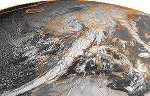
Following reanalysis of the Great Storm of 1987, led by Professor Keith Browning at the University of Reading, researchers identified a mesoscale flow where the most damaging winds were shown to be emanating from the evaporating tip of the hooked cloud head on the southern flank of the cyclone. This cloud, hooked like a scorpion's tail, gives the wind region its name the "sting jet".[2]
It is thought that a zone of strong winds, originating from within the mid-tropospheric cloud head of an explosively deepening depression, are enhanced further as the "jet" descends, drying out and evaporating a clear path through snow and ice particles. The evaporative cooling leading to the air within the jet becoming denser, leading to an acceleration of the downward flow towards the tip of the cloud head when it begins to hook around the cyclone centre. Windspeeds in excess of 80 kn (150 km/h) can be associated with the sting jet.[3]
It has since been reproduced in high-resolution runs with the mesoscale version of the Unified Model. The sting jet is distinct from the usual strong-wind region associated with the warm conveyor belt and main cold front. There are indications that conditional symmetric instability also plays a role in its formation but the importance of these processes remains to be quantified.[4][5]
One North Atlantic storm, Cyclone Tilo (November 6–11, 2007) has also been analysed and found not to display a sting jet, despite displaying strong surface winds and a fractured cold front.[5]
Globally
The sting jet mechanism has been considered less significant in Pacific Northwest windstorms which occur over the Pacific Ocean (which impact the Northwestern United States and British Columbia).[6] Evidence of mesoscale high wind areas has not been noted in most large windstorms occurring there, along with cloud geometry associated with the phenomena being absent in satellite imagery of major Pacific Northwest storms.[6] Although a case study of a sting jet in the region has been produced.[7] High resolution computer models of the phenomena have also shown realistically strong winds without the need for sting jet dynamics.[6]
List of sting jet cyclones
| Cyclone | Type | Date | Reference | Location |
|---|---|---|---|---|
| Great Storm of 1987 | European windstorm | October 15-17, 1987 | [8][9][10] | Southern England |
| Oratia | European windstorm | October 30, 2000 | [10][11] | North Sea (Lincolnshire to Norway) |
| Anna | European windstorm | February 26, 2002 | [12] | Central Pennines, England |
| Jeanette | European windstorm | October 27, 2002 | [13][14] | Wales and the English Midlands |
| Erwin | European windstorm | January 2005 | [14][15][16][17] | Northern England |
| Friedhelm | European windstorm | December 8, 2011 | [18][19][20] | Central Belt Scotland |
| Ulli | European windstorm | January 3–4, 2012 | [21][22][23][24][25][26] | Central Belt Scotland |
List of proposed sting jets
| Cyclone | Type | Date | Reference | Location |
|---|---|---|---|---|
| New Year's Day Storm | European Windstorm | January 1, 1992 | [27][28] | Norway |
| Renate | European windstorm | October 3, 2006 | [28] | Bay of Biscay and Aquitaine, France |
| "Oeste storm" | European windstorm | December 23, 2009 | [29] | Portugal |
| October 2010 North American storm complex | Great Lakes cyclone | October 26–27, 2010 | [21] | Midwest USA |
| 2011 Halloween nor'easter | Nor'easter | October 30–31, 2011 | [21][30] | Northeastern USA |
| Unnamed | Extratropical cyclone | March 12, 2012 | [31] | Upper Midwest USA |
| Gong | European windstorm | January 19, 2013 | [29] | Portugal |
| St Jude storm (Christian) | European windstorm | October 28, 2013 | [32][33] | Possibly developing over East Anglia then over the North Sea, skirting the Netherlands coast to Germany/Denmark. |
| Cyclone Tini/storm Darwin | European windstorm | February 12, 2014 | [34] | Southern Ireland, Irish Sea, Wales. |
| Arthur | Extratropical cyclone ex–Hurricane | July 5, 2014 | [35][36] | Canadian Maritimes |
| Elon (Nathan) | European windstorm | January 9, 2015 | [37][38][39] | Scotland |
External links
- The Sting Jet: Forecasting the damaging winds in European Cyclones, UK Met Office
- The 1987 Great Storm - What is a Sting Jet?, UK Met Office
- EUMeTrain webcast, "Sting Jets" Prof. Geraint Vaughan, School of Earth, Atmospheric and Environmental Sciences, The University of Manchester
Further reading
- Quarterly Journal of the Royal Meteorological Society 140: 96 – 110, January 2014 Idealised simulations of sting-jet cyclones
- Do North Pacific sting jet cyclones exist?
- NOAA Conditional Symmetric Iinstability (CSI) homepage
References
- ↑ Hewson, Tim D.; Neu, URS (2015-01-01). "Cyclones, windstorms and the IMILAST project". Tellus A. 67. doi:10.3402/tellusa.v67.27128.
- ↑ Browning, Keith; Peter Clark; Tim Hewson; Robert Muir-Wood (2003). "Damaging winds from European cyclones". The Royal Society. Retrieved 27 March 2013.
- ↑ Meteorological glossary Booty.org, retrieved 2007-17-10
- ↑ Cyclonic storms UWERN newsletter, retrieved 2007-17-10
- 1 2 Gray, S. L.; Martínez-Alvarado, O.; Baker, L. H.; Clark, P. A. (2011). "Conditional symmetric instability in sting-jet storms". Quarterly Journal of the Royal Meteorological Society. 137 (659): 1482–1500. Bibcode:2011QJRMS.137.1482G. doi:10.1002/qj.859.
- 1 2 3 Mass, Clifford; Dotson, Brigid (2010). "Major Extratropical Cyclones of the Northwest United States: Historical Review, Climatology, and Synoptic Environment". Monthly Weather Review. 138 (7): 2499–2527. Bibcode:2010MWRv..138.2499M. doi:10.1175/2010MWR3213.1. Retrieved 15 November 2013.
- ↑ Doyle, Chris; Ruping, Mo (16 December 2015). "A Rather Rare West-Coast Sting-Jet Event during December 12-13th, 2015" (PDF). National Laboratory for Coastal and Mountain Meteorology, Environment and Climate Change Canada, Technical Report 2015-001 National Laboratory for Coastal and Mountain Meteorology. Retrieved 14 April 2016.
- ↑ Browning, K. A. (2004). "The sting at the end of the tail: Damaging winds associated with extratropical cyclones". Quarterly Journal of the Royal Meteorological Society. 130 (597): 375–399. Bibcode:2004QJRMS.130..375B. doi:10.1256/qj.02.143.
- ↑ Clark, P. A.; Browning, K. A.; Wang, C. (2005). "The sting at the end of the tail: Model diagnostics of fine-scale three-dimensional structure of the cloud head". Quarterly Journal of the Royal Meteorological Society. 131 (610): 2263–2292. Bibcode:2005QJRMS.131.2263C. doi:10.1256/qj.04.36.
- 1 2 "A sting in the tale of the Great Storm". Daily Telegraph. Retrieved 4 February 2012.
- ↑ . doi:10.1002/j.1477-8696.2001.tb06547 (inactive 2015-11-13). Missing or empty
|title=(help) - ↑ Martínez-Alvarado, Oscar; Florian Weidle; Suzanne L. Gray (2010). "Sting Jets in Simulations of a Real Cyclone by Two Mesoscale Models". Monthly Weather Review. 138 (11): 4054–4075. Bibcode:2010MWRv..138.4054M. doi:10.1175/2010MWR3290.1.
- ↑ Parton, G. A.; Vaughan, G.; Norton, E. G.; Browning, K. A.; Clark, P. A. (2009). "Wind profiler observations of a sting jet". Quarterly Journal of the Royal Meteorological Society. 135 (640): 663–680. doi:10.1002/qj.398.
- 1 2 Baker, Laura (2009). "Sting jets in severe northern European wind storms". Weather. 64 (6): 143–148. Bibcode:2009Wthr...64..143B. doi:10.1002/wea.397.
- ↑ Knox; et al. (2011). "Non-Convective High Winds Associated with Extratropical Cyclones" (pdf). Geography Compass 5/2. Retrieved 4 February 2012.
- ↑ "stingjets" (PDF). Geographical Association. Retrieved 5 February 2012.
- ↑ "Case analysis of Gudrun". Department of Meteorology, University of Reading. Retrieved 17 April 2012.
- ↑ "Weather: A storm called Friedhelm". Meteogroup. Retrieved 4 February 2012.
- ↑ "Northern UK, Scotland Battered by Windstorm Friedhelm: AIR Analysis". AIR worldwide. Retrieved 4 February 2012.
- ↑ "Cyclone Friedhelm: a potential sting jet case". NCAS blog, Leeds University. Retrieved 29 February 2012.
- 1 2 3 "Non-Convective High Wind Events: Investigating the Influence of Stratospheric Intrusions on Non-Convective High Wind Events Using RGB Air Mass Product" (PDF) (Technical Report). Saint Louis University Center for Environmental Sciences. Retrieved 18 October 2012.
- ↑ "Winter storm blasts the UK" (flash). BBC. Retrieved 4 February 2012.
- ↑ ""Sting Jet" signature associated with a high wind event in Scotland". Space Science and Engineering Center CIMSS Satellite Blog. Retrieved 5 February 2012.
- ↑ Grumm, Richard H. "Scottish Windstorm 3 January 2012" (PDF). National Weather Service-Pennsylvania State University Weather Events. National Weather Service-Pennsylvania State University. Retrieved 5 February 2012.
- ↑ "Sting jet signature associated with a high wind event in Scotland (storm Ulli, 3 January 2012)". Eumetsat. Retrieved 18 March 2012.
- ↑ Smart, D. J.; Browning, K. A. (January 2014). "Attribution of strong winds to a cold conveyor belt and sting jet". Quarterly Journal of the Royal Meteorological Society. 140 (679): 595–610. Bibcode:2014QJRMS.140..595S. doi:10.1002/qj.2162. Retrieved 4 October 2015.
- ↑ GRONAS, SIGBJORN (September 1995). "The seclusion intensification of the New Year's day storm 1992". Tellus A. 47 (5): 733–746. Bibcode:1995TellA..47..733G. doi:10.1034/j.1600-0870.1995.00116.x.
- 1 2 Hewson, Tim D.; Neu, URS (31 August 2015). "Cyclones, windstorms and the IMILAST project". Tellus A. 67. doi:10.3402/tellusa.v67.27128. Retrieved 21 October 2015.
- 1 2 Miranda, Pedro (2014). "Dynamics of the Gong windstorm (Jan 2013) in the context of a 20-year high-resolution simulation of Iberian climate" (PDF). EGU General Assembly Conference Abstracts. Retrieved 7 September 2014.
- ↑ "NASA DEVELOP Summer 2012 Project Summary". Saint Louis University Center for Environmental Sciences. Retrieved 18 October 2012.
- ↑ "Possible Sting Jet in Upper Midwest". Space Science and Engineering Centre CIMSS Satellite Blog. Retrieved 17 October 2012.
- ↑ "Orkan Christian". Retrieved 28 October 2013.
- ↑ Hammond, John (30 October 2013). "How 'Sting Jets' influence our weather". BBC Weather. Retrieved 15 November 2013.
- ↑ Volonte, Ambrogio; Clark, Peter A.; Grey, Suzanne L. (2015). "Sting Jet analyses in extratropical cyclones" (PDF). Swiss Climate Summer School 2015: Extreme Events and Climate. Retrieved 5 October 2015.
- ↑ "Tropical Cyclone Information Statement for Post-Tropical Cyclone Arthur". Canadian Hurricane Centre. Environment Canada. 6 June 2014. Retrieved 8 August 2014.
- ↑ "Hurricane Arthur transitions to an extratropical cyclone". University of Wisconsin-Madison/ Space Science and Engineering Center CIMSS Satellite Blog. 6 July 2014. Retrieved 8 August 2014.
- ↑ "Metcheck Facebook page". Retrieved 9 January 2015.
- ↑ "Storm Forecast". European Storm Forecast Experiment. Retrieved 9 January 2015.
- ↑ "Thema Des tages 16 Jan 2015: Wenn der Skorpion zusticht". DWD. 16 January 2015. Retrieved 14 October 2015.