Spreenhagen
| Spreenhagen | |
|---|---|
 Spreenhagen | |
Location of Spreenhagen within Oder-Spree district  | |
| Coordinates: 52°20′37″N 13°52′28″E / 52.34361°N 13.87444°ECoordinates: 52°20′37″N 13°52′28″E / 52.34361°N 13.87444°E | |
| Country | Germany |
| State | Brandenburg |
| District | Oder-Spree |
| Municipal assoc. | Spreenhagen |
| Government | |
| • Mayor | Dr. Ralf-Eckhard Paesch (GfB) |
| Area | |
| • Total | 136.00 km2 (52.51 sq mi) |
| Population (2015-12-31)[1] | |
| • Total | 3,229 |
| • Density | 24/km2 (61/sq mi) |
| Time zone | CET/CEST (UTC+1/+2) |
| Postal codes | 15528 |
| Dialling codes | 033633 |
| Vehicle registration | LOS |
| Website | www.amt-spreenhagen.de |
Spreenhagen (Lower Sorbian: Sprjewiny Ług) is a municipality in the Oder-Spree district, in Brandenburg, Germany.
Demography
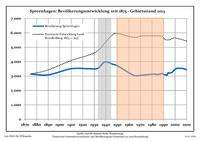
Development of population since 1875 within the current boundaries (Blue line: Population; Dotted line: Comparison to population development of Brandenburg state; Grey background: Time of Nazi rule; Red background: Time of communist rule)
|
|
|
|
Local council
The local council of Spreenhagen has 16 members. Elections were held on May 25, 2014 with the following results:
- SPD = 35.8% (6 seats)
- GfB (Free Citizens) = 28.9% (5 seats)
- DCM (Club Markgrafpieske)= 13.0% (2 seats)
- LINKE = 9.2% (1 seat)
- CDU = 7.5% (1 seat)
- NPD = 5.6% (1 seat)
Notable Residents
- Marienetta Jirkowsky (1962–1980), one of at least 138 victims at the Berlin Wall; also one of only eight female victims, and the youngest of those eight female victims..[3]
References
- ↑ "Bevölkerung im Land Brandenburg nach amtsfreien Gemeinden, Ämtern und Gemeinden 31. Dezember 2015 (Fortgeschriebene amtliche Einwohnerzahlen auf Grundlage des Zensus 2011)". Amt für Statistik Berlin-Brandenburg (in German). 2016.
- ↑ Detailed data sources are to be found in the Wikimedia Commons.Population Projection Brandenburg at Wikimedia Commons
- ↑ Portrait of Marienetta Jirkowsky at chronik-der-mauer.de
This article is issued from Wikipedia - version of the 11/13/2016. The text is available under the Creative Commons Attribution/Share Alike but additional terms may apply for the media files.