Gosen-Neu Zittau
Gosen-Neu Zittau is a municipality in the Oder-Spree district, in Brandenburg, Germany. Neu Zittau is situated in the Spree valley, near the Oder-Spree-Canal.
Geography
Neighbouring places
Division of the town
- Gosen
- Neu Zittau
- Burig
- Steinfurt
Demography
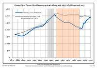
Development of population since 1875 within the current boundaries (Blue line: Population; Dotted line: Comparison to population development of Brandenburg state; Grey background: Time of Nazi rule; Red background: Time of communist rule)
Gosen-Neu Zittau:
Population development within the current boundaries[2]
| Year |
Population |
|
|
|---|
| 1875 | 1 672 |
| 1890 | 1 573 |
| 1910 | 2 109 |
| 1925 | 2 279 |
| 1933 | 2 667 |
| 1939 | 2 851 |
| 1946 | 3 074 |
| 1950 | 2 873 |
| 1964 | 2 522 |
| 1971 | 2 536 |
|
|
| Year |
Population |
|
|
|---|
| 1981 | 2 311 |
| 1985 | 2 203 |
| 1989 | 2 192 |
| 1990 | 2 123 |
| 1991 | 2 100 |
| 1992 | 2 133 |
| 1993 | 2 093 |
| 1994 | 2 095 |
| 1995 | 2 106 |
| 1996 | 2 217 |
|
|
| Year |
Population |
|
|
|---|
| 1997 | 2 366 |
| 1998 | 2 480 |
| 1999 | 2 502 |
| 2000 | 2 455 |
| 2001 | 2 543 |
| 2002 | 2 634 |
| 2003 | 2 688 |
| 2004 | 2 726 |
| 2005 | 2 731 |
| 2006 | 2 764 |
|
|
| Year |
Population |
|
|
|---|
| 2007 | 2 797 |
| 2008 | 2 880 |
| 2009 | 2 888 |
| 2010 | 2 900 |
| 2011 | 3 020 |
| 2012 | 2 991 |
| 2013 | 3 002 |
|
|
References

