Mixdorf
Mixdorf is a municipality in the Oder-Spree district, in Brandenburg, Germany.
Demography
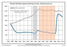
Development of Population since 1875 within the Current Boundaries (Blue Line: Population; Dotted Line: Comparison to Population Development of Brandenburg state; Grey Background: Time of Nazi rule; Red Background: Time of Communist rule)
Mixdorf:
Population development within the current boundaries[2]
| Year |
Population |
|
|
|---|
| 1875 | 670 |
| 1890 | 317 |
| 1910 | 312 |
| 1925 | 307 |
| 1933 | 288 |
| 1939 | 268 |
| 1946 | 388 |
| 1950 | 360 |
| 1964 | 316 |
| 1971 | 313 |
|
|
| Year |
Population |
|
|
|---|
| 1981 | 263 |
| 1985 | 279 |
| 1989 | 265 |
| 1990 | 262 |
| 1991 | 259 |
| 1992 | 277 |
| 1993 | 389 |
| 1994 | 634 |
| 1995 | 838 |
| 1996 | 958 |
|
|
| Year |
Population |
|
|
|---|
| 1997 | 1 032 |
| 1998 | 1 063 |
| 1999 | 1 074 |
| 2000 | 1 060 |
| 2001 | 1 055 |
| 2002 | 1 051 |
| 2003 | 1 043 |
| 2004 | 1 037 |
| 2005 | 1 020 |
| 2006 | 1 009 |
|
|
| Year |
Population |
|
|
|---|
| 2007 | 993 |
| 2008 | 972 |
| 2009 | 958 |
| 2010 | 955 |
| 2011 | 940 |
| 2012 | 927 |
| 2013 | 914 |
|
|
References


