South Hampton, New Hampshire
| South Hampton, New Hampshire | |
|---|---|
| Town | |
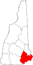
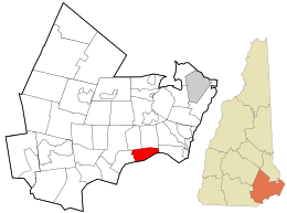 Location in Rockingham County and the state of New Hampshire. | |
| Coordinates: 42°52′51″N 70°57′45″W / 42.88083°N 70.96250°WCoordinates: 42°52′51″N 70°57′45″W / 42.88083°N 70.96250°W | |
| Country | United States |
| State | New Hampshire |
| County | Rockingham |
| Incorporated | 1742 |
| Government | |
| • Board of Selectmen |
Ronald Preston John A. Gamble James van Bokkelen |
| Area | |
| • Total | 8.0 sq mi (20.7 km2) |
| • Land | 7.9 sq mi (20.4 km2) |
| • Water | 0.1 sq mi (0.3 km2) 1.62% |
| Elevation | 200 ft (61 m) |
| Population (2010) | |
| • Total | 814 |
| • Density | 100/sq mi (39/km2) |
| Time zone | Eastern (UTC-5) |
| • Summer (DST) | Eastern (UTC-4) |
| ZIP code | 03827 |
| Area code(s) | 603 |
| FIPS code | 33-71140 |
| GNIS feature ID | 0873722 |
| Website |
www |
South Hampton is a town in Rockingham County, New Hampshire, United States. The population was 814 at the 2010 census.[1] South Hampton is home to Cowden State Forest and Powwow River State Forest.
History

South Hampton was one of the first towns granted by Colonial Governor Benning Wentworth after the separation of the governorships of New Hampshire and Massachusetts in 1741. The border between the two colonies was fixed, and consequently South Hampton would be chartered in 1742 from former parts of Amesbury and Salisbury, Massachusetts. Over the years, the town lost territory to Hampton Falls, Seabrook and Newton, but gained territory from East Kingston in 1824.
The town's Justices of the Peace in 1831 were Parker Merrill, George W. Pillsbury, Benning Leavitt, John Palmer and A. Brown.[2]
At one time, the town was home to over 12 different religious sects. One of South Hampton's only members of the New Hampshire State Senate was Benjamin Barnard, who served from 1806-1808.
There is only one school in South Hampton. Called Barnard School, it was originally just a small room, but then a school was built across the street. It is home to K-8 students, and once they become high schoolers, they move on to Amesbury High School in Massachusetts.
Geography
According to the United States Census Bureau, the town has a total area of 8.0 square miles (21 km2), of which 7.9 sq mi (20 km2) is land and 0.1 sq mi (0.26 km2) is water, comprising 1.62% of the town. South Hampton is drained by the Powwow River, part of the Merrimack River watershed. The highest point in town is the summit of Chair Hill, at 330 feet (100 m) above sea level, near the eastern end of town.
Attractions in South Hampton include Heron Pond Farm and Jewell Towne Vineyards.
Demographics
| Historical population | |||
|---|---|---|---|
| Census | Pop. | %± | |
| 1790 | 448 | — | |
| 1800 | 387 | −13.6% | |
| 1810 | 427 | 10.3% | |
| 1820 | 416 | −2.6% | |
| 1830 | 487 | 17.1% | |
| 1840 | 462 | −5.1% | |
| 1850 | 472 | 2.2% | |
| 1860 | 549 | 16.3% | |
| 1870 | 448 | −18.4% | |
| 1880 | 383 | −14.5% | |
| 1890 | 370 | −3.4% | |
| 1900 | 297 | −19.7% | |
| 1910 | 279 | −6.1% | |
| 1920 | 230 | −17.6% | |
| 1930 | 261 | 13.5% | |
| 1940 | 294 | 12.6% | |
| 1950 | 314 | 6.8% | |
| 1960 | 443 | 41.1% | |
| 1970 | 558 | 26.0% | |
| 1980 | 660 | 18.3% | |
| 1990 | 740 | 12.1% | |
| 2000 | 844 | 14.1% | |
| 2010 | 814 | −3.6% | |
| Est. 2015 | 809 | [3] | −0.6% |
As of the census[5] of 2000, there were 844 people, 301 households, and 244 families residing in the town. The population density was 107.2 people per square mile (41.4/km²). There were 308 housing units at an average density of 39.1 per square mile (15.1/km²). The racial makeup of the town was 97.99% White, 0.59% African American, 0.12% Asian, 0.47% Pacific Islander, and 0.83% from two or more races. Hispanic or Latino of any race were 0.36% of the population.
There were 301 households out of which 34.9% had children under the age of 18 living with them, 69.1% were married couples living together, 7.6% had a female householder with no husband present, and 18.9% were non-families. 13.0% of all households were made up of individuals and 6.3% had someone living alone who was 65 years of age or older. The average household size was 2.80 and the average family size was 3.07.
In the town the population was spread out with 24.9% under the age of 18, 4.3% from 18 to 24, 28.7% from 25 to 44, 28.7% from 45 to 64, and 13.5% who were 65 years of age or older. The median age was 40 years. For every 100 females there were 88.8 males. For every 100 females age 18 and over, there were 89.3 males.
The median income for a household in the town was $63,750, and the median income for a family was $75,778. Males had a median income of $45,156 versus $30,625 for females. The per capita income for the town was $28,287. About 0.8% of families and 2.7% of the population were below the poverty line, including 3.4% of those under age 18 and none of those age 65 or over.
References
- ↑ United States Census Bureau, American FactFinder, 2010 Census figures. Retrieved March 23, 2011.
- ↑ The New-Hampshire Annual Register, and United States Calendar, John Farmer, Hoag and Atwood, Concord, N.H., 1832
- ↑ "Annual Estimates of the Resident Population for Incorporated Places: April 1, 2010 to July 1, 2015". Retrieved July 2, 2016.
- ↑ "Census of Population and Housing". Census.gov. Retrieved June 4, 2016.
- ↑ "American FactFinder". United States Census Bureau. Retrieved 2008-01-31.
External links
- Town of South Hampton official website
- South Hampton Police Department
- New Hampshire Economic and Labor Market Information Bureau Profile