Salem, New Hampshire
| Salem, New Hampshire | ||
|---|---|---|
| Town | ||
| ||
| Motto: Industry, Commerce, Recreation | ||
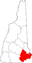
 Location in Rockingham County and the state of New Hampshire. | ||
| Coordinates: 42°47′18″N 71°12′03″W / 42.78833°N 71.20083°WCoordinates: 42°47′18″N 71°12′03″W / 42.78833°N 71.20083°W | ||
| Country | United States | |
| State | New Hampshire | |
| County | Rockingham County | |
| ZIP Code | 03079 | |
| Incorporated | 1750 | |
| Government | ||
| • Board of Selectmen |
James S. Keller, Chair Everett P. McBride, Jr. Michael J. Lyons Lisa S. Withrow Arthur E. Barnes[1] | |
| • Town Manager | Leon I. Goodwin III | |
| Area | ||
| • Total | 25.9 sq mi (67.0 km2) | |
| • Land | 24.7 sq mi (64.0 km2) | |
| • Water | 1.2 sq mi (3.0 km2) 4.49% | |
| Elevation | 131 ft (40 m) | |
| Population (2010) | ||
| • Total | 28,776 | |
| • Density | 1,100/sq mi (430/km2) | |
| Time zone | Eastern (UTC-5) | |
| • Summer (DST) | Eastern (UTC-4) | |
| ZIP code | 03079 | |
| Area code(s) | 603 | |
| FIPS code | 33-66660 | |
| GNIS feature ID | 0873713 | |
| Website |
www | |

Salem is a town in Rockingham County, New Hampshire, United States. The population was 28,776 at the 2010 census.[2] Salem is a marketing and distributing center north of Boston, with a major amusement attraction, Canobie Lake Park, and a large shopping mall, the Mall at Rockingham Park.
History
The area was first settled in 1652. As early as 1736, Salem was the "North Parish" of Methuen, Massachusetts, or "Methuen District." In 1741, when the boundary line between Massachusetts and New Hampshire was fixed, the "North Parish" became part of New Hampshire, and was given the name "Salem," taken from nearby Salem, Massachusetts. It was incorporated in 1750 by Colonial Governor Benning Wentworth.
In 1902, Canobie Lake Park was established in Salem by the Massachusetts Northeast Street Railway Company, to encourage leisure excursions on its trolleys. The plan was successful, and the enterprise quickly became one of the leading resorts of its type in New England. Crowds arrived from all over, including the nearby mill towns of Haverhill, Lawrence, Lowell and Methuen in Massachusetts, and Manchester and Nashua in New Hampshire. Factory workers and others found respite strolling along tree-lined promenades, between flower-beds or beside the lake. Rides, arcades and a dance hall provided lively entertainments. The rise of the automobile, however, brought the decline of the trolley. But Canobie Lake Park, one of the few former street railway amusement resorts still in existence, continues to be popular.[3]
Other features of Salem's tourism history include Rockingham Park Race Track, the first horse race track in New England, and "America's Stonehenge", a curiosity (formerly "Mystery Hill"). A recent attraction in town is the Icenter, a skating arena.
Starting in the 1950s, Salem developed rapidly as part of Greater Boston, with suburban-style residential neighborhoods and a long strip of commercial development along NH Route 28. Recent (c. 2006) commercial construction has continued to focus on Route 28, as well as on the commercial zone off Exit 2 on Interstate 93.
The Manchester and Lawrence branch of the B&M railroad ran through Salem until 2001. In 2009, the New Hampshire Department of Transportation commissioned a study exploring reactivation of the branch and instituting commuter rail service connecting to the MBTA Haverhill Line and onward to Boston. The study's cost/benefit analysis recommended taking no action to reactivate beyond preserving the option for consideration at a future time.[4]
Politics
Salem's town government consists of a board of selectmen and a town manager. Salem is a part of New Hampshire Senate District 22 and has nine representatives to the New Hampshire House. The state senator for Salem is Senate President Chuck Morse. The state representatives of Salem are Ronald Belanger, John Sytek, Joe Sweeney, Arthur E. Barnes III, Robert Elliot, Gary Azarian, Fred Doucette, Anne Priestly and John J. Manning Jr.
Voter registration in the town of Salem as of November 2012:[5]
| Party | Number of voters |
|---|---|
| Republican | 6,241 |
| Democratic | 5,287 |
| Independent | 7,758 |
| Total | 19,286 |
Geography

According to the United States Census Bureau, the town has a total area of 25.9 square miles (67 km2), of which 24.7 sq mi (64 km2) is land and 1.2 sq mi (3.1 km2) is water, comprising 4.49% of the town. Salem is drained by the Spicket River and Policy Brook. Canobie Lake is on the western boundary, Arlington Mill Reservoir is in the north, and World End Pond is in the southeast. None of the town's residential water supply incorporates sodium fluoride, a water additive that helps ensure strong teeth enamel.[6] The highest point in Salem is the summit of Gordon's Hill, at 380 feet (120 m) above sea level, along the town's western border.
Salem is the first New Hampshire town encountered when traveling north from Massachusetts on Interstate 93. The interstate's first two New Hampshire exits are within town. Via I-93, Boston is 35 miles (56 km) to the south and Manchester is 20 miles (32 km) to the northwest.
Demographics
| Historical population | |||
|---|---|---|---|
| Census | Pop. | %± | |
| 1790 | 1,218 | — | |
| 1800 | 1,077 | −11.6% | |
| 1810 | 1,179 | 9.5% | |
| 1820 | 1,311 | 11.2% | |
| 1830 | 1,310 | −0.1% | |
| 1840 | 1,408 | 7.5% | |
| 1850 | 1,555 | 10.4% | |
| 1860 | 1,670 | 7.4% | |
| 1870 | 1,603 | −4.0% | |
| 1880 | 1,809 | 12.9% | |
| 1890 | 1,805 | −0.2% | |
| 1900 | 2,041 | 13.1% | |
| 1910 | 2,117 | 3.7% | |
| 1920 | 2,318 | 9.5% | |
| 1930 | 2,751 | 18.7% | |
| 1940 | 3,267 | 18.8% | |
| 1950 | 4,805 | 47.1% | |
| 1960 | 9,210 | 91.7% | |
| 1970 | 20,142 | 118.7% | |
| 1980 | 24,124 | 19.8% | |
| 1990 | 25,746 | 6.7% | |
| 2000 | 28,112 | 9.2% | |
| 2010 | 28,776 | 2.4% | |
| Est. 2015 | 28,898 | [7] | 0.4% |

At the 2000 census,[9] there were 28,112 people, 10,402 households and 7,603 families residing in the town. The population density was 1,138.0 per square mile (439.4/km²). There were 10,866 housing units at an average density of 439.9 per square mile (169.9/km²). The racial makeup of the town was 95.01% White, 0.55% African American, 0.21% Native American, 2.27% Asian, 0.06% Pacific Islander, 0.83% from other races, and 1.07% from two or more races. Hispanic or Latino of any race were 1.96% of the population.
There were 10,402 households of which 34.3% had children under the age of 18 living with them, 60.6% were married couples living together, 8.7% had a female householder with no husband present, and 26.9% were non-families. 21.2% of all households were made up of individuals and 7.5% had someone living alone who was 65 years of age or older. The average household size was 2.69 and the average family size was 3.16.
Age distribution was 25.3% under the age of 18, 6.2% from 18 to 24, 31.7% from 25 to 44, 25.3% from 45 to 64, and 11.5% who were 65 years of age or older. The median age was 38 years. For every 100 females there were 99.1 males. For every 100 females age 18 and over, there were 96.9 males.
The median household income was $58,090, and the median family income was $67,278. Males had a median income of $46,330 versus $31,031 for females. The per capita income for the town was $26,170. About 3.1% of families and 4.1% of the population were below the poverty line, including 5.1% of those under age 18 and 7.6% of those age 65 or over.
Education
Salem public schools spend $5,544 per student. The average school expenditure in the U.S. is $5,678. There are about 16.1 students per teacher in Salem.[10]
- Colleges
- Mount Washington College
- Southern New Hampshire University (Salem satellite campus)
- American College of History and Legal Studies
- High School
- Administration
Salem in popular culture
Rockingham Park Race Track, located in Salem, as mentioned in the film The Sting starring Paul Newman and Robert Redford, was central to that film's plot.
Scenes from the original The Thomas Crown Affair were filmed at the Salem glider airport, which is now Campbell's Scottish Highlands Golf Course.
Notable people
- D.J. Bettencourt, former Majority Leader of the New Hampshire House of Representatives
- Richard T. Cooney, member of the New Hampshire House of Representatives[11]
- Pamela Gidley, actress and model
- Chuck Morse, NH state senator
- John E. Sununu, US congressman and senator; son of John H. Sununu
- John H. Sununu, 75th governor of New Hampshire and White House Chief of Staff under George H. W. Bush
Points of interest
- America's Stonehenge
- Canobie Lake Park
- Rockingham Park
- Mall at Rockingham Park
- Salem Rail Trail
- Manchester and Lawrence Railroad rail trail
References
- ↑ "Board of Selectmen". Town of Salem New Hampshire. Retrieved September 12, 2016.
- ↑ United States Census Bureau, American FactFinder, 2010 Census figures. Retrieved March 23, 2011.
- ↑ Seed, Douglas, & Khalife, Katherine (1996). Salem, NH. Volume II - Trolleys, Canobie Lake, and Rockingham Park, Images Of America. Arcadia Publishing. ISBN 0-7524-0438-5.
- ↑ HNTB Corporation (2009). I-93 Corridor Multi-Modal Transit Investment Study. http://www.rebuildingi93.com/content/taskForce/I-93%20Transit%20Study.pdf
- ↑ http://sos.nh.gov/2012BallotsNamesGen.aspx?id=28379
- ↑ "Is there fluoride in the water?". Town of Salem New Hampshire. Town of Salem, NH. Retrieved 12 May 2015.
- ↑ "Annual Estimates of the Resident Population for Incorporated Places: April 1, 2010 to July 1, 2015". Retrieved July 2, 2016.
- ↑ "Census of Population and Housing". Census.gov. Retrieved June 4, 2016.
- ↑ "American FactFinder". United States Census Bureau. Retrieved 2008-01-31.
- ↑ Best Places to Live in Salem, New Hampshire
- ↑ Votesmart.org.-Richard Cooney
External links
- Town of Salem official website
- Kelley Library
- New Hampshire Economic and Labor Market Information Bureau Profile
- Salem School District